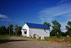
Homestown, Missouri

Last updated
Homestown, Missouri
Homestown-Wardell-Lodge-mo.jpg
Wardell Lodge #157 in Homestown
Pemiscot County Missouri Incorporated and Unincorporated areas Homestown Highlighted.svg
Location of Homestown, Missouri
Coordinates: 36°19′55″N89°49′27″W / 36.33194°N 89.82417°W / 36.33194; -89.82417 Coordinates: 36°19′55″N89°49′27″W / 36.33194°N 89.82417°W / 36.33194; -89.82417
Country United States
State Missouri
County Pemiscot
Area
[1]
  Total0.12 sq mi (0.32 km2)
  Land0.12 sq mi (0.32 km2)
  Water0.00 sq mi (0.00 km2)
Elevation
[2]
269 ft (82 m)
Population
 (2020)
  Total73
  Density593.50/sq mi (228.31/km2)
Time zone UTC-6 (Central (CST))
  Summer (DST) UTC-5 (CDT)
ZIP code
63879
Area code 573
FIPS code 29-32824 [3]
GNIS feature ID2394412 [2]

Homestown is a city in Pemiscot County, Missouri, United States. The population was 73 at the 2020 census. [4]

Contents

History

Homestown, originally known as South Wardell, was one of ten communities constructed by the Farm Security Administration for displaced sharecroppers and tenant farmers following the January 1939 roadside sharecropper demonstration in Southeast Missouri. It was the largest of the communities and was designated for use by African-Americans. [5] :11

The Delmo Community Center was listed on the National Register of Historic Places in 2009. [6]

Geography

According to the United States Census Bureau, the city has a total area of 0.12 square miles (0.31 km2), all land. [7]

Demographics

Miracle Temple Church of God in Christ in Homestown Homestown-Miracle-Temple-mo.jpg
Miracle Temple Church of God in Christ in Homestown
Historical population
CensusPop.Note
1960 274
1970 273−0.4%
1980 30612.1%
1990 230−24.8%
2000 181−21.3%
2010 151−16.6%
2020 73−51.7%
U.S. Decennial Census [8]

2010 census

As of the census [9] of 2010, there were 151 people, 53 households, and 38 families living in the city. The population density was 1,258.3 inhabitants per square mile (485.8/km2). There were 66 housing units at an average density of 550.0 per square mile (212.4/km2). The racial makeup of the city was 2.65% White, 95.36% Black or African American, 0.66% Native American, and 1.32% from two or more races.

There were 53 households, of which 32.1% had children under the age of 18 living with them, 28.3% were married couples living together, 28.3% had a female householder with no husband present, 15.1% had a male householder with no wife present, and 28.3% were non-families. 22.6% of all households were made up of individuals, and 7.5% had someone living alone who was 65 years of age or older. The average household size was 2.85 and the average family size was 3.32.

The median age in the city was 32.6 years. 29.8% of residents were under the age of 18; 10.6% were between the ages of 18 and 24; 24.5% were from 25 to 44; 27.1% were from 45 to 64; and 7.9% were 65 years of age or older. The gender makeup of the city was 53.0% male and 47.0% female.

2000 census

As of the census [3] of 2000, there were 181 people, 61 households, and 48 families living in the city. The population density was 1,452.6 inhabitants per square mile (560.9/km2). There were 77 housing units at an average density of 618.0 per square mile (238.6/km2). The racial makeup of the city was 11.05% White and 88.95% African American.

There were 61 households, out of which 36.1% had children under the age of 18 living with them, 39.3% were married couples living together, 36.1% had a female householder with no husband present, and 21.3% were non-families. 19.7% of all households were made up of individuals, and 13.1% had someone living alone who was 65 years of age or older. The average household size was 2.97 and the average family size was 3.31.

In the city, the population was spread out, with 35.9% under the age of 18, 13.8% from 18 to 24, 13.3% from 25 to 44, 25.4% from 45 to 64, and 11.6% who were 65 years of age or older. The median age was 25 years. For every 100 females there were 96.7 males. For every 100 females age 18 and over, there were 81.3 males.

The median income for a household in the city was $12,143, and the median income for a family was $11,607. Males had a median income of $19,250 versus $17,500 for females. The per capita income for the city was $6,780. About 53.1% of families and 52.8% of the population were below the poverty line, including 61.9% of those under the age of eighteen and 53.8% of those 65 or over.

Related Research Articles

<span class="mw-page-title-main">Bolckow, Missouri</span> City in Missouri, United States

Bolckow is a city in Benton Township, Andrew County, Missouri, United States. The population was 187 at the 2010 Census. It is part of the St. Joseph, MO–KS Metropolitan Statistical Area.

<span class="mw-page-title-main">Passaic, Missouri</span> Town in Missouri, United States

Passaic is a town in Bates County, Missouri, and is part of the Kansas City metropolitan area within the United States.

<span class="mw-page-title-main">De Witt, Missouri</span> City in Missouri, United States

De Witt is a city in Carroll County, Missouri, United States. The population was 83 at the 2020 census.

<span class="mw-page-title-main">Urbana, Missouri</span> City in Missouri, United States

Urbana is a city in Dallas County, Missouri, United States. The population was 414 at the 2010 census. It is part of the Springfield, Missouri Metropolitan Statistical Area.

<span class="mw-page-title-main">Tindall, Missouri</span> City in Missouri, United States

Tindall is a city in Grundy County, Missouri, United States. The population was 46 as of the 2020 census.

<span class="mw-page-title-main">Oregon, Missouri</span> City in Missouri, United States

Oregon is a city and county seat of Holt County, Missouri, United States. The population was 837 at the 2020 census.

<span class="mw-page-title-main">Linneus, Missouri</span> City in Missouri, United States

Linneus is a small city in Linn County, Missouri, United States. The population was 281 at the 2020 census. It is the county seat of Linn County.

<span class="mw-page-title-main">Meadville, Missouri</span> City in Missouri, United States

Meadville is a city in southwest Linn County, Missouri, United States. The population was 415 at the 2020 census.

<span class="mw-page-title-main">Wilson City, Missouri</span> Village in Missouri, United States

Wilson City is a village in Mississippi County, Missouri, United States. The population was 77 at the 2020 census.

<span class="mw-page-title-main">Marston, Missouri</span> City in Missouri, United States

Marston is a city in New Madrid County, Missouri, United States. The population was 503 at the 2010 census.

<span class="mw-page-title-main">Risco, Missouri</span> City in Missouri, United States

Risco is a city in New Madrid County, Missouri, United States. The population was 346 at the 2010 census.

<span class="mw-page-title-main">Gainesville, Missouri</span> City in Missouri, United States

Gainesville is a city in Ozark County, Missouri, United States. The population was 745 at the 2020 census. It is the county seat of Ozark County.

<span class="mw-page-title-main">Wardell, Missouri</span> City in Missouri, United States

Wardell is a city in Pemiscot County, Missouri, United States. The population was 310 at the 2020 census. It annexed North Wardell in 2007.

<span class="mw-page-title-main">Northmoor, Missouri</span> City in Missouri, United States

Northmoor is a city in Platte County, Missouri and is part of the Kansas City metropolitan area within the United States. The population was 325 at the 2010 census.

<span class="mw-page-title-main">Center, Missouri</span> City in Missouri, United States

Center is a city in Ralls County, Missouri, United States. The population was 528 at the 2020 census. It is part of the Hannibal Micropolitan Statistical Area.

<span class="mw-page-title-main">Nelson, Missouri</span> City in Missouri, United States

Nelson is a city in Saline County, Missouri, United States. The population was 152 at the 2020 census.

<span class="mw-page-title-main">Benton, Missouri</span> City in Missouri, United States

Benton is a city in Scott County, Missouri, United States. The population was 863 at the 2010 census. It is the county seat of Scott County.

<span class="mw-page-title-main">Bellerive Acres, Missouri</span> City in Missouri, United States

Bellerive Acres is a northern suburban village in St. Louis County, Missouri, United States. The population was 188 at the 2010 census. In April, 2015, the residents voted to change the village of Bellerive to a fourth class city named Bellerive Acres.

<span class="mw-page-title-main">Beverly Hills, Missouri</span> City in Missouri, United States

Beverly Hills is a city in St. Louis County, Missouri, United States. As of the 2010 census, the city population was 574.

<span class="mw-page-title-main">Gilman City, Missouri</span> City in Missouri, United States

Gilman City is a city in southeastern Harrison and extending into northeastern Daviess counties in the U.S. state of Missouri. The population was 329 at the 2020 census.

References

  1. "ArcGIS REST Services Directory". United States Census Bureau. Retrieved August 28, 2022.
  2. 1 2 U.S. Geological Survey Geographic Names Information System: Homestown, Missouri
  3. 1 2 "U.S. Census website". United States Census Bureau . Retrieved 2008-01-31.
  4. "Explore Census Data". data.census.gov. Retrieved 2022-09-30.
  5. Tiffany Patterson (June 2008). "National Register of Historic Places Inventory Nomination Form: Delmo Community Center" (PDF). Missouri Department of Natural Resources. Retrieved 2017-01-01. (includes 5 photographs from 2008)
  6. "National Register Information System". National Register of Historic Places . National Park Service. July 9, 2010.
  7. "US Gazetteer files 2010". United States Census Bureau. Archived from the original on 2012-01-25. Retrieved 2012-07-08.
  8. "Census of Population and Housing". Census.gov. Retrieved June 4, 2015.
  9. "U.S. Census website". United States Census Bureau . Retrieved 2012-07-08.