
Aspatria is a civil parish in the non-metropolitan district of Allerdale, and is currently embraced in the Parliamentary constituency of Workington, Cumbria, England. Historically within Cumberland the town rests on the north side of the Ellen Valley, overlooking a panoramic view of the countryside, with Skiddaw to the South and the Solway Firth to the North. Its developments are aligned approximately east-west along the A596 Carlisle to Workington road and these extend to approximately 2 miles (3 km) in length. It lies about 8 miles (12 km) northeast of Maryport, a similar distance to the Southwest of Wigton, about 9 miles (14 km) north of Cockermouth and 5 miles (8 km) from the coast and Allonby. It comprises the townships of Aspatria and Brayton, Hayton and Mealo, and Oughterside and Allerby, the united area being 8,345 acres (3,377 ha); while the township takes up an area of 1,600 acres (647 ha). In earlier days a Roman road leading from "Old Carlisle" to Ellenborough passed through the hamlet.

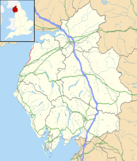
Allerdale is a non-metropolitan district of Cumbria, England, with borough status. Its council is based in Workington and the borough has a population of 93,492 according to the 2001 census, increasing to 96,422 at the 2011 Census.

Maryport is a town and civil parish in the Allerdale borough of Cumbria, England, historically in Cumberland.
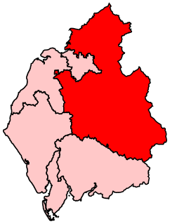
Penrith and The Border is a constituency in Cumbria represented in the House of Commons of the UK Parliament since 2019 by Neil Hudson, a Conservative.

Allonby is a village on the coast of the Allerdale district in Cumbria, England. The village is on the B5300 road 5 miles (8.0 km) north of Maryport and 8 miles (13
Bothel and Threapland is a civil parish in the Allerdale district of Cumbria, England, just outside the Lake District National Park. According to the 2001 census, it had a population of 438. The parish includes the villages of Bothel and Threapland. The village of Bothel is south-east of the parish of Aspatria and Threapland is south of Aspatria and Carlisle is eighteen miles (29 km) North-east of the parish. It had a population of 483 in the 2011 census figures.

Blitterlees is a small hamlet in the parish of Holme Low, one mile south of Silloth in Cumbria, United Kingdom. The hamlet of Wolsty is located approximately 1 mile (1.6 km) to the south as the crow flies, or 2.25 miles (3.62 km) by road, and Cumbria's county town, Carlisle, is located 23 miles (37 km) to the east. The B5300, known locally as the "coast road", runs through the village on its way to Beckfoot, Mawbray, Allonby, and ultimately Maryport.

Salta is a hamlet in the parish of Holme St Cuthbert in northwestern Cumbria, United Kingdom. It is 1.1 miles (1.8 km) southwest of the village of Mawbray, and 25.1 miles (40.4 km) southwest of the city of Carlisle. It has a population of about 35 people.

Gilcrux is a small village and civil parish in the ceremonial county of Cumbria, England, and historically part of Cumberland. It is situated just outside the Lake District National Park.
The B5300 is a B road which runs for approximately twelve miles between the towns of Silloth and Maryport in the Allerdale borough of Cumbria, United Kingdom. From north to south, it passes through the villages of Blitterlees, Beckfoot, Mawbray, Dubmill, and Allonby. It runs through the Solway Coast Area of Outstanding Natural Beauty, passes close to the Salta Moss Site of Special Scientific Interest, Milefortlet 21, a Roman archaeological site, the salt pans, a remnant of the Solway plain's medieval saltmaking industry, and the village of Crosscanonby. It is an important route for carrying goods to and from Silloth docks and Maryport harbour. It is also the major road connecting smaller coastal settlements with Maryport and Silloth, from where other roads lead to Workington, Whitehaven, Wigton, and Carlisle. A short section of the road between Dubmill and Mawbray was closed in February 2019 due to coastal erosion, and reopened in June 2019.

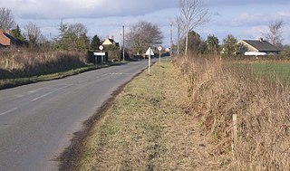
Crosby Villa is a hamlet in the civil parish of Crosscanonby in Cumbria, United Kingdom. It is located on the A596 road, 3.75 miles (6.04 km) north-east of Maryport and 3.75 miles (6.04 km) south-west of Aspatria. The village of Crosby is 1.5 miles (2.4 km) to the south-west, and the hamlet of Oughterside is 2.25 miles (3.62 km) to the north-east. Cumbria's county town, Carlisle, is 24 miles (39 km) to the north-east.

Holme St. Cuthbert is a small village and civil parish in the borough of Allerdale, in the county of Cumbria, United Kingdom. The village is located approximately 23 miles to the south-west of Carlisle, Cumbria's county town, and was historically in the county of Cumberland.

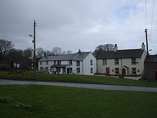
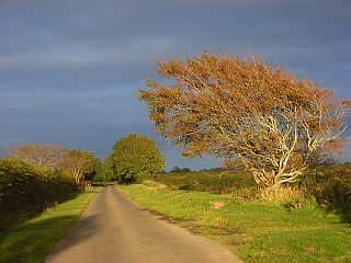
Westnewton is a small village and civil parish in the Allerdale district, in the county of Cumbria, England. The 2011 census had a population of 265. The village of Westnewton is situated to the north-west of the Lake District, on the relatively flat plain halfway between the Lake District hills and the Solway Firth. It is a small village located two miles north of Aspatria, on the B5301 Aspatria and Silloth road. The small hamlet of New Cowper is located one-and-a-half miles to the north-west. The landscape generally in this area is one of gently undulating fields, relatively devoid of features other than the thorn field-hedges, with shallow valleys carrying small streams, such as the Black Dub beck. Westnewton has a school called St Matthew's Church of England School, a church called St Matthew's Church, and a cemetery. There used to be a public house called the Swan Inn but this has closed.

Hayton is a village in Allerdale district, Cumbria, England. It is the only settlement in the civil parish of Hayton and Mealo. Historically located in Cumberland, and on a minor road between the B5300 and the A596, it is approximately 2 miles from the coast. Nearby settlements include the town of Aspatria and the villages of Oughterside and Prospect. A small tributary called Patten Beck runs across the village, through the grounds of the castle.

Oughterside is a village in the Allerdale district of the English county of Cumbria. Nearby settlements include the town of Aspatria and the villages of Hayton and Prospect. For transport there is the A596 road nearby. Oughterside is 2.1 miles away from Aspatria and is 6 miles from Cockermouth, the birthplace of William Wordsworth. Carlisle is the closest city to Oughterside that offers transport links to other locations across the UK through the railway network. Oughterside is located on the North Western edge of the Lake District.
Holme Low is a civil parish in the Allerdale borough of Cumbria, United Kingdom. It borders the parishes of Holme St. Cuthbert and Holme Abbey to the south, the town of Silloth-on-Solway to the north-west, and has a short stretch of coastline on the Solway Firth to the west. To the north, it is bordered by lands common to Holme St. Cuthbert, Holme Low, and Holme Abbey, which is an unpopulated area. Holme Low had a population of 373 in 137 households at the 2001 census, reducing slightly in the 2011 Census to a population of 362 in 162 households.
St James Church, Hayton, Cumbria is an active Anglican parish church in the deanery of Solway, the archdeaconry of West Cumberland and the diocese of Carlisle. The church dates from the 19th century.
Holme East Waver is a civil parish in the Allerdale borough of Cumbria, United Kingdom. It is bordered to the north by the civil parish of Bowness-on-Solway, to the east by the civil parishes of Kirkbride, Woodside, and Waverton, and to the south by the civil parishes of Dundraw and Holme Abbey, lands common to Holme St. Cuthbert, Holme Low, and Holme Abbey, and the town of Silloth-on-Solway. At the 2001 census, it had a population of 306 in 121 households, increasing slightly at the 2011 Census to a population of 318 in 130 households. It is named for the River Waver, and the rivers Waver and Wampool enter the Solway Firth at the western end of the parish. Part of the Solway Coast Area of Outstanding Natural Beauty is within the parish of Holme East Waver. The largest village is Newton Arlosh.

Oughterside and Allerby is a civil parish in Allerdale district, Cumbria, England. In the 2011 census it had a population of 619. The north western boundary of the parish is a short stretch of coast, then, working clockwise, the parish is bordered by Hayton and Mealo to the north, Aspatria to the north east, Plumbland to the south east, Gilcrux to the south and Crosscanonby to the south west. The A596 road from Aspatria to Maryport passes through the parish, and the B5300 road follows its coastline in the north west. The main settlements in the parish are Allerby in the west and Oughterside and Prospect, in the east.
Woodside is a civil parish in Allerdale district, Cumbria, England. At the 2011 census it had a population of 516.
