Helena Valley Southeast, Montana

Last updated

Helena Valley Southeast, Montana
Lewis and Clark County Montana Incorporated and Unincorporated areas Helena Valley Southeast Highlighted.svg
Location of Helena Valley Southeast, Montana
Coordinates: 46°36′41″N111°55′24″W / 46.61139°N 111.92333°W / 46.61139; -111.92333
Country United States
State Montana
County Lewis and Clark
Area
[1]
  Total22.41 sq mi (58.04 km2)
  Land21.47 sq mi (55.61 km2)
  Water0.94 sq mi (2.44 km2)
Elevation
3,810 ft (1,160 m)
Population
 (2020)
  Total9,168
  Density427.01/sq mi (164.87/km2)
Time zone UTC-7 (Mountain (MST))
  Summer (DST) UTC-6 (MDT)
Area code 406
FIPS code 30-35634

Helena Valley Southeast is a census-designated place (CDP) in Lewis and Clark County, Montana, United States. The population was 8,227 at the 2010 census. [2] It is part of the Helena Micropolitan Statistical Area.

Contents

Geography

Helena Valley Southeast is located in southern Lewis and Clark County at 46°36′41″N111°55′24″W / 46.61139°N 111.92333°W / 46.61139; -111.92333 (46.611392, -111.923425). [3] It is bordered to the southwest by the city of Helena, the state capital, and to the south by the city of East Helena. To the north it is bordered by the Helena Valley Northeast CDP.

Canyon Ferry Road is the main east-west street through the community. Downtown Helena is approximately 7 miles (11 km) southwest of the center of the CDP.

According to the United States Census Bureau, the CDP has a total area of 14.4 square miles (37.2 km2), of which 0.04 square miles (0.1 km2), or 0.37%, is water. [4]

Demographics

Historical population
CensusPop.Note
2020 9,168
U.S. Decennial Census [5]

As of the census [6] of 2000, there were 7,141 people, 2,495 households, and 1,941 families residing in the CDP. The population density was 441.4 inhabitants per square mile (170.4/km2). There were 2,590 housing units at an average density of 160.1 per square mile (61.8/km2). The racial makeup of the CDP was 93.60% White, 0.27% African American, 2.86% Native American, 0.38% Asian, 0.01% Pacific Islander, 0.49% from other races, and 2.39% from two or more races. Hispanic or Latino of any race were 1.93% of the population.

There were 2,495 households, out of which 47.9% had children under the age of 18 living with them, 59.5% were married couples living together, 12.8% had a female householder with no husband present, and 22.2% were non-families. 16.6% of all households were made up of individuals, and 4.1% had someone living alone who was 65 years of age or older. The average household size was 2.86 and the average family size was 3.23.

In the CDP, the population was spread out, with 34.4% under the age of 18, 7.1% from 18 to 24, 33.7% from 25 to 44, 19.5% from 45 to 64, and 5.4% who were 65 years of age or older. The median age was 31 years. For every 100 females, there were 99.6 males. For every 100 females age 18 and over, there were 96.9 males.

The median income for a household in the CDP was $38,147, and the median income for a family was $41,993. Males had a median income of $32,343 versus $21,112 for females. The per capita income for the CDP was $14,349. About 5.6% of families and 7.4% of the population were below the poverty line, including 9.4% of those under age 18 and 5.9% of those age 65 or over.

Education

For the north and west portions, Helena Elementary School District and Helena High School District are the respective school districts. The south and east portions are covered by a unified K-12 school district, East Helena K-12. [7]

Related Research Articles

<span class="mw-page-title-main">Tortolita, Arizona</span> Former CDP in Arizona, United States

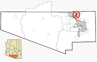
Tortolita was a census-designated place (CDP) in Pima County, Arizona, United States. The population was 3,740 at the 2000 census. Tortolita was situated between the growing incorporated towns of Oro Valley and Marana with most of the area previously part of the CDP having been annexed by the two towns during the 2000s. The remaining parts of the CDP that have not been annexed continue to be unincorporated portions of Pima County.

<span class="mw-page-title-main">Radersburg, Montana</span> Village in Montana, United States

Radersburg is an unincorporated rural village in Broadwater County, Montana, United States.

<span class="mw-page-title-main">Toston, Montana</span> Census-designated place in Montana, United States

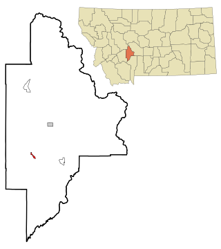
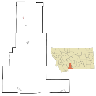
Toston is a census-designated place (CDP) in Broadwater County, Montana, United States. The population was 108 at the 2010 census.

<span class="mw-page-title-main">Winston, Montana</span> Census-designated place in Montana, United States

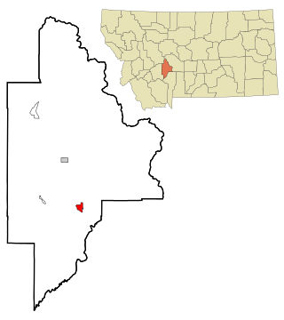
Winston is a census-designated place (CDP) in Broadwater County, Montana, United States. The population was 147 at the 2010 census.

<span class="mw-page-title-main">Fort Shaw, Montana</span> CDP in Montana, United States

Fort Shaw is a census-designated place (CDP) in Cascade County, Montana, United States. The population was 280 at the 2010 census. Named for a former United States military outpost, it is part of the Great Falls, Montana Metropolitan Statistical Area.

<span class="mw-page-title-main">Simms, Montana</span> CDP in Montana, United States

Simms is a census-designated place (CDP) in Cascade County, Montana, United States. The population was 354 at the 2010 census. It is part of the Great Falls, Montana Metropolitan Statistical Area.

<span class="mw-page-title-main">Willow Creek, Montana</span> Census-designated place in Gallatin County, Montana, United States.

Willow Creek is a census-designated place (CDP) in Gallatin County, Montana, United States. The population was 210 at the 2010 census. It is part of the Bozeman, MT Micropolitan Statistical Area.

<span class="mw-page-title-main">Jefferson City, Montana</span> Census-designated place in Montana, United States

Jefferson City is an unincorporated community and census-designated place (CDP) in Jefferson County, Montana, United States. The population was 472 at the 2010 census. It is part of the Helena Micropolitan Statistical Area.

<span class="mw-page-title-main">Augusta, Montana</span> Census-designated place in Montana, United States

Augusta is an unincorporated community and census-designated place (CDP) in Lewis and Clark County, Montana, United States. The population was 309 at the 2010 census and rose to 316 in the 2020 census. The most accepted version in the naming of this town is after Augusta Hogan, thought to be the first child born in this town, the daughter of J. D. Hogan, an early rancher.

<span class="mw-page-title-main">Helena Valley Northeast, Montana</span> Census-designated place in Montana, United States

Helena Valley Northeast is a census-designated place (CDP) in Lewis and Clark County, Montana, United States. The population was 2,995 at the 2010 census. It is part of the Helena Micropolitan Statistical Area.

<span class="mw-page-title-main">Helena Valley Northwest, Montana</span> CDP in Montana, United States

Helena Valley Northwest is a census-designated place (CDP) in Lewis and Clark County, Montana, United States. The population was 3,482 at the 2010 census. It is part of the Helena Micropolitan Statistical Area.

<span class="mw-page-title-main">Helena Valley West Central, Montana</span> Census-designated place in Montana, United States

Helena Valley West Central is a census-designated place (CDP) in Lewis and Clark County, Montana, United States. The population was 7,883 at the 2010 census. It is part of the Helena Micropolitan Statistical Area.

<span class="mw-page-title-main">Lincoln, Montana</span> Census-designated place in Montana, United States

Lincoln is an unincorporated community and census-designated place (CDP) in Lewis and Clark County, Montana, United States. As of the 2010 census, the population was 1,013.

<span class="mw-page-title-main">Clinton, Montana</span> CDP in Montana, United States

Clinton is a census-designated place (CDP) in Missoula County, Montana, United States. It is part of the 'Missoula, Montana Metropolitan Statistical Area'. The CDP was named for General Sir Henry Clinton. The population was 1,052 at the 2010 census, an increase from its population of 549 in 2000.

<span class="mw-page-title-main">East Missoula, Montana</span> CDP in Montana, United States

East Missoula is a census-designated place (CDP) in Missoula County, Montana, United States. It is part of the Missoula, Montana Metropolitan Statistical Area'. The population was 2,157 at the 2010 census, an increase from its population of 2,070 in 2000.

<span class="mw-page-title-main">Wilsall, Montana</span> CDP in Montana, United States

Wilsall is a census-designated place (CDP) in Park County, Montana, United States. The population was 237 at the 2000 census.

<span class="mw-page-title-main">Garrison, Montana</span> CDP in Montana, United States

Garrison is a census-designated place (CDP) in Powell County, Montana, United States. The population was 112 at the 2000 census.

<span class="mw-page-title-main">Clancy, Montana</span> Census-designated place in Montana, United States

Clancy is an unincorporated community and census-designated place (CDP) in Jefferson County, Montana, United States. The population was 1,661 at the 2010 census, up from 1,406 in 2000. It is part of the Helena Micropolitan Statistical Area.

<span class="mw-page-title-main">Helena West Side, Montana</span> Census-designated place in Montana, United States

Helena West Side is a census-designated place (CDP) in Lewis and Clark County, Montana, United States. The population was 1,637 at the 2010 census, down from 1,711 at the 2000 census due to annexation of part of the CDP by the city of Helena. It is part of the Helena Micropolitan Statistical Area.

<span class="mw-page-title-main">Power, Montana</span> CDP in Montana, United States

Power is a census-designated place (CDP) in Teton County, Montana, United States. The population was 171 at the 2000 census. The town is named after Montana pioneer, Thomas Charles Power, who platted the townsite in 1910.

References

  1. "ArcGIS REST Services Directory". United States Census Bureau. Retrieved September 5, 2022.
  2. "Total Population: 2010 Census DEC Summary File 1 (P1), Helena Valley Southeast CDP, Montana". data.census.gov. U.S. Census Bureau. Retrieved April 27, 2020.
  3. "US Gazetteer files: 2010, 2000, and 1990". United States Census Bureau. February 12, 2011. Retrieved April 23, 2011.
  4. "U.S. Gazetteer Files: 2019: Places: Montana". U.S. Census Bureau Geography Division. Retrieved April 27, 2020.
  5. "Census of Population and Housing". Census.gov. Retrieved June 4, 2016.
  6. "U.S. Census website". United States Census Bureau . Retrieved January 31, 2008.
  7. "2020 CENSUS - SCHOOL DISTRICT REFERENCE MAP: Lewis and Clark County, MT" (PDF). U.S. Census Bureau . Retrieved March 14, 2024.