Lincoln, Montana

Last updated

Lincoln, Montana
Lincoln, Montana 01.JPG
Downtown Lincoln in the winter
Lewis and Clark County Montana Incorporated and Unincorporated areas Lincoln Highlighted.svg
USA Montana location map.svg
Red pog.svg
Lincoln
Location in Montana
Usa edcp location map.svg
Red pog.svg
Lincoln
Location in the United States
Coordinates: 46°57′28″N112°40′20″W / 46.95778°N 112.67222°W / 46.95778; -112.67222
Country Flag of the United States (23px).png  United States
State Flag of Montana.svg  Montana
County Lewis and Clark
Area
[1]
  Total18.06 sq mi (46.79 km2)
  Land17.55 sq mi (45.44 km2)
  Water0.52 sq mi (1.34 km2)
Elevation
4,541 ft (1,384 m)
Population
 (2020)
  Total998
  Density56.88/sq mi (21.96/km2)
Time zone UTC−7 (Mountain (MST))
  Summer (DST) UTC−6 (MDT)
ZIP Code
59639
Area code 406
FIPS code 30-43675
GNIS feature ID0801064

Lincoln is an unincorporated community and census-designated place (CDP) in Lewis and Clark County, Montana, United States. As of the 2010 census, the population was 1,013. [2]

Contents

History

Meriwether Lewis passed through the area on his return to St. Louis in 1806, following the famous "River of the Road to the Buffalo" created by Native Americans centuries before. [3] Gold discoveries in the mid-1860s brought miners to a number of camps in the area, and Lincoln was eventually created when nearby Lincoln Gulch was abandoned in favor of the town's present location. Recreational, logging and mining activities along the Blackfoot River in the early 20th century made it a convenient commercial center. Nearby wilderness areas continue to attract visitors and residents.

The Lincoln Community Hall (1918) and the Hotel Lincoln (1914) are listed on the National Register of Historical Places.

"Unabomber" arrest

Unabomber Ted Kaczynski is escorted out of a cabin raided by the FBI during their investigation on April 3, 1996 Tk arrest.jpg
Unabomber Ted Kaczynski is escorted out of a cabin raided by the FBI during their investigation on April 3, 1996

On April 3, 1996, federal officers arrested Ted Kaczynski at his remote cabin 5 miles (8 km) south of Lincoln on Stemple Pass Road, under suspicion of being the "Unabomber", a domestic terrorist who placed pressure-sensitive bombs inside mailed packages. [4] The bombing campaign resulted in three deaths and 23 wounded. Kaczynski was sentenced to eight life sentences without the possibility of parole. He died at FMC Butner Prison in North Carolina on June 10, 2023.

2017 earthquake

At 12:30 a.m. on July 6, 2017, there was a 5.8-magnitude earthquake about 6 miles (10 km) south of Lincoln. [5] [6] [7] The earthquake originated from a depth of nearly 3 miles (5 km) underground, [6] near a fault system known as the Lewis and Clark line, which runs 250 miles (400 km) from northern Idaho to east of Helena, Montana. [8] It was the eighth-strongest earthquake recorded in Montana. [9] There were at least nine more tremors nearby within the first hour after the earthquake, with magnitudes between 3.1 and 4.9. [6]

Geography and climate

Lincoln is located in western Lewis and Clark County at 46°57′28″N112°40′20″W / 46.957713°N 112.672178°W / 46.957713; -112.672178 (46.957713, -112.672178). [10] The CDP contains the unincorporated center of Lincoln and extends 6 miles (10 km) east up the Blackfoot River valley and 3 miles (5 km) west, or down valley. Its elevation is 4,536 feet (1,383 m) above sea level. According to the United States Census Bureau, the CDP has a total area of 18.1 square miles (46.8 km2), of which 17.5 square miles (45.4 km2) are land and 0.50 square miles (1.3 km2), or 2.87%, are water. [11]

Lincoln is located on Montana Highway 200, the longest route signed as a state highway in the United States, running 706.6 miles (1,137.2 km) from Idaho to North Dakota. From Lincoln, the highway runs northeast up and over the Continental Divide 87 miles (140 km) to Great Falls and west 77 miles (124 km) to Missoula.

Lincoln has a humid continental climate (Dfb) bordering closely on a subarctic climate (Dfc). Summers are warm to hot while winters are cold and snowy, with annual average snowfall totaling 85.4 inches (217 cm). [12]

Rogers Pass, 18 miles (29 km) northeast of Lincoln on Highway 200, is known for being the location of the coldest recorded temperature in the United States outside of Alaska. On January 20, 1954, a temperature of −70 °F (−57 °C) was recorded. Lincoln has a humid continental climate bordering on semi-arid. Snow is usually dry powder, although strong Pacific Ocean storms sometimes bring moisture-laden snow to the area. [13] Some sources list Lincoln as having November's record low of −53 °F (−47 °C), but that never happened, Lincoln's real November record low is −45 °F (−43 °C) .

Climate data for Lincoln, Montana, 1991–2020 normals, extremes 1948–2012
MonthJanFebMarAprMayJunJulAugSepOctNovDecYear
Record high °F (°C)59
(15)
60
(16)
72
(22)
84
(29)
92
(33)
94
(34)
102
(39)
102
(39)
98
(37)
84
(29)
68
(20)
55
(13)
102
(39)
Mean maximum °F (°C)47.1
(8.4)
50.3
(10.2)
60.1
(15.6)
72.6
(22.6)
81.0
(27.2)
87.1
(30.6)
93.3
(34.1)
92.5
(33.6)
86.1
(30.1)
73.7
(23.2)
56.6
(13.7)
44.9
(7.2)
94.9
(34.9)
Mean daily maximum °F (°C)31.7
(−0.2)
34.7
(1.5)
43.9
(6.6)
52.6
(11.4)
62.5
(16.9)
71.1
(21.7)
81.3
(27.4)
81.1
(27.3)
70.2
(21.2)
54.4
(12.4)
38.9
(3.8)
30.5
(−0.8)
54.4
(12.4)
Daily mean °F (°C)22.0
(−5.6)
25.1
(−3.8)
32.8
(0.4)
39.7
(4.3)
47.9
(8.8)
55.6
(13.1)
62.6
(17.0)
61.4
(16.3)
52.8
(11.6)
41.5
(5.3)
29.5
(−1.4)
21.6
(−5.8)
41.0
(5.0)
Mean daily minimum °F (°C)12.3
(−10.9)
15.4
(−9.2)
21.7
(−5.7)
26.8
(−2.9)
33.2
(0.7)
40.1
(4.5)
43.8
(6.6)
41.6
(5.3)
35.4
(1.9)
28.5
(−1.9)
20.0
(−6.7)
12.8
(−10.7)
27.6
(−2.4)
Mean minimum °F (°C)−17.4
(−27.4)
−14.6
(−25.9)
−1.7
(−18.7)
13.6
(−10.2)
21.6
(−5.8)
28.9
(−1.7)
33.4
(0.8)
29.7
(−1.3)
21.2
(−6.0)
9.1
(−12.7)
−3.5
(−19.7)
−16.0
(−26.7)
−28.3
(−33.5)
Record low °F (°C)−48
(−44)
−44
(−42)
−34
(−37)
−8
(−22)
8
(−13)
19
(−7)
24
(−4)
21
(−6)
6
(−14)
−13
(−25)
−45
(−43)
−48
(−44)
−48
(−44)
Average precipitation inches (mm)1.49
(38)
2.30
(58)
1.25
(32)
1.46
(37)
1.99
(51)
2.62
(67)
0.82
(21)
1.04
(26)
1.33
(34)
1.63
(41)
1.35
(34)
1.49
(38)
18.77
(477)
Average snowfall inches (cm)15.1
(38)
10.0
(25)
7.4
(19)
3.2
(8.1)
1.1
(2.8)
1.2
(3.0)
0.0
(0.0)
0.0
(0.0)
0.5
(1.3)
2.1
(5.3)
9.5
(24)
16.5
(42)
66.6
(168.5)
Average extreme snow depth inches (cm)12.4
(31)
12.1
(31)
10.1
(26)
4.3
(11)
0.9
(2.3)
0.4
(1.0)
0.0
(0.0)
0.0
(0.0)
0.2
(0.51)
1.2
(3.0)
4.5
(11)
9.6
(24)
17.0
(43)
Average precipitation days (≥ 0.01 in)9.08.39.38.811.012.37.46.66.98.58.68.1104.8
Average snowy days (≥ 0.1 in)6.15.04.41.50.40.20.00.00.11.04.76.730.1
Source 1: NOAA [14] [15]
Source 2: National Weather Service (mean maxima/minima, snow/snow days/snow depth 19812010) [16]

Demographics

Historical population
CensusPop.Note
2000 1,100
2010 1,013−7.9%
2020 998−1.5%
U.S. Decennial Census

As of the census [17] of 2010, there were 1,013 people, 507 households, and 296 families residing in the CDP. The population density was 56.6 inhabitants per square mile (21.9/km2). There were 846 housing units at an average density of 47.3 per square mile (18.3/km2). The racial makeup of the CDP was 95.5% White, 2.2% Native American, 0.2% Asian, and 1.9% from two or more races. Hispanic or Latino of any race were 1.5% of the population.

There were 507 households, out of which 16.6% had children under the age of 18 living with them, 48.3% were married couples living together, 6.7% had a female householder with no husband present, and 41.6% were non-families. 18.5% of all households were made up of individuals, and 33.9% had someone living alone who was 65 years of age or older. The average household size was 2.00 and the average family size was 2.55.

In the CDP, the population was spread out, with 16.3% under the age of 18, 3.7% from 18 to 24, 16.1% from 25 to 44, 41.2% from 45 to 64, and 22.8% who were 65 years of age or older. The median age was 53 years. For every 100 females, there were 108.4 males. For every 100 females age 18 and over, there were 107.3 males.

The median income for a household in the CDP was $26,688, and the median income for a family was $32,784. Males had a median income of $24,583 versus $15,227 for females. The per capita income for the CDP was $14,243. About 17.4% of families and 21.2% of the population were below the poverty line, including 28.8% of those under age 18 and 9.8% of those age 65 or over.

Infrastructure

Lincoln Airport is a public use airport located two miles (4 km) east of town.

Education

Public education in Lincoln is administered by Lincoln Public School District #38, [18] a unified PK-12 school district The district educates students from kindergarten to 12th grade. [19] Lincoln High School's team name is the Lynx.

Lincoln has a public library, a branch of the Lewis & Clark Library. [20]

Nearby Bugle Mountain (also known as "Bugle Peak"), located in the Scapegoat Wilderness, was the setting of a forest fire in the fictional 1952 motion picture Red Skies of Montana , based in part on the tragic 1949 Mann Gulch fire and filmed in Montana.

Media

The Blackfoot Valley Dispatch is an online newspaper in Lincoln. [21] The town receives radio stations from the wider Helena area.

Notable people

See also

Related Research Articles

<span class="mw-page-title-main">Lewis and Clark County, Montana</span> County in Montana, United States

Lewis and Clark County is a county located in the U.S. state of Montana. As of the 2020 census, the population was 70,973. Its county seat is Helena, the state capital. The numerical designation for Lewis and Clark County is 5. The county was established on June 2, 1865, as one of the nine original counties of the Territory of Montana named Edgerton County in honor of Sidney Edgerton, first Governor of the Territory of Montana, and was renamed Lewis and Clark County on March 1, 1868, in honor of explorers Meriwether Lewis and William Clark.

<span class="mw-page-title-main">Chouteau County, Montana</span> County in Montana, United States

Chouteau County is a county located in the North-Central region of the U.S. state of Montana. As of the 2020 census, the population was 5,895. Its county seat is Fort Benton. The county was established in 1865 as one of the original nine counties of Montana, and named in 1882 after Pierre Chouteau Jr., a fur trader who established a trading post that became Fort Benton, which was once an important port on the Missouri River.

<span class="mw-page-title-main">Pryor, Montana</span> Census-designated place in Montana, United States

Pryor is a census-designated place (CDP) in Big Horn County, Montana, United States. The community is located on Crow Tribe's reservation. The population was 618 at the 2010 census. The area is named for Nathaniel Hale Pryor, a sergeant in the Lewis and Clark Expedition.

<span class="mw-page-title-main">Black Eagle, Montana</span> CDP in Montana, United States

Black Eagle is a census-designated place (CDP) in Cascade County, Montana, United States. The population was 904 at the 2010 census. It is a suburb of Great Falls.

<span class="mw-page-title-main">Simms, Montana</span> CDP in Montana, United States

Simms is a census-designated place (CDP) in Cascade County, Montana, United States. The population was 354 at the 2010 census. It is part of the Great Falls, Montana Metropolitan Statistical Area.

<span class="mw-page-title-main">Montana City, Montana</span> Census-designated place in Montana, United States

Montana City is an unincorporated community and census-designated place (CDP) in Jefferson County, Montana, United States. The population was 2,715 at the 2010 census, up from 2,094 in 2000. It is part of the Helena Micropolitan Statistical Area.

<span class="mw-page-title-main">Augusta, Montana</span> Census-designated place in Montana, United States

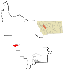
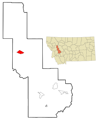
Augusta is an unincorporated community and census-designated place (CDP) in Lewis and Clark County, Montana, United States. The population was 309 at the 2010 census and rose to 316 in the 2020 census. The most accepted version in the naming of this town is after Augusta Hogan, thought to be the first child born in this town, the daughter of J. D. Hogan, an early rancher.

<span class="mw-page-title-main">East Helena, Montana</span> City in Montana, United States

East Helena is a city in Lewis and Clark County, Montana, United States, approximately 5 miles (8 km) east of downtown Helena. The population was 1,944 at the 2020 census. It is part of the Helena Micropolitan Statistical Area, which includes all of Lewis and Clark and Jefferson counties; its population is 83,058 according to the 2020 Census.

<span class="mw-page-title-main">Helena Valley Northeast, Montana</span> Census-designated place in Montana, United States

Helena Valley Northeast is a census-designated place (CDP) in Lewis and Clark County, Montana, United States. The population was 2,995 at the 2010 census. It is part of the Helena Micropolitan Statistical Area.

<span class="mw-page-title-main">Helena Valley Northwest, Montana</span> CDP in Montana, United States

Helena Valley Northwest is a census-designated place (CDP) in Lewis and Clark County, Montana, United States. The population was 3,482 at the 2010 census. It is part of the Helena Micropolitan Statistical Area.

<span class="mw-page-title-main">Helena Valley Southeast, Montana</span> Census-designated place in Montana, United States

Helena Valley Southeast is a census-designated place (CDP) in Lewis and Clark County, Montana, United States. The population was 8,227 at the 2010 census. It is part of the Helena Micropolitan Statistical Area.

<span class="mw-page-title-main">Helena Valley West Central, Montana</span> Census-designated place in Montana, United States

Helena Valley West Central is a census-designated place (CDP) in Lewis and Clark County, Montana, United States. The population was 7,883 at the 2010 census. It is part of the Helena Micropolitan Statistical Area.

<span class="mw-page-title-main">St. Regis, Montana</span> Census-designated place in Montana, United States

St. Regis or Saint Regis is an unincorporated community and census-designated place (CDP) in Mineral County, Montana. The population was 313 at the time of the 2020 census.

<span class="mw-page-title-main">Bonner-West Riverside, Montana</span> CDP in Montana, United States

Bonner-West Riverside is a census-designated place (CDP) in Missoula County, Montana, United States, including the unincorporated communities of Bonner, Milltown, West Riverside, and Pinegrove. It is part of the Missoula, Montana Metropolitan Statistical Area. The population was 1,663 at the 2010 census, a decline from its population of 1,693 in 2000.

<span class="mw-page-title-main">Lolo, Montana</span> CDP in Montana, United States

Lolo is a census-designated place (CDP) in Missoula County, Montana, United States. It is part of the Missoula Metropolitan Statistical Area. The population was 4,399 at the 2020 census, an increase from its population of 3,892 in 2010. It is home to Travelers' Rest State Park, a site where Lewis and Clark camped in 1805 and again in 1806.

<span class="mw-page-title-main">Wilsall, Montana</span> CDP in Montana, United States

Wilsall is a census-designated place (CDP) in Park County, Montana, United States. The population was 237 at the 2000 census.

<span class="mw-page-title-main">Ovando, Montana</span> CDP in Montana, United States

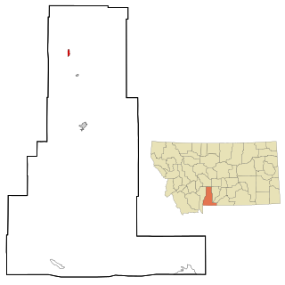
Ovando is a census-designated place (CDP) in Powell County, Montana, United States. It is approximately fifty-four miles ENE of Missoula, Montana. The population was 71 at the 2000 census.

<span class="mw-page-title-main">Cardwell, Montana</span> Census-designated place in Montana, United States

Cardwell is a census-designated place (CDP) in Jefferson County, Montana, United States. The population was 62 at the 2020 census. It is part of the Helena Micropolitan Statistical Area.

<span class="mw-page-title-main">Clancy, Montana</span> Census-designated place in Montana, United States

Clancy is an unincorporated community and census-designated place (CDP) in Jefferson County, Montana, United States. The population was 1,661 at the 2010 census, up from 1,406 in 2000. It is part of the Helena Micropolitan Statistical Area.

<span class="mw-page-title-main">Helena West Side, Montana</span> Census-designated place in Montana, United States

Helena West Side is a census-designated place (CDP) in Lewis and Clark County, Montana, United States. The population was 1,637 at the 2010 census, down from 1,711 at the 2000 census due to annexation of part of the CDP by the city of Helena. It is part of the Helena Micropolitan Statistical Area.

References

  1. "ArcGIS REST Services Directory". United States Census Bureau. Retrieved September 5, 2022.
  2. "Total Population: 2010 Census DEC Summary File 1 (P1), Lincoln CDP, Montana". data.census.gov. U.S. Census Bureau. Retrieved April 27, 2020.
  3. "Lincoln". Montana Place Names Companion. Montana Historical Society. Retrieved April 5, 2021.
  4. Hardy, Quentin; Carley, William M.; Davidson, Joe. "Unabomber suspect held in Montana". Wall Street Journal. April 4, 1996. p. A3.
  5. "Google Maps".
  6. 1 2 3 "5.8 magnitude earthquake rattles Helena area". Independent Record (Helena, Montana). July 6, 2017.
  7. "M 5.8 - 11km SSE of Lincoln, Montana". Earthquakes Hazard Program. United States Geological Survey. July 6, 2017.
  8. "Rare 5.8 earthquake strikes western Montana, the area's strongest temblor in nearly 60 years". Los Angeles Times. July 6, 2017.
  9. "Montana Earthquake: 5.8 Quake Strikes Outside Lincoln". Associated Press . NBC News. July 6, 2017.
  10. "US Gazetteer files: 2010, 2000, and 1990". United States Census Bureau. February 12, 2011. Retrieved April 23, 2011.
  11. "U.S. Gazetteer Files: 2019: Places: Montana". U.S. Census Bureau Geography Division. Retrieved April 27, 2020.
  12. "LINCOLN RANGER STN, MONTANA - Climate Summary". wrcc.dri.edu. Retrieved May 28, 2020.
  13. "This is Montana". www.umt.edu. Retrieved April 22, 2021.
  14. "U.S. Climate Normals Quick Access – Station: Lincoln RS, MT (19912020)". National Oceanic and Atmospheric Administration. Retrieved February 22, 2023.
  15. "U.S. Climate Normals Quick Access – Station: Lincoln Ranger Station, MT (19812010)". National Oceanic and Atmospheric Administration. Retrieved February 22, 2023.
  16. "NOAA Online Weather Data – NWS Great Falls". National Weather Service. Retrieved February 22, 2023.
  17. "American FactFinder". United States Census Bureau. Archived from the original on February 14, 2020. Retrieved December 29, 2017.
  18. "2020 CENSUS - SCHOOL DISTRICT REFERENCE MAP: Lewis and Clark County, MT" (PDF). U.S. Census Bureau . Retrieved March 14, 2024.
  19. "Homepage". Lincoln Public Schools. Retrieved June 14, 2019.
  20. "Montana Public Libraries". PublicLibraries.com. Retrieved June 14, 2019.
  21. "News". Blackfoot Valley Dispatch. Retrieved August 23, 2023.