Hepworth, West Yorkshire

Last updated

Hepworth
Hepworth Holmfirth Kirklees (RLH).JPG
View of Hepworth from Tenter Hill
West Yorkshire UK location map.svg
Red pog.svg
Hepworth
Location within West Yorkshire
OS grid reference SE163067
Civil parish
Metropolitan borough
Metropolitan county
Region
Country England
Sovereign state United Kingdom
Post town HOLMFIRTH
Postcode district HD9
Police West Yorkshire
Fire West Yorkshire
Ambulance Yorkshire
UK Parliament
List of places
UK
England
Yorkshire
53°33′25″N1°45′16″W / 53.556900°N 1.754400°W / 53.556900; -1.754400

Hepworth is a village and former civil parish, now in the parish of Holme Valley, in the metropolitan borough of Kirklees, in West Yorkshire, England. It is southeast of Holmfirth and southwest of Jackson Bridge. In 1931 the parish had a population of 840. [1]

Contents

Although it started as a fairly small hamlet it has grown considerably through the 1980s and 1990s with new housing and small businesses. It has been extensively used as one of the locations in the BBC's long-running comedy series Last of the Summer Wine , much of which has centred on the village pub the 'Butchers Arms', which provides a central meeting place for the village residents.

History

Toponymy

The name Hepworth is Anglo-Saxon. H. T. Moorhouse states, in his History of Kirkburton and the Graveship of Holme (1861), that the name is derived from the Anglo-Saxon “Hep” meaning high and “worth” meaning place of residence. The Oxford Dictionary of Place Names has –worth as meaning an enclosure, hence enclosure of a man called Heppa. [2] In the Domesday Book it is given the name Hepeuuord and is described as the King’s land with steep streets.

Early history

In medieval times the wool trade was the chief source of employment. During the fourteenth century Hepworth was in the parish of Kirkburton, which covered around fifty square miles. It incorporated the townships of Wooldale, Cumberworth, Cartworth, Fulstone, Shepley amongst others. In the fifteenth century a church was built at Holmfirth and during the Civil War a petition was submitted asking for Holmfirth to be made a parish in its own right. The petition was granted by Minister Gamaliel Abraham in 1651. Hepworth and its neighbour Scholes thus became part of the parish of Holmfirth.

The Great Plague

In 1665 – 1666 the Great Plague struck England. It wrought devastation in London, then spread across the country. Hepworth was the most northerly point that it reached. According to local legend it is supposed to have come in on cloth brought from London.

In an effort to save the village the residents split the village into two parts at Barracks Fold. Those that were infected remained, isolated from the world, in one half. Thirteen of the residents died from the disease, which was a considerable percentage of the population in such a small village and thirteen trees were planted to remember them. The trees still stand today, by the local football pitch. Two subsequently fell down and in 2004, replacements were planted at a small ceremony by Parish Councillor, Ruth Jackson. The end of the plague in Hepworth is still commemorated on the last Monday in June every year with Hepworth Feast.

Hepworth's spiritual founding

In 1777 a mighty storm caused the River Holme to swell and flood over its banks in Holmfirth, sweeping away people and property, including the parish church. It was rebuilt in its present state a year later with funding from local clothiers. During this period Wesleyan evangelicals were active in the Holme Valley and Hepworth. They encouraged the local residents to demand that church services be held at the Old Town School. This led to Hepworth becoming a separate parish. In 1863 Holy Trinity Church was consecrated by the Bishop of Ripon further boosting spirituality in Hepworth.

19th century

In 1822 Thomas Langdale recorded a population of 1,048 for the township of Hepworth. [3]

Civil parish

Hepworth was formerly a township and chapelry in the parish of Kirkburton, [4] from 1866 Hepworth was a civil parish in its own right, on 1 April 1938 the parish was abolished and merged with Holmfirth, part also went to form Dunford. [5]

Local village events

Hepworth has a range of events on a regular basis. They are mainly arranged by the Hepworth Community Association or the local church. These include:-

Hepworth Feast

Hepworth Feast is held every year on the last Monday of June. It commemorates the end of the 1665 Great Plague in Hepworth. Traditionally a pig is roasted and this is now done by The Butchers Arms pub during the evening family gathering in the village. During the afternoon a procession of villagers walk from Hepworth to Scholes and back, in a circular trip, accompanied by Hepworth Brass Band. The local school children are given a tea after the procession and in the evening the children take part in races at the Recreation Ground. Prior to 2004 the feast had degenerated into an event to get drunk at. However since then the Hepworth Feast Committee have sought to make the event more family oriented. They have introduced stalls for children on the main street, including some more traditional Punch and Judy, coconut-shies and magicians acts. There is also an exhibition of historical photographs from Hepworth in the Village Hall.

Hepworth Garden Trail

Hepworth Garden Trail is organised by Hepworth Church and held every two years during early July. Selected gardens in the village are opened to the public. Those that can be viewed are marked on a map of the village. Many of the gardens listed feature plant stalls or sell refreshments.

Hepworth Garden Show

Hepworth Garden Show is held annually on the first Saturday in September at the Village Hall. Fruit, vegetables and flowers are displayed and judged upstairs. Children’s exhibits, cookery and handicrafts are displayed and judged downstairs. After the show any exhibits left behind are auctioned off at the local Sports and Social Club.

Sport

The village football team Hepworth United compete in the Sheffield & Hallamshire County Senior Football League and play at Far Lane, just outside the village centre.

Location grid

The above grid is based on exact directions rather than close to.

Related Research Articles

<span class="mw-page-title-main">Holmfirth</span> Town in West Yorkshire, England

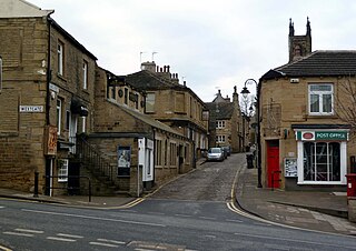
Holmfirth is a town in the Metropolitan Borough of Kirklees, West Yorkshire, England, on the A635 and A6024 in the Holme Valley, at the confluence of the River Holme and Ribble, 6 miles (9.7 km) south of Huddersfield and 14 miles (23 km) west of Barnsley. It mostly consists of stone-built cottages nestled on the eastern slopes of the Pennine hills. The boundary of the Peak District National Park is 2 miles (3.2 km) south-west of the town.

<span class="mw-page-title-main">Kirkburton</span> Village and civil parish in West Yorkshire, England

Kirkburton is a village, civil parish and ward in Kirklees in West Yorkshire, England. It is 5 miles (8 km) south-east of Huddersfield. Historically part of the West Riding of Yorkshire, the township comprised the villages of Kirkburton and Highburton and several hamlets, including Thunder Bridge, Thorncliffe, Storthes Hall and Linfit. According to the 2011 census the civil parish had a population of 26,439, while the village had a population of 4,299.

<span class="mw-page-title-main">Shelley, West Yorkshire</span> Village in West Yorkshire, England

Shelley is a village in the civil parish of Kirkburton, in the Kirklees district, in the county of West Yorkshire, England. The village is 3 miles (5 km) north of Holmfirth and 6 miles (10 km) south-east of Huddersfield.

<span class="mw-page-title-main">Honley</span> Village in West Yorkshire, England

Honley is a large village and former civil parish, now in the parish of Holme Valley, in the Kirklees district, in West Yorkshire, England. Historically part of the West Riding of Yorkshire, it is situated near to Holmfirth and Huddersfield, and on the banks of the River Holme in the Holme Valley. According to the 2011 Census it had a population of 6,474, a growth of 577 from the 2001 Census

<span class="mw-page-title-main">Upperthong</span> Village in West Yorkshire, England

Upperthong is a village approximately 807 feet (246 m) above sea level, near the town of Holmfirth in Holme Valley, approximately 7 miles (11 km) south of Huddersfield, West Yorkshire, England.

<span class="mw-page-title-main">New Mill, West Yorkshire</span> Village in West Yorkshire, England

New Mill, West Yorkshire, England, is a small, semi-rural village near the town of Holmfirth. It is in the metropolitan borough of Kirklees and the civil parish of Holme Valley. The village had a population of 1,259 in the 2001 census. The village is 2 miles (3.2 km) east of Holmfirth and 6 miles (9.7 km) south of Huddersfield.

<span class="mw-page-title-main">Holme-on-Spalding-Moor</span> Village and civil parish in the East Riding of Yorkshire, England

Holme-on-Spalding-Moor is a large village and civil parish in the East Riding of Yorkshire, England. It is situated approximately 7 miles (11 km) north-east of Howden and 5 miles (8 km) south-west of Market Weighton. It lies on the A163 road where it joins the A614 road.

<span class="mw-page-title-main">Lepton, West Yorkshire</span> Suburb of Huddersfield, West Yorkshire, England

Lepton is a village near Huddersfield in the parish of Kirkburton, in the Kirklees district of West Yorkshire, England. It is 4.25 miles (7 km) to the east of Huddersfield on the A642 road, 120 metres (390 ft) above the town centre directly north of Lepton Great Wood. In 1931 the parish had a population of 3,323.

<span class="mw-page-title-main">Holme, West Yorkshire</span> Village in West Yorkshire, England

Holme is a village and former civil parish, now in the parish of Holme Valley, in the Kirklees district, in the county of West Yorkshire, England. Between Holmbridge and Lane Village in West Yorkshire close to the border with Derbyshire. It is 2.5 miles (4 km) southwest of the town of Holmfirth and 9.7 miles (16 km) from Tintwistle on the edge of the Pennines. It lies on the boundary of the Peak District National Park, with some properties split to lie partially outside of it. In 1931 the parish had a population of 368.

<span class="mw-page-title-main">Shepley</span> Village in West Yorkshire, England

Shepley is a village in the civil parish of Kirkburton, in Kirklees, West Yorkshire, England, and in the Diocese of Wakefield. It lies 8 miles (13 km) south south east of Huddersfield and 6 miles (9.7 km) north west of Penistone.

<span class="mw-page-title-main">Flockton</span> Village in West Yorkshire, England

Flockton is a village in the civil parish of Kirkburton, in Kirklees, West Yorkshire, England. It is halfway between Huddersfield and Wakefield. It has a population of 1,410.

<span class="mw-page-title-main">Scholes, Holme Valley</span> Village in West Yorkshire, England

Scholes is a village and former civil parish, now in the parish of Holme Valley, in Kirklees, West Yorkshire, England. It is situated 1 mile (2 km) to the south-east and above Holmfirth, 7 miles (11 km) south-west of Huddersfield, in the Holme Valley. It has a population of 1,990. The name Scholes may have originated from the Scandinavian language meaning 'the temporary huts or sheds'.

<span class="mw-page-title-main">Thurstonland</span> Village in West Yorkshire, England

Thurstonland is a village in the civil parish of Kirkburton, in Kirklees, West Yorkshire, England. It has a population of almost 400.

<span class="mw-page-title-main">Netherthong</span> Village in West Yorkshire, England

Netherthong is a village and former civil parish, now in the parish of Holme Valley, and the metropolitan borough of Kirklees in West Yorkshire, England. The village is near the town of Holmfirth, and on the B6107 road to Meltham from the main A6024 Woodhead Road through the Holme Valley from Honley to Holmfirth. It has an estimated population of 1,738 (2018).

<span class="mw-page-title-main">Farnley Tyas</span> Village in West Yorkshire, England

Farnley Tyas is village in the parish of Kirkburton, in the Kirklees district, in the county of West Yorkshire, England 3 miles (4.8 km) south east of Huddersfield. It is located on a hilltop between Almondbury, Castle Hill, Thurstonland and Honley. It is mostly rural and farmland with private housing and some local authority social housing. In 1921 the parish had a population of 486.

Dunford is a civil parish in the Metropolitan Borough of Barnsley, 14.5 miles (23.3 km) northwest of Sheffield in South Yorkshire, England. It lies in the Peak District and within the Metropolitan Borough of Barnsley. The population of the civil parish as of the 2011 census was 568. The parish is centred on Dunford Bridge to the west and Lower Cumberworth to the east with Crow Edge virtually central between them.

<span class="mw-page-title-main">Church of St Thomas, Thurstonland</span> Church in West Yorkshire, England

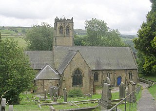
The Church of St Thomas, Thurstonland, West Yorkshire, England, is an Anglican church. It is an Arts and Crafts building in Gothic Revival style, designed by James Mallinson and William Swinden Barber, and completed in 1870. The building was funded by William Legge, 5th Earl of Dartmouth, and it was consecrated by Robert Bickersteth, Bishop of Ripon. The total height of the tower and spire is 109 feet (33 m), and the nave contains an arch-braced hammerbeam roof.

Graveship was a subdivision of a medieval estate each was under a grave who was selected every year. An example is the manor of Wakefield, which was managed with 12 graveships. The OED defines a graveship as: "In the West Riding of Yorkshire: a district, in some instances a subdivision of a large parish, in others comprising a number of parishes; so called as having formerly been administered by a grave or a body of graves."

<span class="mw-page-title-main">Holy Trinity Church, Holmfirth</span> Anglican church in Holmfirth, West Yorkshire, England

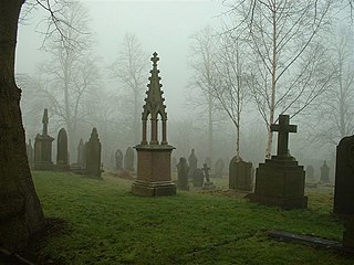
Holy Trinity Church, Holmfirth is an Anglican church in the town of Holmfirth in West Yorkshire, England.

References

  1. "Population statistics Hepworth Tn/CP through time". A Vision of Britain through Time . Retrieved 11 August 2023.
  2. Mills, A.D. (1991). A Dictionary of British Place-Names. Oxford University Press. ISBN   0-19-852758-6.
  3. Langdale, Thomas (1822). A Topographical Dictionary of Yorkshire. Northallerton and Ripon: J. Langdale & T. Langdale.
  4. "History of Hepworth, in Barnsley and West Riding". A Vision of Britain through Time. Retrieved 11 August 2023.
  5. "Relationships and changes Hepworth Tn/CP through time". A Vision of Britain through Time. Retrieved 11 August 2023.