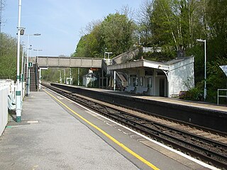
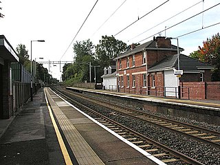
Balcombe railway station is on the Brighton Main Line in England, serving the village of Balcombe, West Sussex. It is 33 miles 64 chains (54.4 km) down the line from London Bridge via Redhill and is situated between Three Bridges and Haywards Heath. It is managed by Southern.
Allerton railway station was a railway station on the City Line of the Merseyrail network, located in the suburbs of Liverpool, England.

Aigburth railway station serves the Aigburth district of Liverpool, England. It is situated on the Southport–Hunts Cross route of the Northern Line of the Merseyrail suburban system.
Adlington (Cheshire) railway station serves the village of Adlington in Cheshire, England.

Alderley Edge railway station serves the large village of Alderley Edge in Cheshire, England. The station is 13¾ miles (22 km) south of Manchester Piccadilly on the Crewe to Manchester Line.

Audley End railway station is on the West Anglia Main Line serving the village of Wendens Ambo and the town of Saffron Walden in Essex, England. It is 41 miles 55 chains (67.1 km) down the line from London Liverpool Street and is situated between Newport and Great Chesterford stations. Its three-letter station code is AUD.
Warbreck railway station was on the North Liverpool Extension Line to the south of Walton Vale, Liverpool, England.

Bagshot railway station serves the village of Bagshot, in the west of Surrey, England. The station, and all trains calling there, are operated by South Western Railway. It is situated on the Ascot to Guildford line, 32 miles 8 chains (51.7 km) from London Waterloo.

Dingle railway station is a disused underground railway station located on the Liverpool Overhead Railway (LOR), at the south end of Park Road, Dingle, Liverpool. It was the only below ground station on the line. Trains accessed the station via a half-mile tunnel, bored from the cliff face at Herculaneum Dock to Park Road. It is the last remaining part of the Overhead railway, with the surface entrance still standing. The former platform and track area were in use as a garage called Roscoe Engineering until 2015.
Mauchline railway station was a railway station serving the town of Mauchline, East Ayrshire, Scotland. The station was originally part of the Glasgow, Paisley, Kilmarnock and Ayr Railway.

Altcar Rifle Range railway station was a railway station on the Liverpool, Crosby and Southport Railway, situated a third of a mile north of Hightown, Merseyside.
Ainsworth Road Halt railway station was a railway station serving the northern part of Radcliffe, Greater Manchester, England.

Wolvercote Halt was a railway station at Upper Wolvercote near Oxford on the Varsity Line. The London and North Western Railway opened the halt in 1905 and the London, Midland and Scottish Railway closed it in 1926. It was situated on the southern side of First Turn.
Annfield Plain railway station was in County Durham in Northern England, on the original south section of the industrial Stanhope and Tyne Railway, which diverged from the East Coast Main Line south of Newcastle.
The first station in the area opened in 1860 as Dudley and served Dudley Colliery and the village of Dudley in North Tyneside, England. It was located on the East Coast Main Line to the north of Newcastle upon Tyne. In 1874 it was renamed Dudley Colliery before becoming Annitsford in April 1878. On 8 July 1878 the station was closed and replaced with a second station 352 yards south of the first station. The railway station was located in Dudley but was named after the nearby village of Annitsford, to avoid confusion with another Dudley in the Midlands.
Toxteth Dock railway station was on the Liverpool Overhead Railway, adjacent to the dock of the same name and the Brunswick Goods station on the Cheshire Lines railway, England. It was situated above a London Midland & Scottish goods railway station.

Aycliffe railway station served the village of Aycliffe in County Durham, England. The railway station was served by trains on the main line between Darlington and Durham.

Newcastle railway station was on the Belfast and County Down Railway which ran from Belfast to Newcastle, County Down in Northern Ireland.
Londonderry Graving Dock railway station served Derry in County Londonderry in Northern Ireland.
Ramsden Dock railway station was the terminus of the Furness Railway's Ramsden Dock Branch in Barrow-in-Furness, England.