Heringen

Last updated
Heringen
Wappen HeringenWerra.jpg
Location of Heringen within Hersfeld-Rotenburg district
Heringen (Werra) in HEF.svgNentershausenPhilippsthalFriedewaldNeuensteinKirchheim
Germany adm location map.svg
Red pog.svg
Heringen
Hesse location map.svg
Red pog.svg
Heringen
Coordinates: 50°53′14″N10°00′20″E / 50.88722°N 10.00556°E / 50.88722; 10.00556 Coordinates: 50°53′14″N10°00′20″E / 50.88722°N 10.00556°E / 50.88722; 10.00556
Country Germany
State Hesse
Admin. region Kassel
District Hersfeld-Rotenburg
Subdivisions8 districts
Government
   Mayor (202228) Daniel Iliev [1] (SPD)
Area
  Total61.18 km2 (23.62 sq mi)
Elevation
221 m (725 ft)
Population
 (2020-12-31) [2]
  Total7,146
  Density120/km2 (300/sq mi)
Time zone UTC+01:00 (CET)
  Summer (DST) UTC+02:00 (CEST)
Postal codes
36266
Dialling codes 06624
Vehicle registration HEF
Website www.heringen.de

Heringen (Werra) is a small town in Hersfeld-Rotenburg district in eastern Hesse, Germany lying right at the boundary with Thuringia.

Contents

Geography

Heringen with K+S Kali GmbH's Wintershall works in the middle. Taken from Monte Kali Wintershall Heringen 02.jpg
Heringen with K+S Kali GmbH's Wintershall works in the middle. Taken from Monte Kali
Former East German border post on the Hesse-Thuringia boundary between Kleinensee and Grossensee DDR Grenzpfahl 02.jpg
Former East German border post on the Hesse-Thuringia boundary between Kleinensee and Großensee

Location

The nearest major towns and cities are Bad Hersfeld (28 km to the west), Eisenach (30 km to the northeast) and Kassel (80 km to the north). The town lies on the river Werra, surrounded by outliers of the Thuringian Forest, the Seulingswald and the Anterior Rhön, all mountain or hill ranges.

The lowest point in town is found on the Werra floodplain at 210 m above sea level. The highest point within town limits is the Lehnberg at 471 m above sea level.

Neighbouring communities

Clockwise from the north, these are Wildeck, Verwaltungsgemeinschaft Berka/Werra, Philippsthal (Werra) und Friedewald.

Constituent communities

Heringen's Stadtteile , besides the main centre, also called Heringen, are Bengendorf, Herfa, Kleinensee, Leimbach, Lengers, Widdershausen and Wölfershausen.

History

The Salzberg ("Salt Mountain", also known locally as "Monte Kali") at the Wintershall potash works in Heringen Salzberg kaliwerk wintershall heringen.jpg
The Salzberg (“Salt Mountain”, also known locally as “Monte Kali”) at the Wintershall potash works in Heringen
The outlying centre of Kleinensee with "Monte Kali" in the background Heringen Kleinensee 01.jpg
The outlying centre of Kleinensee with “Monte Kali” in the background

In 1153, Heringen had its first documentary mention. The Fulda Abbey enfeoffed the nobleman Heinrich von Heringen about 1170 with the place. The Heringen court comprised in the early 15th century not only the current town area but also the Thuringian centres of Vitzeroda, Gasteroda and Abteroda, all of which now belong to the Verwaltungsgemeinschaft Berka/Werra. In 1432, Margarethe von Heringen sold the court to the Landgraves of Hesse, thereby binding Heringen to Hesse.

With the opening of the Wintershall potash works, which began mining in 1903, the community got its first industrial jobs. Later, the Neu-Heringen and Herfa-Neurode potash mines were built. The mine is today the world's biggest potash-mining area and has an area about the same as Greater Munich's.

At the end of World War II, the libraries of the German Army's Military Geology Unit (Wehrgeologenstellen) and the German Patent Office (Reichspatentamt) were removed from Berlin and secretly stored in the deep Wintershall potash mine in Heringen. There they were discovered by the US Third Army in March 1945, and removed to the US. The German Patent Library was later restored to Germany, but the military geology materials of maps, reports and books, often stolen from other countries during the invasions, were retained by the US as Nazi materiel. [3] Most of these maps and books remain in the US Geological Survey Library today, with an obscure United States Army Corps of Engineers stamp on each that reads "Heringen Collection". [4]

Market rights were granted the community in 1526, and in 1977 came town rights to what was then a greater community (formed out of several smaller former communities).

There are also successor buildings of the knightly estate of Vultejus.

Amalgamations

Between 1968 and 1972 the above-named centres were amalgamated into a greater community, which was granted town rights in 1977 by the Hesse Land government.

Population development

Constituent communitiesPopulation
 199819992000200120022003
Heringen3,4023,5583,6373,6313,6033,623
Bengendorf696868687072
Herfa836880869867853838
Leimbach471488511512522504
Lengers1,0191,0921,0721,0721,0711061
Kleinensee655726722722726724
Widdershausen1,1401,2041,1901,1901,2031,193
Wölfershausen1,0911,1501,1391,1371,1171,101
Totals8,6839,1669,2089,1999,1659,116

Politics

Town council

The municipal election held on 26 March 2006 yielded the following results:

Parties and voter communities%
2006
Seats
2006
%
2001
Seats
2001
CDU Christian Democratic Union of Germany 24.8826.58
SPD Social Democratic Party of Germany 40.01250.116
WGHWählergruppe Gemeinschaftsliste Heringen35.21122.37
FDP Free Democratic Party 1.00
Total100.031100.031
Voter turnout in %59.364.5

The town's executive (Magistrat) is made up of six councillors, with two seats allotted to the SPD, two to the CDU and 2 to the WGH. Manfred Wenk is the first ever WGH councillor.

Mayor

Mayor Daniel Iliev was elected on 20 March 2016.

Heringen's old coat of arms, borne until 2003 Wappen Heringen (Werra).png
Heringen's old coat of arms, borne until 2003

Coat of arms

The town's arms might be described thus: Azure a bend wavy sinister argent between a sledgehammer and a cross-peen hammer per saltire, and three fish of the last.

The bend wavy sinister, that is, slanted wavy stripe beginning on the sinister (armsbearer's left, viewer's right) side and stretching down across the escutcheon, stands for the river Werra. The three fish come from the arms formerly borne by the Lords of Heringen (Hering is German for “herring”). The mining tools are, of course, a traditional miner's symbol. This charge was added to the coat of arms in 2003, [5] as potash had been being mined here for a hundred years. The old arms are shown at right.

Town partnerships

In 2007, partnership documents were signed with the following towns:

Culture and sightseeing

Bodesruh border memorial Mahnmal bodelsruh heringen.jpg
Bodesruh border memorial

Museums

Buildings

Parks

Regular events

Economy and infrastructure

Research and development

It was in Heringen that the groundbreaking invention of the electrostatic salt separation facility (elektrostatische Salz-Trennungsanlage, or ESTA) was first realized and further developed. After former mining director Prof. Dr.-Ing. Arno Singewald's research and inventions, the German potash-mining industry could introduce a thoroughly novel, environmentally friendly means of processing the mined salts. Salt-saturated water is avoided when the ESTA is used. These facilities built at the potash works along the Werra have also seen to it that a river that was once thoroughly salted – by East German potash works – has been brought back to life.

Established businesses

Notable people

Related Research Articles

<span class="mw-page-title-main">Potash</span> Salt mixture

Potash includes various mined and manufactured salts that contain potassium in water-soluble form. The name derives from pot ash, plant ashes or wood ash soaked in water in a pot, the primary means of manufacturing potash before the Industrial Era. The word potassium is derived from potash.

Schwalm-Eder-Kreis is a Kreis (district) in the north of Hesse, Germany. Neighbouring districts are Kassel, Werra-Meißner, Hersfeld-Rotenburg, Vogelsberg, Marburg-Biedenkopf, and Waldeck-Frankenberg.

<span class="mw-page-title-main">Eschwege</span> Town in Hesse, Germany

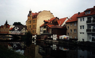
Eschwege, the district seat of the Werra-Meißner-Kreis, is a town in northeastern Hesse, Germany. In 1971, the town hosted the eleventh Hessentag state festival.

The Military Geology Unit was a unit in the United States military during World War II. It was established on June 24, 1942, six months after Pearl Harbor. People in the US Geological Survey wanted to get involved in the war effort, either for patriotism or prestige or both, and provided a geological intelligence report for a randomly chosen country, Sierra Leone.

<span class="mw-page-title-main">Spoil tip</span> Pile built of accumulated spoil

A spoil tip is a pile built of accumulated spoil – waste material removed during mining. These waste materials are typically composed of shale, as well as smaller quantities of Carboniferous sandstone and other residues. Spoil tips are not formed of slag, but in some areas, such as England and Wales, they are referred to as slag heaps. In Scotland the word bing is used.

<span class="mw-page-title-main">Waldkappel</span> Town in Hesse, Germany

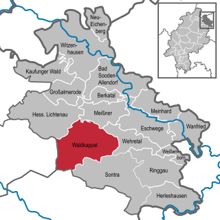
Waldkappel is a small town in the Werra-Meißner-Kreis district in northern Hesse, Germany.

<span class="mw-page-title-main">Philippsthal (Werra)</span> Municipality in Hesse, Germany

Philippsthal (Werra) is a market community in Hersfeld-Rotenburg district in eastern Hesse, Germany, right at the boundary with Thuringia.

<span class="mw-page-title-main">Wintershall</span> German oil and gas producer, 1894–2019

Wintershall Holding GmbH, based in Kassel, was Germany's largest crude oil and natural gas producer. It was a wholly owned subsidiary of BASF. The company was active in oil and gas exploration and production with operations in Europe, North Africa, South America as well as Russia and the Middle East region. Wintershall employed more than 2,000 people worldwide. In the 2018 financial year the company produced around 171 million barrels of oil equivalent (boe) of oil and gas. Revenues amounted to 4.09 billion euros.

<span class="mw-page-title-main">Meißner, Hesse</span> Municipality in Hesse, Germany

Meißner is a municipality in the Werra-Meißner-Kreis in Hesse, Germany.

<span class="mw-page-title-main">Ringgau</span> Municipality in Hesse, Germany

Ringgau is a municipality in the Werra-Meißner-Kreis in Hesse, Germany.

<span class="mw-page-title-main">Wildeck</span> Municipality in Hesse, Germany

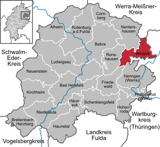
Wildeck is a municipality in Hersfeld-Rotenburg district in northeastern Hesse, Germany lying right at the boundary with Thuringia, 54 km southeast of Kassel.

<span class="mw-page-title-main">Nentershausen, Hesse</span> Municipality in Hesse, Germany

Nentershausen is a community in Hersfeld-Rotenburg district in northeastern Hesse, Germany.

Mining in the United States has been active since the beginning of colonial times, but became a major industry in the 19th century with a number of new mineral discoveries causing a series of mining rushes. In 2015, the value of coal, metals, and industrial minerals mined in the United States was US $109.6 billion. 158,000 workers were directly employed by the mining industry.

<span class="mw-page-title-main">Monte Kali</span> Mountain in Germany

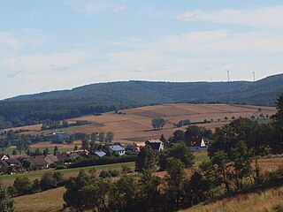
Monte Kali and Kalimanjaro are local colloquial names for the spoil heap or spoil tip that towers over the town of Heringen, Hesse, Germany. It is one of a number of sites where the K+S chemical company dumps sodium chloride, a byproduct of potash mining and processing, a major industry in the area.

<span class="mw-page-title-main">United States Geological Survey Library</span>

The United States Geological Survey Library is a program within the United States Geological Survey, a scientific bureau within the Department of Interior of the United States government. The USGS operates as a fact-finding research organization with no regulatory responsibility.

<span class="mw-page-title-main">Michael Roth (politician)</span> German politician (born 1970)

Michael Helmut Roth is a German politician of the Social Democratic Party of Germany (SPD) who has been serving as a member of the German Bundestag since 27 September 1998.

<span class="mw-page-title-main">Bad Salzungen station</span>

Bad Salzungen station is the railway station of the town of Bad Salzungen in the German state of Thuringia. It is located on the Werra Railway and on the Werra Valley Railway.

<span class="mw-page-title-main">Salzungen Werra Upland</span>

The Salzungen Werra Upland is a natural region in Germany that forms part of the East Hesse Highlands in the German states of Hesse and Thuringia.

<span class="mw-page-title-main">Seulingswald</span>

The Seulingswald is a hill range in the German Central Uplands which reaches heights of up to 480.3 m above sea level (NHN). It is part of the Fulda-Werra Uplands in the East Hesse Highlands within the Hessian county of Hersfeld-Rotenburg; small ridges extend into the Thuringian county of Wartburgkreis. It is a sandstone range and one of the largest contiguous woodland areas in Hesse.

<span class="mw-page-title-main">American occupation zone in Germany</span>

The American occupation zone was one of the four occupation zones established by the Allies of World War II in Germany west of the Oder–Neisse line in July 1945, around two months after the German surrender and the end of World War II in Europe. It was controlled by the Office of Military Government, United States (OMGUS) and ceased to exist after the establishment of the Federal Republic of Germany on 21 September 1949.

References

  1. "Ergebnisse der letzten Direktwahl aller hessischen Landkreise und Gemeinden" (XLS) (in German). Hessisches Statistisches Landesamt. 5 September 2022.
  2. "Bevölkerung in Hessen am 31.12.2020 nach Gemeinden". Hessisches Statistisches Landesamt (in German). June 2021.
  3. Willig, Dierk. 2009. Die Odyssee des Wehrgeologenarchivs als Teil der Heringen Collection: Versuch einer Rekonstruktion der Vorgänge von März 1945 bis heute. Euskirchen: Amt für Geoinformationswesen der Bundeswehr. 31 pages.
  4. Hadden, Robert Lee. 2008. "The Heringen Collection of the US Geological Survey Library of Reston, Virginia." Earth Sciences History, Volume 27, Number 2. Pages 242-265. ISSN   0736-623X.
  5. altes Wappen von Heringen altes Wappen der Stadt, vor 2003

Bibliography