Rotenburg an der Fulda (officially Rotenburg a.d. Fulda) is a town in Hersfeld-Rotenburg district in northeastern Hesse, in central Germany, situated, as the name says, on the river Fulda.
Historic row of houses in Rotenburg (an der Fulda)
Location
The town lies south of the Stölzinger Gebirge (range) in the narrowest part of the Fulda valley. The town's lowest point lies at 180m above sea level in the area near the two bridges across the Fulda linking Rotenburg's Old Town and New Town; these are the Alte Fuldabrücke (“Old Fulda Bridge”) and the Brücke der Städtepartnerschaften (“Bridge of Town Partnerships”). The town's highest point is the 548.7m-high Alheimer, lying on the town limit between Rotenburg and the neighbouring community of Alheim.
The nearest major towns are Bebra (some 6km to the southeast) and Bad Hersfeld (some 16km to the south), The nearest cities are Kassel (some 50km to the north) and Fulda (some 70km to the south).
Neighbouring communities
Clockwise from the north, these are Alheim, Spangenberg, Cornberg, Bebra and Ludwigsau. On the so-called Stölzinger Höhe (heights) in the northeast, above the outlying centre of Dankerode, Rotenburg has a boundary with the town of Waldkappel.
Constituent communities
Besides the main town, Rotenburg a.d. Fulda is made up of the outlying Stadtteile of Lispenhausen, Braach, Schwarzenhasel, Erkshausen, Seifertshausen, Dankerode, Atzelrode (with Alte Teich Estate and Wüstefeld) and Mündershausen.
History
Landgrave's palace in Rotenburg, front view of main building
In 769, the outlying centres of Braach and Lispenhausen, along with the now vanished village of Breitingen (which lay somewhere near the Hochmahle) had their first documentary mentions in the Hersfeld Abbey’s directory of holdings. These consisted of six estates and 90 Morgen of land.
The Gisonen were the Abbey’s Vögte (singular: Vogt). They built the first security castle in the Fulda valley once they had come to hold the Vogtei (the right to be Vogt). Around this castle arose a settlement. The Landgraves of Thuringia, who inherited the Vogtei from the Gisonen, built on the Alter Turm (mountain) Rodenberg Castle, which today lies in ruins, but is believed to be the town’s namesake.
The settlement on the Fulda’s left bank, today’s Altstadt (“Old Town”), had its first documentary mention as a town in 1248, and after the Thuringian-Hessian War of Succession in 1264 the town belonged to the Landgraviate of Hesse. The old castle in the valley had supposedly been removed sometime after 1423. In 1470 arose the first Schloss Rotenburg. A great town fire destroyed the Old Town in 1478 along with the newly built Schloss. Between 1627 and 1834, Rotenburg was a residence town of the landgrave family of Hesse-Rotenburg, the so-called Rotenburger Quart.
Rotenburg in an engraving by Matthäus Merian from 1655
In 1615, 57 houses burnt down in Braach, and in the Thirty Years' War, in 1637, the town and the town hall burnt. The fire was set by soldiers from the Isolani Regiment. In March 1882, the volunteer fire brigade was started as a club. In 1900 it acquired an equipment shed with a drying tower near the Fulda.
Following the joint German-Soviet invasion of Poland, which started World War II in 1939, it was the location of the Oflag IX-C prisoner-of-war camp for Polish officers and orderlies, which in June 1940 was converted into a subcamp of the Oflag IX-A camp in Spangenberg, and then held Belgian officers.[3] Rotenburg has belonged since 1972 to Hersfeld-Rotenburg district, before which it was the old Rotenburg district's seat. In 2003, the town earned unwanted fame through Armin Meiwes.
In 2004, the town earned a silver medal in the national contest Unsere Stadt blüht auf (“Our Town is Blossoming”), and in 2005 it earned a gold medal with a special prize for the landscaping design of the Fulda floodplain.
In August 2007, the volunteer fire brigade staged the 20th Hessian Fire Brigade Day with an extensive programme of events on the occasion of its 125 anniversary of founding.
The town's executive (Magistrat) is made up of six councillors, including the mayor, with four seats allotted to the SPD and two to the CDU.
Mayor
The mayor is Christian Grunwald, elected in 2011 and re-elected in 2017.
Coat of arms
Town's coat of arms on the Town Hall steps in Rotenburg
The town's arms might be described thus: Argent at the nombril point a mount of three gules surmounted by a bough vert in fess arising from the bottom of which and growing in pale a sprig of three linden leaves vert.
The German blazon describes the “mount” as a Dreiberg, even though in the artistic rendering seen here, it does not have the same shape that this charge usually has in German civic coats of arms. See, for instance, Nentershausen's, Neuenstein's or Philippsthal's coat of arms.
The arms come from the early 17th century. The mound stands for the Rotenberg, a mountain on which once stood a castle. From these, the town got its name. The linden sprig comes from old guild seals, which bore a cloverleaf and a star. From this arose the linden sprig, which was adopted as a charge in the town's arms, putting the coat of arms in the “North Hesse Cloverleaf Arms Family” along with Kassel and Felsberg. The first example of the arms now valid in the town was in the Knights’ Hall (Rittersaal), which was torn down in the late 18th century.[4] The first examples on mediaeval town seals show a saint bearing a palm frond before a town gate. It most likely was meant to be the town's patron saint, James the Elder.
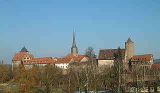
The most important sights in the town are these following:
Schloss Rotenburg, built in Renaissance style between 1570 and 1607, remodelled about 1790, today houses the Hesse State Financial School, includes preserved side building and palace park.
Town Hall, built in 1597–1598 and remodelled in the Baroque period; on 23 September 1637 the town was burnt down by Colonel Isolani's people. The statue of Saint James at the Town Hall “fell crashing onto the marketplace and burst asunder” (according to the chronicler).
Saint James's Parish Church
Saint Elizabeth and Mary Monastery Church in the New Town, built beginning in 1370, crypt of the Landgraves of Hesse. Only Landgrave Moritz the Learned's son, Hermann, the first Quartfürst of Hesse-Rotenburg is buried here next to his consort Kunigunde Juliane of Anhalt-Zerbst. From this princely house also sprang Russian Tsaritsa Catherine the Great.
On the Alter Turm (mountain, 418.1m above sea level) are hidden the ruins of Rodenberg Castle (from about 1150).
On the Fulda is found an old lock from the 17th century.
The mikvah, the former Jewish community's ritual bath, since 2006 a memorial and meeting place and Jewish Museum. There are two websites with extensive information, www.mikwe.de and www.hassia-Judaica.de.
Rotenburg further has other historic churches and interesting houses. Even parts of the mediaeval town wall from the 12th and 13th centuries with two round towers are preserved.
Historic row of houses in Rotenburg an der Fulda
St. Elisabeth und Marien Monastery Church
Jakobikirche (St. James's)
Stable
Lock from the 17th century
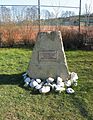
Memorial stone to the community of Breitingen
Regular events
Heimat- und Strandfest (“Homeland and Beach Festival”, every year on the first weekend in July)
Historic Christmas Market on Rotenburg's Marketplace and in adjoining lanes (from early December – 16 days) with Germany's tallest Christmas pyramid
Kuckucksmarkt (“Cuckoo’s Market”) in the outlying centre of Braach (North Hesse art, craft and farmers’ market held on the last weekend of each month from May to October)
Economy and infrastructure
Rotenburg Cardiovascular Centre
Especially important to the town and the whole area is the Herz-Kreislauf-Zentrum (HKZ – Cardiovascular Centre) on the south slope above the town.
As at January 2006, 4,188 workers are employed in town, of which 989 jobs are offered by producing businesses, 2,143 by service providers, 367 by trade, 80 by forestry and agriculture and 609 by other fields of endeavour. There are 1,325 beds dedicated to tourism.
Established businesses
RMW Rotenburger Metallwerke GmbH
C. Brühl Komplementär Textilwerk Rotenburg Verwaltungsgesellschaft mbH (textile specialist in trousers, shirts and jackets)
Hessische/Niedersächsische Allgemeine (daily newspaper) with its Lokalteil Rotenburg Bebra (local section) and the Kreisanzeiger published district-wide.
State institutions
Until it was disbanded early in 2006, the Panzergrenadierbataillon 52 (Armoured Grenadier Battalion 52) was stationed at the Alheimer-Kaserne (“Alheim Barracks”). Since July 2006, the newly deployed Führungsunterstützungsbataillon 286 (“Command Support Battalion 286”) have been there. Joining them is the 6th Company of the Feldjägerbataillon 251 (“Military Police Battalion 251”), which was formerly stationed in Schwalmstadt. The FüUstgBtl 286 belongs to the Command Support Regiment 28 in Mechernich and is part of the Bundeswehr’s Streitkräftebasis (SKB).
Rotenburg Study Centre: Hesse State Financial School, Professional Administration College of the State of Hesse.
Training and Continuing Education Centre of HSVV “Marstall”
BKK-Akademie – conference and seminar hotel
Education
Jakob-Grimm-Schule in Rotenburg
There are ten schools in town, among them the Jakob-Grimm-Schule, which acts as an ancillary comprehensive school with a Gymnasium upper level. There is also the BKK Akademie, where there is training in social insurance law and related themes for those employed in the field.
Gustav Adolf Hohenlohe (born 26 February 1823 in Rotenburg; died 30 October 1896 in Rome); German Cardinal.
Franz Vetter (born 1824 in Rotenburg, died 27 February 1896 in Potsdam); Electoral court gardener, from 1891 royal Prussian chief court gardener at Sanssouci.
Elise zu Salm-Horstmar (born 6 January 1831 in Rotenburg, died 29 June 1920); writer.
Jakob Wilhelm Georg Vilmar (born 4 June 1804 in Solz, died 7 December 1884 in Melsungen), clergyman of the Hessische Renitenz, clergyman in Rotenburg (1830–1851).
Walter Wallmann (born 24 September 1932 in Uelzen), Chief Mayor of Frankfurt am Main, Federal Minister for Environment, Conservation and Reactor Safety (1986–1987), Hessian premier (1987–1991), judge at the Amt court in Rotenburg (1966).
Grave of WWII British military persons imprisoned at Rotenburg.
Further reading
Albert Deist, Thomas Sippel: Rotenburg an der Fulda. Sutton Verlag 2005, ISBN3-89702-852-2
Heinrich Nuhn: Ein Rundgang durch Rotenburg a.d. Fulda. Spuren jüdischen Lebens. 2001, ISBN3-933231-18-3
Angela Pooch: Historische Einblicke in unsere Stadt. Archiv der Stadtverwaltung, 1997, ISBN3-932580-02-8
Albert Deist, Thomas Sippel Rotenburg an der Fulda: 1948 bis 1983 2008 Sutton Verlag ISBN3-86680-251-X
Heinrich Nuhn, Die Rotenburger Mikwe. Kultudenmal und Zeugnis der Vielfalt jüdischen Lebens, 2006, ISBN3-933734-11-8 Mitka's Secret by Steven Brallier - true story of Mitka Kalinski, slave to Nazi SS officer Gustav Dohr of Badagasse 14
Related Research Articles
The Fulda is a river of Hesse and Lower Saxony, Germany. It is one of two headstreams of the Weser. The Fulda is 220.4 kilometres (137.0 mi) long.
Bebra is a small town in Hersfeld-Rotenburg district in northeastern Hesse, Germany.
Melsungen is a small climatic spa town in the Schwalm-Eder district in northern Hesse, Germany. In 1987, the town hosted the 27th Hessentag state festival.
Oberaula is a municipality in the Schwalm-Eder district in Hesse, Germany.
Spangenberg is a small town in northeastern Hesse, Germany.
Romrod is a small town in the Vogelsbergkreis in central Hesse, Germany.
Schlitz is a small town in the Vogelsbergkreis in eastern Hesse, Germany.
Sontra is a small town in the Werra-Meißner-Kreis in northeastern Hesse, Germany.
Philippsthal (Werra) is a market community in Hersfeld-Rotenburg district in eastern Hesse, Germany, right at the boundary with Thuringia.
Alheim is a municipality in Hersfeld-Rotenburg district in northeastern Hesse, Germany. It is named after nearby Alheimer Mountain. Alheim consist of 10 former souverain villages situated on both banks of the river Fulda.
Wildeck is a municipality in Hersfeld-Rotenburg district in northeastern Hesse, Germany lying right at the boundary with Thuringia, 54 km southeast of Kassel.
Neuenstein is a municipality in the Hersfeld-Rotenburg district of northeastern Hesse, Germany.
Hauneck is a municipality in Hersfeld-Rotenburg district in eastern Hesse, Germany.
Hohenroda is a municipality in Hersfeld-Rotenburg district in eastern Hesse, Germany lying right on the boundary with Thuringia.
Cornberg is a municipality in Hersfeld-Rotenburg district in northeastern Hesse, Germany. It is the district's smallest municipality.
Friedewald is a municipality in Hersfeld-Rotenburg district in eastern Hesse, Germany, directly east of Bad Hersfeld.
Ludwigsau is a municipality in Hersfeld-Rotenburg district in northeastern Hesse, Germany. With an area of 112 km² it is Hesse's biggest community by land area.
Ronshausen is a municipality and a Luftkurort in Hersfeld-Rotenburg district in northeastern Hesse, Germany.
Countess Juliane of Nassau-Siegen, German: Juliana Gräfin von Nassau-Siegen, official titles: Gräfin zu Nassau, Katzenelnbogen, Vianden und Diez, Frau zu Beilstein, was a countess from the House of Nassau-Siegen, a cadet branch of the Ottonian Line of the House of Nassau, and through marriage landgravine of Hesse-Kassel.
The Fulda-Werra Uplands are a major natural regional unit in the East Hesse Highlands in East and North Hesse and, with small elements in the southeast, in the German state of Thuringia. Most of the range lies right of the River Fulda and left of the Werra. The uplands extend from the Rhön mountains northwards, to the River Weser near Hann. Münden.
↑ Megargee, Geoffrey P.; Overmans, Rüdiger; Vogt, Wolfgang (2022). The United States Holocaust Memorial Museum Encyclopedia of Camps and Ghettos 1933–1945. Volume IV. Indiana University Press, United States Holocaust Memorial Museum. pp.259–261. ISBN978-0-253-06089-1.
↑ Wilhelm Wessel 1623: „Folgen die Wapen aller Städte in Fürstenthümern und Graffschaften dero Fürsten zu Hessen wie sie in Rotenbergk im Fürstlichen Schloß/ im großen Saal zu finden.“
This page is based on this Wikipedia article Text is available under the CC BY-SA 4.0 license; additional terms may apply. Images, videos and audio are available under their respective licenses.