Heyburn State Park

Last updated

Heyburn State Park
IUCN category V (protected landscape/seascape)
Heyburn State Park, Idaho.jpg
Heyburn State Park
USA Idaho relief location map.svg
Red pog.svg
Location in Idaho
Usa edcp relief location map.png
Red pog.svg
Location in the United States
Location Benewah County and Kootenai County, Idaho, United States
Nearest city Plummer, Idaho
Coordinates 47°21′12″N116°45′41″W / 47.3532382°N 116.7612847°W / 47.3532382; -116.7612847 [1]
Area8,076 acres (32.68 km2) [2]
Elevation2,385 ft (727 m) [1]
Max. elevation3,366 ft (1,026 m)
Min. elevation2,128 ft (649 m)
Designation Idaho state park
Established1908 [3]
Named for Weldon B. Heyburn
Administrator Idaho Department of Parks and Recreation
Website Heyburn State Park

Heyburn State Park is a public recreation area in the U.S. state of Idaho. It is located almost entirely in Benewah County, with a small portion extending into southern Kootenai County. The park was founded in 1908 and is the oldest state or provincial park in the Pacific Northwest. [3] [4] The park has 5,744 acres (23.2 km2) of land and 2,332 acres (9.4 km2) of water on three lakes: Benewah, Chatcolet, and Hidden. A dam constructed on the Spokane River in Post Falls in 1906 raised the level of Lake Coeur d'Alene, connecting it to the park's three lakes. [5] The surface elevation of the lakes is 2,125 feet (648 m) above sea level. [6] The park's year-round recreational opportunities include camping, boating, hiking, horseback riding, fishing, and picnicking. [2]

Contents

History

The Coeur d'Alene were the first inhabitants in what is now Heyburn State Park. Originally members called themselves, "Schitsu'umsh," meaning "The Discovered People" or "Those Who Are Found Here." [7] The Natives found an abundance of fish in the three lakes of the park as well as in the Saint Joe River. Waterfowl inhabited the wetlands and deer, bear and various birds were plentiful in the grassy meadows and slopes of the surrounding mountains. [2] Prior to the arrival of European American settlers, the Coeur d'Alene lived in what would become the Idaho Panhandle. The first Europeans to encounter the Coeur d'Alene were French traders and trappers. [8] They found the tribe to be experienced and skilled at trading, thus the name "Coeur d'Alene," meaning "heart of the awl." One French trader described the tribe as "the greatest traders in the world." [8] The tribe ranged over an area of over 4 million acres (16,000 km2) of grassy hills, camas-prairie, wooded mountains, lakes, marshes and river habitat in northern Idaho, eastern Washington and western Montana. [8]

The Coeur d'Alene lands were reduced to approximately 600,000 acres (940 sq mi; 2,430 km2) in 1873 when President Ulysses Grant established the Coeur d'Alene Indian Reservation. Successive government acts trimmed their property to 345,000 acres (540 sq mi; 1,400 km2) [7] Heyburn State Park was formed from 5,500 acres (22 km2) of land and 2,333 acres (9.44 km2) of water that were taken from the Coeur d'Alene on April 20, 1908 when President William H. Taft deeded the land to the state for the creation of Heyburn State Park named for U.S. Senator Weldon Heyburn of Idaho. [2] Heyburn had envisioned Chatcolet National Park, which passed the Senate but stalled in the House. [5]

Construction of many of the park's facilities was performed during the Great Depression by the Civilian Conservation Corps. [9] [10] [11] Members at Camp SP-1 built a lodge, roads, bridges, trails, picnic areas and shelters and campgrounds; many are still in use. [2]

Ecology

Heyburn State Park is home to a variety of habitats. Ponderosa pines, some over 400 years old, are on the mountain sides overlooking grassy hills that are covered with wildflowers. Other trees in the park included cedar, hemlock and white pine. The margins of the lake are marshy homes to wildflowers and plants. [2]

Activities and amenities

The 72-mile (116 km) Trail of the Coeur d'Alenes bike trail passes through the park, crossing the Saint Joe River on a 3,100-foot (940 m) trestle. The river and Hidden Bay, Chatcolet Lake, and Benewah Lake, all sections of the larger Lake Coeur d'Alene, are used for boating, water sports, and fishing. Common game fish include bass, pike and pan fish. The park's marina offers a boat launch, fuel dock, and supplies. [2]

Plummer Creek Marsh

Plummer Marsh inside Heyburn State Park 02-06-18, swamp - panoramio.jpg
Plummer Marsh inside Heyburn State Park

The Plummer Marsh is a short walk along a boardwalk scattered with information kiosk, viewing blind, and benches. This boardwalk provides an opportunity to enjoy the luscious ecosystem the low-lying wet lands and grassy vegetation while taking pleasure in the scenery of the St. Joe Baldy, Reeds Baldy, and Huckleberry Mt.

Birding

Birding in Heyburn State Park Idaho Birding Trail Heyburn State Park.jpg
Birding in Heyburn State Park

A large variety of birds can be spotted in various locations inside the park, ranging from small to large species and depending upon the time of the year will provide a birding experience worth experiencing. It is common to observe a Great Blue Heron rookery consisting of 35-50 pairs of breeding herons in the park during the Spring months. The summer months will produce the experience of observing Osprey, Wood Ducks, Canada Geese, Red-necked Grebes and Soras. The most abundant species of fowl are the American Wigeon, Mallards, and Canada Geese, all of whom make Heyburn State Park their year round residence. It is said there are "several records of vagrant birds here including Eurasian Wigeon, Swamp Sparrow, White-throated Sparrow, Bewick’s Wren, Greater Scaup, and even a record of an Ancient Murrelet." [12]

Trails

Several different types of trails are offered for exploring depending on your preference. Bring your mountain bike to ride the trails in the forest, or an electric bike for enjoying a smooth ride on the paved Trail of the Coeur d' Alenes, There are also trails specific to horse riding and hiking.

All trails within Heyburn State Park include: [13]

Lakeshore Loop Trail near Plummer Marsh Heyburn State Park.jpg
Lakeshore Loop Trail near Plummer Marsh

Marina

Rocky Point Marina offers a ADA boat ramp for use.

Overnight Options

Heyburn offers various overnight recreation opportunities for those looking for tent camping, RV hook-up to water and electricity, in addition to dry cabins/cottages. Limited spaces for ADA. [12] Be prepared to pay a fee for day use areas, campsites, and/or have your Idaho State Parks Passport sticker displayed on your vehicle. Fees vary depending on state residency. [14]

ADA Accessibility

Hunting and Fishing

Idaho's first state park protects the animals that live within its boundary from hunting with the exception of the waterfowl. This is due to the abundance of waterfowl species who call the park home. In order to keep the numbers at a healthy balance with their habitat hunting is allowed according to the IDAPA 26.01.20.575, “Rule on Protection of Wildlife in State Parks,” in order to expand recreational opportunities in parks where it is appropriate, as well as assist wildlife managers in achieving population objectives. [15]

No Hunting EXCEPT Waterfowl No hunting Heyburn State Park.jpg
No Hunting EXCEPT Waterfowl

A 300-foot safety zone may be designated around trailheads and park facilities by the park manager during established hunting seasons. Shooting off the docks and beaches are not allowed. [12] Although Heyburn State Park is approved for hunting by the Board, hunting might only be allowed in limited circumstances by park rule, therefore it is important to check with the park headquarters prior to engaging in the activity. [15] Bird blinds can be used and need to be removed the same day.

Heyburn State Park offers anglers an opportunity to catch different species of fish, both offshore and from a boat. Each watercraft is subject to an inspection for invasive species. Idaho law requires that any motorized or non-motorized boat operating in Idaho requires an Invasive Species Sticker. [16]

See also

Related Research Articles

<span class="mw-page-title-main">Benewah County, Idaho</span> County in Idaho, United States

Benewah County is a county located in the northwest part of the U.S. state of Idaho. As of the 2020 United States Census the county had a population of 9,530. The county seat and largest city is St. Maries, which has some area inside the Coeur d'Alene Reservation.

<span class="mw-page-title-main">Coeur d'Alene, Idaho</span> City in Idaho, United States

Coeur d'Alene is a city and the county seat of Kootenai County, Idaho, United States. It is the largest city in North Idaho and the principal city of the Coeur d'Alene Metropolitan Statistical Area. At the 2020 census the city's population was 54,628. Coeur d'Alene is a satellite city of Spokane, which is located about thirty miles (50 km) to the west in the state of Washington. The two cities are the key components of the Spokane–Coeur d'Alene Combined Statistical Area, of which Coeur d'Alene is the third-largest city. The city is situated on the north shore of the 25-mile (40 km) long Lake Coeur d'Alene and to the west of the Coeur d'Alene Mountains. Locally, Coeur d'Alene is known as the "Lake City," or simply called by its initials, "CDA."

<span class="mw-page-title-main">Farragut State Park</span> State park in Idaho, United States

Farragut State Park is a public recreation area located at the southern tip of Lake Pend Oreille in the Coeur d'Alene Mountains of the Idaho Panhandle in the northwest United States. The 4,000-acre (1,600 ha) state park is five miles (8 km) east of Athol in Kootenai County, about thirty miles (50 km) northeast of Coeur d'Alene. Activities include camping, picnicking, hiking, mountain biking, cycling, fishing, boating, swimming, water sports, orienteering, disc golf, flying model aircraft, archery, and horseback riding.

<span class="mw-page-title-main">Coeur d'Alene people</span> Federally recognized Native American tribe in northern Idaho, United States

The Coeur d'Alene Tribe are a Native American tribe and one of five federally recognized tribes in the state of Idaho.

<span class="mw-page-title-main">Coeur d'Alene Reservation</span> Native American reservation in northern Idaho, United States

The Coeur d'Alene Reservation is a Native American reservation in northwestern Idaho, United States. It is home to the federally recognized Coeur d'Alene, one of the five federally recognized tribes in the state.

<span class="mw-page-title-main">Idaho Panhandle</span> Region of the U.S. state of Idaho

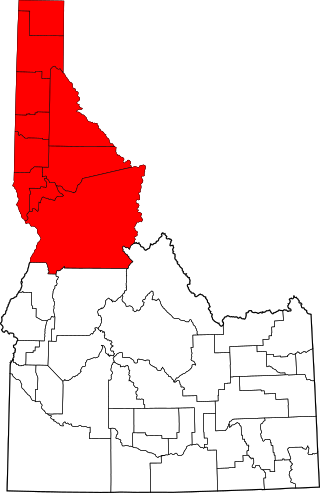
The Idaho Panhandle—locally known as North Idaho—is a salient region of the U.S. state of Idaho encompassing the state's 10 northernmost counties: Benewah, Bonner, Boundary, Clearwater, Idaho, Kootenai, Latah, Lewis, Nez Perce, and Shoshone. The Panhandle is bordered by the state of Washington to the west, Montana to the east, and the Canadian province of British Columbia to the north. The Idaho panhandle, along with Eastern Washington, makes up the region known as the Inland Northwest, headed by its largest city, Spokane, Washington.

<span class="mw-page-title-main">Lake Coeur d'Alene</span> Glacial lake in Idaho, US

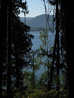
Lake Coeur d'Alene, officially Coeur d'Alene Lake, is a natural dam-controlled lake in North Idaho, located in the Pacific Northwest region of the United States. At its northern end is the city of Coeur d'Alene. It spans 25 miles (40 km) in length and ranges from 1 to 3 miles (5 km) wide with over 109 miles (175 km) of shoreline.

<span class="mw-page-title-main">Weldon B. Heyburn</span> American politician

Weldon Brinton Heyburn was an American attorney and politician who served as a United States Senator from Idaho from 1903 to 1912.

<span class="mw-page-title-main">Trail of the Coeur d'Alenes</span>

The Trail of the Coeur d'Alenes is a rail trail in the northwest United States, in northern Idaho. It follows the former Union Pacific Railroad right-of-way from Mullan, a mountain mining town near the Montana border, westward to Plummer, a town on the prairie near the Washington border. Generally following the Coeur d'Alene River, the rail line was abandoned in 1991, and the trail officially opened in March 2004.

<span class="mw-page-title-main">Interstate 90 in Idaho</span> Section of Interstate Highway in Idaho, United States

Interstate 90 (I-90) is a transcontinental Interstate Highway that runs east–west across the northern United States. Within the state of Idaho, the freeway travels for 74 miles (119 km) from the Washington border near Spokane to Coeur d'Alene and the panhandle region at the north end of the state. After traveling through the Silver Valley along the Coeur d'Alene River in the Bitterroot Range, I-90 crosses into Montana at Lookout Pass.

<span class="mw-page-title-main">Sports in Spokane, Washington</span>

Spokane, Washington has a rich sporting culture and the area residents are active in many spectator and participant sports. Although Spokane lacks any major, nationally recognized professional sports team, Spokane has a sports friendly atmosphere, and was recognized and rated #99 in the Sporting News 2006 "99 Best Sporting Cities" list. In 2009, Sports Business Journal rated Spokane as the fifth best minor league sports market in America out of 239 markets.

<span class="mw-page-title-main">Saint Joe River</span> Tributary of Coeur dAlene Lake in northern Idaho

The Saint Joe River is a 140-mile (225 km) long tributary of Coeur d'Alene Lake in northern Idaho. Beginning at an elevation of 6,487 feet (1,977 m) in the Northern Bitterroot Range of eastern Shoshone County, it flows generally west through the Saint Joe River Valley and the communities of Avery and Calder. Past Calder, it flows into Benewah County and through the town of St. Maries, where it receives its largest tributary, the Saint Maries River. It then turns northwest, passing through Heyburn State Park before reaching its mouth just north of the Kootenai County line. Much of the river's route through Heyburn State Park is partially flooded due to raised water levels from the Washington Water Power dam at Post Falls on the Spokane River below Coeur d'Alene Lake. With a mouth elevation of 2,129 feet (649 m), it is claimed to be the highest navigable river in the world. Multiple rivers in Canada are both higher and navigable, including the Babine, and Middle Rivers.

<span class="mw-page-title-main">Idaho State Highway 5</span> State highway in Idaho, United States

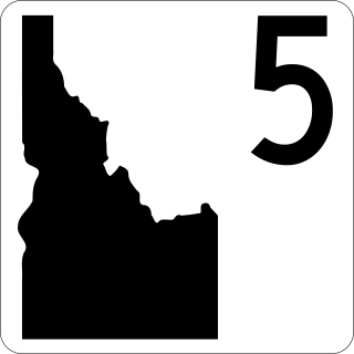
State Highway 5 (SH-5) is a state highway in Benewah County, in the U.S. state of Idaho. It runs 19.108 miles (30.751 km) from U.S. Route 95 in Plummer, east to SH-3 in Saint Maries.

<span class="mw-page-title-main">North Idaho Centennial Trail</span> Hiking trail in the state of Idaho

The North Idaho Centennial Trail is a 24 miles (39 km) paved trail in Idaho used for transportation and recreational activities. Extending from Higgens Point on the northeast side of Lake Coeur d'Alene, a popular place for bald eagle watchers in early winter, the trail follows the lake's north shoreline to the Spokane River where it follows it to the Idaho/Washington border. On the other side of the state border, the trail becomes the Spokane River Centennial Trail and extends for another 37 miles (60 km) out to Sontag Park in Nine Mile Falls, Washington. The trail passes through the towns of Post Falls, Idaho and Coeur d'Alene, Idaho.

Bayview is an unincorporated community in the northwest United States, located in Kootenai County, Idaho, north of Coeur d'Alene. On the southwest shore of Lake Pend Oreille, Bayview is seven miles (11 km) east-northeast of Athol. The community is served by State Highway 54 and a post office with ZIP code 83803; its approximate elevation is 2,100 feet (640 m) above sea level. Nearby is Farragut State Park, formerly the Farragut Naval Training Station, a major training facility during World War II.

Coeur d'Alene Parkway State Park is a 5.7-mile-long (9.2 km) paved trail in Kootenai County, Idaho, United States. The parkway is located south of Coeur d'Alene along the north shore of Lake Coeur d'Alene. It is a portion of the North Idaho Centennial Trail. Park features include a boat launch, docks, and picnic area at Higgens Point.

Coeur d'Alene River Wildlife Management Area at 5,799 acres (23.47 km2) is an Idaho wildlife management area primarily in Kooteani County but also in Benewah County. The majority of the WMA is located in the Thompson Lake Segment along the Coeur d'Alene River, but portions are also located along the St. Joe River in the upper sections of Lake Coeur d'Alene near Heyburn State Park. Land acquisition for the WMA began in 1964.

Idaho v. United States, 533 U.S. 262 (2001), was a United States Supreme Court case in which the Court held that the United States, not the state of Idaho, held title to lands submerged under Lake Coeur d'Alene and the St. Joe River, and that the land was held in trust for the Coeur d'Alene Tribe as part of its reservation, and in recognition of the importance of traditional tribal uses of these areas for basic food and other needs.

Circling Raven Golf Club is an 18-hole championship golf course in the northwest United States, located in northern Idaho near Worley. It was rated the third best public course in Idaho by Golf Digest in August 2015.

<span class="mw-page-title-main">Tubbs Hill</span> Natural area in Coeur dAlene, Idaho United States

The Tubbs Hill Natural Area is a 165-acre (0.67 km2) public park and natural area in Coeur d'Alene, Idaho. The park is located on a peninsula, with Lake Coeur d'Alene bordering the park on its west, south, and east sides and McEuen Park to the north with its main entrance and trail head at 210 South 3rd Street. An additional trail head is located at the southern terminus of 10th Street. The parks main attraction is a 2.2-mile (3.5 km) Interpretive Trail that takes visitors passed scenic vantage points and natural and historical sites of interest. Other activities such as climbing, cliff jumping, kayaking, fishing, sun bathing, bird watching and flower viewing are also popular things to do in the park.

References

  1. 1 2 "Heyburn State Park". Geographic Names Information System . United States Geological Survey, United States Department of the Interior.
  2. 1 2 3 4 5 6 7 "Heyburn State Park". Idaho Parks and Recreation. Retrieved October 29, 2017.
  3. 1 2 "History: State Lands in Idaho". Idaho Museum of Natural History. Retrieved October 29, 2017.
  4. "The Early Days: 1910 - 1935". BC Parks . Retrieved September 27, 2019.
  5. 1 2 "Heyburn State Park". Outdoor Idaho: State of Our Parks. Idaho Public Television. Retrieved October 16, 2015.
  6. "Benewah Lake". Idaho Department of Fish and Game. Retrieved November 19, 2018.
  7. 1 2 "History". The Coeur d'Alene Tribe. Retrieved November 19, 2018.
  8. 1 2 3 "Culture: Ancestral Lands". The Coeur d'Alene Tribe. Retrieved November 19, 2018.
  9. "Heyburn State Park has beauty". Spokesman-Review. Spokane, Wash. August 6, 1937. p. 7. Retrieved October 16, 2015.
  10. "New facilities ready at Heyburn State Park". Spokesnan-Review. Spokane, Wash. June 21, 1960. p. 6. Retrieved October 16, 2015.
  11. Slade, Lou M. (July 22, 1962). "Heyburn has sylvan beauty". Spokesman-Review: Inland Empire Magazine. Spokane, Wash. p. 7. Retrieved October 16, 2015.
  12. 1 2 3 "Parks and Recreation of Idaho".
  13. "Best Trails in Heyburn State Park". All Trails.{{cite web}}: CS1 maint: url-status (link)
  14. "Heyburn State Park Fees". Idaho Parks and Recreation. Retrieved April 18, 2023.{{cite web}}: CS1 maint: url-status (link)
  15. 1 2 "Idaho Park and Recreation Quarterly Meeting" (PDF). parksandregistration.idaho.gov.
  16. "Idaho Invasive Species Program". parksandrecreation.idaho.gov. 2023.