
Clay County is a county located in the far western part of U.S. state North Carolina. As of the 2020 census, the county population was 11,089. The county seat is Hayesville.

Towns County is a county located in the northeastern part of the U.S. state of Georgia. As of the 2020 census, the population was 12,493. Its county seat is Hiawassee. The county was created on March 6, 1856, and named for lawyer, legislator, and politician George W. Towns.

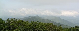
Brasstown Bald is the highest point in the U.S. state of Georgia. It is located in the northeastern part of the state in the Blue Ridge Mountains on the border between Towns and Union counties south of the city of Hiawassee. The mountain is known to the native Cherokee people as Enotah.
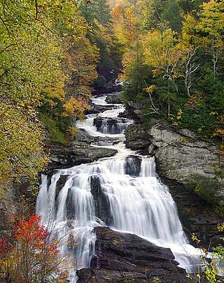
The Nantahala National Forest is the largest of the four national forests in North Carolina, lying in the mountains and valleys of western North Carolina. The Nantahala is the second wettest region in the country, after the Pacific Northwest. Due to its environmental importance and historical ties with the Cherokee, the forest was officially established on January 29, 1920, by President Woodrow Wilson. The word "Nantahala" is a Cherokee derived, meaning "Land of the Noonday Sun." In some spots, the sun reaches the floors of the deep gorges of the forest only when it is high overhead at midday. This was part of the homeland of the historic Cherokee and their indigenous ancestors, who have occupied the region for thousands of years.

State Route 2 (SR 2) is a 165-mile-long (266 km) east-west State highway in the far North-northern part of Georgia. The highway serves southern suburbs of Chattanooga, Tennessee, as well as much of the mountains in the northern part of the state. It traverses the counties of Walker, Catoosa, Whitfield, Murray, Gilmer, Fannin, Union, Towns, and Rabun. It connects Flintstone, in the northwestern part of the state, with the South Carolina state line southeast of Clayton in the northern part and the northeastern part of the state. It also travels through Fort Oglethorpe, Ringgold, Ellijay, Blue Ridge, Blairsville, and Hiawassee. Parts of the highway in the Whitfield and Murray county area are designated as the Cohutta–Chattahoochee Scenic Byway.
State Route 17 (SR 17) is a 300-mile-long (480 km) state highway that travels northwest–southeast in the east-central and northeastern parts of the U.S. state of Georgia. The highway connects the Savannah metro area to the North Carolina state line, northwest of Hiawassee and runs roughly parallel to the South Carolina state line.

State Route 75 (SR 75) is a 33.4-mile-long (53.8 km) state highway that travels south-to-north through portions of White and Towns counties in the northern part of the U.S. state of Georgia. It connects Cleveland and the North Carolina state line, via Helen, Macedonia, and Hiawassee.
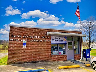
Warne ( "worn") is an unincorporated community in Brasstown Township, Clay County, North Carolina, United States. In 2010, Clay County was the fourth least populated county in North Carolina, inhabited by approximately 10,587 people. The region has added considerably to its population, a 20.6% increase since 2000. Warne is closer to the capitals of five other states than to Raleigh, the capital of North Carolina.
The name Hiwassee is derived from the Cherokee word Ayuhwasi, meaning "savanna" or "large meadow". The name has been applied to several entities past and present in the U.S. states of Georgia, North Carolina, and Tennessee:

U.S. Route 76 (US 76) is a 150.7-mile-long (242.5 km) east–west U.S. highway in the U.S. state of Georgia. It begins at the Tennessee state line, east of Lakeview, Georgia, where the roadway continues concurrent with US-41/SR-8 toward Chattanooga. It ends at the South Carolina state line, where US 76 continues toward Anderson. In Georgia, the highway travels within portions of Catoosa, Whitfield, Murray, Gilmer, Fannin, Union, Towns, and Rabun counties. It travels through North Georgia and connects Ringgold, Dalton, Chatsworth, Ellijay, Blue Ridge, Blairsville, and Clayton. Most of the highway is part of the Lookout Mountain Scenic Highway, a highway that travels through northern Georgia and through the Chattahoochee-Oconee National Forest.

Northeast Georgia is a region of Georgia in the United States. The northern part is also in the north Georgia mountains, while the southern part is still hilly but much flatter in topography. Northeast Georgia is also served by the Asheville/Spartanburg/Greenville/Anderson market.

North Carolina Highway 175 (NC 175) is a primary state highway in the U.S. state of North Carolina. The highway runs north from the Georgia state line to US 64, along the eastern banks of Chatuge Lake.
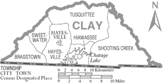
Brasstown is the westernmost township, and one of the six townships of Clay County, North Carolina, United States. The other five are Hayesville, Hiawassee, Shooting Creek, Sweetwater, and Tusquittee. By area, it is the third smallest township in Clay County.
Hayesville is a central township, and one of the six townships of Clay County, North Carolina, United States. The other five are Brasstown, Hiawassee, Shooting Creek, Sweetwater, and Tusquittee.
Sweetwater Township is one of the six townships of Clay County, North Carolina, United States, located in the northwestern part of the county. The other five are Brasstown, Hayesville, Shooting Creek, Hiawassee, and Tusquittee.
Shooting Creek Township is a township and one of the six townships of Clay County, North Carolina, United States, and is the easternmost of the six. The other five are: Brasstown, Hayesville, Sweetwater, Hiawassee, and Tusquittee.
Tusquittee Township is one of the six townships of Clay County, North Carolina, United States and is the northernmost of the six. The other five are Brasstown; Hayesville, which contains the county seat of the same name; Sweetwater, Hiawassee, and Shooting Creek. The name is derived from the Cherokee people, who occupied this area as part of their homeland.
Martin Creek is a stream in the U.S. state of North Carolina. It is a tributary to the Hiwassee River.
The 1931 Western Carolina Yodelers football team represented Western Carolina Teachers College—now known as Western Carolina University—as an independent the 1931 college football season. Led by first-year head coach C. C. Poindexter, Western Carolina compiled a record of 4–4.

