
Clay County is a county located in the far western part of U.S. state North Carolina. As of the 2020 census, the county population was 11,089. The county seat is Hayesville.

Swain County is a county located on the far western border of the U.S. state of North Carolina. As of the 2020 census, the population was 14,117. Its county seat is Bryson City.

Macon County is a county located in the U.S. state of North Carolina. As of the 2020 census, the population was 37,014. Its county seat is Franklin.

Graham County is a county located in the U.S. state of North Carolina. As of the 2020 census, the population was 8,030, making it the third-least populous county in North Carolina. Its county seat is Robbinsville.

Cherokee County is the westernmost county in the U.S. state of North Carolina. It borders Tennessee to its west and Georgia to its south. As of the 2020 census, the population was 28,774. The county seat is Murphy.

Franklin is a town in and the county seat of Macon County, North Carolina, United States. It is situated within the Nantahala National Forest. The population was reported to be 4,175 in the 2020 census, an increase from the total of 3,845 tabulated in 2010.

The Tallulah River is a 47.7-mile-long (76.8 km) river in Georgia and North Carolina. It begins in Clay County, North Carolina, near Standing Indian Mountain in the Southern Nantahala Wilderness and flows south into Georgia, crossing the state line into Towns County. The river travels through Rabun County and ends in Habersham County. It cuts through the Tallulah Dome rock formation to form the Tallulah Gorge and its several waterfalls. The Tallulah River intersects with the Chattooga River to form the Tugaloo River at Lake Tugalo in Habersham County. It joins South Carolina's Seneca River at Lake Hartwell to form the Savannah River, which flows southeastward into the Atlantic Ocean.

The Cherokee National Forest is a United States National Forest located in the U.S. states of Tennessee and North Carolina that was created on June 14, 1920. The forest is maintained and managed by the United States Forest Service. It encompasses an estimated area of 655,598 acres (2,653.11 km2).
The Tellico River is a river in the Blue Ridge Mountains of western North Carolina and eastern Tennessee. It rises in the westernmost mountains of North Carolina, and then flows through Monroe County, Tennessee, before joining the Little Tennessee River under the Tellico Reservoir. With a length of 52.8 miles (85.0 km), it is a major tributary of the Little Tennessee River, and is one of the primary streams draining the Unicoi Mountains.

The Chattooga River is the main tributary of the Tugaloo River.

The Unicoi Mountains are a mountain range rising along the border between Tennessee and North Carolina in the southeastern United States. They are part of the Blue Ridge Mountain Province of the Southern Appalachian Mountains. The Unicois are located immediately south of the Great Smoky Mountains and immediately west of the Cheoah Mountains. Most of the range is protected as a national forest, namely the Cherokee National Forest on the Tennessee side and the Nantahala National Forest on the North Carolina side— although some parts have been designated as wilderness areas and are thus more strictly regulated.

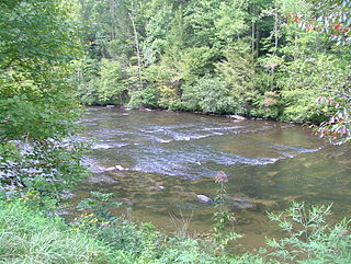
The Nantahala River is a river in western North Carolina in the United States, within the Nantahala National Forest, and near the Great Smoky Mountains National Park. Two-lane U.S. Highway 19/74 runs along the river, picnic areas dotting the route. In 1839, this was an unimproved large path, part of what became known as the Trail of Tears as the Cherokee people were forcibly removed from their homelands in this region to west of the Mississippi River and Indian Territory.

The Chattahoochee–Oconee National Forest in northern Georgia comprises two United States National Forests, the Oconee National Forest in eastern Georgia and the Chattahoochee National Forest located in the North Georgia Mountains. The Chattahoochee National Forest is composed of an eastern and western forest. The western forest contains Johns Mountain, Little Sand Mountain, and Taylor Ridge (Georgia). The combined total area of the Chattahoochee–Oconee National Forest is 867,265 acres (3,510 km2), of which the Chattahoochee National Forest comprises 751,069 acres (3,039 km2) and the Oconee National Forest comprises 116,196 acres (470 km2). The county with the largest portion of the eastern forest is Rabun County, Georgia, which has 148,684 acres (601.7 km2) within its boundaries.
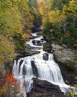
The Nantahala National Forest is the largest of the four national forests in North Carolina, lying in the mountains and valleys of western North Carolina. The Nantahala is the second wettest region in the country, after the Pacific Northwest. Due to its environmental importance and historical ties with the Cherokee, the forest was officially established on January 29, 1920, by President Woodrow Wilson. The word "Nantahala" is a Cherokee derived, meaning "Land of the Noonday Sun." In some spots, the sun reaches the floors of the deep gorges of the forest only when it is high overhead at midday. This was part of the homeland of the historic Cherokee and their indigenous ancestors, who have occupied the region for thousands of years.

Joyce Kilmer-Slickrock Wilderness, created in 1975, covers 17,394 acres (70 km2) in the Nantahala National Forest in western North Carolina and the Cherokee National Forest in eastern Tennessee, in the watersheds of the Slickrock and Little Santeetlah Creeks. It is named after Joyce Kilmer, author of "Trees." The Little Santeetlah and Slickrock watersheds contain 5,926 acres (23.98 km2) of old growth forest, one of the largest tracts in the United States east of the Mississippi River.

Del Rio is an unincorporated community in Cocke County, Tennessee, United States. Although it is not a census-designated place, the ZIP Code Tabulation Area for the ZIP Code (37727) that serves Del Rio had a population of 2,138, according to the 2000 census.

Wayah Bald is a high-altitude treeless open area in Nantahala National Forest, near Franklin, North Carolina. The Wayah Bald Observation Tower is located at the area's highest point ; the stone observation tower was built by the Civilian Conservation Corps in 1937 for fire detection. The Appalachian Trail and Bartram Trail cross at Wayah Bald.

Wesser Bald is a summit located in Macon County, North Carolina, near the community of Wesser. A wooden fire tower at the summit provides hikers with unimpeded views of the Great Smoky Mountains National Park and also the Nantahala Mountains. The Appalachian Trail traverses the summit from roughly north to south with the Nantahala Outdoor Center lying to the north within the Nantahala Gorge and Tellico gap just to the south. Tellico gap has unimproved road access. The climb from Tellico Gap takes an average of 20 minutes. Also, a third route, the blue trail, departs from the end of Wesser Creek Road and follows Wesser Creek up to a point just south of the summit to a fork with the Appalachian Trail. The summit is located at 4,627 ft (1,410 m). and is within Nantahala National Forest. A map detailing the highway routes to access Tellico Gap is available at the Nantahala Outdoor Center. Observable landforms include Wayah Bald, the Nantahala Gorge, and Clingmans Dome among others. The Wesser Fire Tower provides 360 degree views of the Smokies in a short 1.5 mile hike from Tellico Gap on the Appalachian Trail, with an elevation gain of about 767 feet. The Fire Tower was originally reported as destroyed during the forest fires which ravaged the Nantahala Forest in November, 2016 but it was later learned that it survived.

Fires Creek is a recreational area located in the Nantahala National Forest in Clay County, North Carolina. It takes its name from Fires Creek, which runs through it. The creek was named for the first white settler who lived in the area. The area offers paved and unpaved hiking trails, swimming holes, camping spots, picnic tables, grills, scenic views, horseback riding, fishing. Fires Creek Recreation Area is an active bear sanctuary.

Nantahala Township is located in North Carolina, United States in the part of Macon County which is west of Wayah Gap. It has a population of 1,711. "Nantahala" is a Cherokee word which means "The sun between them".

