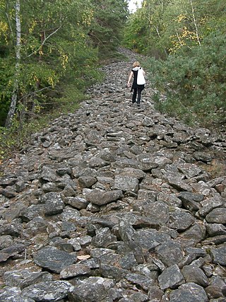
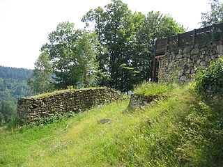
The Celtic hill fort of Otzenhausen is one of the biggest fortifications the Celts ever constructed. It was built by Gauls of the Treveri tribe, who lived in the region north of the fort. The fort is located on top of the Dollberg, a hill near Otzenhausen in Germany, about 695 m above sea level. The only visible remains are two circular earth ramparts, covered with stones.
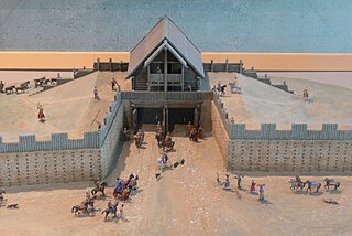
Reconstructed Celtic buildings at OtzenhausenReconstructed Celtic house at Otzenhausen
In times of war, the circular rampart was a strong fortification against enemies. Theories suggest this one might have been more than just a refuge. There might have been a permanent settlement, a village or the seat of a local leader.
The first fortification was constructed in the 5th or 4th century BC, but the real heyday of construction dates to the 2nd and 1st century BC. For reasons yet unknown, the fort was abandoned shortly after this expansion.
Description
The site is formed in the shape of a triangle with rounded ends. One rampart surrounds the whole fort. On the southern side, another similar embankment is built about 40 metres in front of the main one. The ends of this outer rampart approach the main one but do not touch it. Because the entrance of the main rampart is located on the western side, no significant purpose for the outer one has been determined. From west to east the fort extends 460 m, from north to south 647 m. The total length of the ramparts is 2500 metres and they contain 240,000 cubic metres of stone. Thousands of beams were attached to the ramparts which, as the diagram shows, probably presented a vertical stone wall to the exterior.
Design of a Celtic defensive wall. (See: Murus Gallicus)
But this is usually the form of all the Gallic walls. Straight beams, connected lengthwise and two feet distant from each other at equal intervals, are placed together on the ground; these are mortised on the inside, and covered with plenty of earth. But the intervals which we have mentioned, are closed up in front by large stones. These being thus laid and cemented together, another row is added above, in such a manner that the same interval may be observed, and that the beams may not touch one another, but equal spaces intervening, each row of beams is kept firmly in its place by a row of stones. In this manner the whole wall is consolidated, until the regular height of the wall be completed. This work, with respect to appearance and variety, is not unsightly, owing to the alternate rows of beams and stones, which preserve their order in right lines; and, besides, it possesses great advantages as regards utility and the defence of cities; for the stone protects it from fire, and the wood from the battering ram, since it (the wood) being mortised in the inside with rows of beams, generally forty feet each in length, can neither be broken through nor torn asunder.[1]
On the western side, there was a gateway, build of wood, standing on eight posts. This gateway was double-winged and 6 m wide. A central post divided the gateway into two gates of 2.5 m each. The wooden posts sunk into the holes of the gatepost were wedged with stones. Broken rock on the ground prevented the earth from being washed away.
Perhaps there was a second gate on the eastern side, but its existence is not yet proven.
From other examples of Celtic forts, it is known that the gateway presumably was a canopied wooden battlement. Because this gateway is built to the inner side of the wall, the ends of the wall and the battlement form a small square, which can be attacked from three sides without leaving cover.
Important for the use of the fort is the existence of a spring on the top of the Dollberg. This spring is a result of the impermeable quartzite the ground consists of.
Holes in the ground, sockets for the wooden posts, prove the existence of buildings. It is unknown whether the buildings' purpose was accommodation or storage.
Aftermath
In the Roman times a small temple of 2.15 x 2.70 metres, dating to the 2nd or 3rd century A.D. was built of quartzite rubble stone and brick-shaped sandstone. When Germanic tribes invaded the Roman territories in 4th century A.D, the fort was used again.
During the Thirty Years War (1618–1648) the inhabitants of the surrounding villages again took refuge in the remains of the Celtic fort.
The first documented appearance of the circular ramparts occurred within the Grimburger Salbuch, a geological register of 1589, the first picture of the enclosure in the Gazette de Metz from 1836.
The same year, Count Villers von Burgesch addressed a petition to the Prussian king Friedrich Wilhelm III to bar the inhabitants of the nearby villages to carry off stones for use as building material. Reacting to this petition the Crown Prince, later King Friedrich Wilhelm IV visited the fort in 1837.
Excavations took place in 1883 and from 1936 to 1939.
Present
The site can be visited all year round, but is without access for handicapped persons. Three information paths lead through the fort:
A multilingual (D, GB, F, NL) illustrated archaeological information path leads to the most interesting sites of the fortification.
There is also an adventure and experience path for children with 9 stations.
The European Path of Sculptures "Cerda&Celtoi" is inspired by Celtic art and culture. The 18 sculptures connect the modern art center of the Europäische Akademie Otzenhausen with the historic center "Hunnenring".
Since 1999 the Terrex GmbH organizes excavations in and around the fortification.
Today the whole area, with the exception of the stone circles, is covered by woods.
A defensive wall is a fortification usually used to protect a city, town or other settlement from potential aggressors. The walls can range from simple palisades or earthworks to extensive military fortifications with towers, bastions and gates for access to the city. From ancient to modern times, they were used to enclose settlements. Generally, these are referred to as city walls or town walls, although there were also walls, such as the Great Wall of China, Walls of Benin, Hadrian's Wall, Anastasian Wall, and the Atlantic Wall, which extended far beyond the borders of a city and were used to enclose regions or mark territorial boundaries. In mountainous terrain, defensive walls such as letzis were used in combination with castles to seal valleys from potential attack. Beyond their defensive utility, many walls also had important symbolic functions – representing the status and independence of the communities they embraced.
A palisade, sometimes called a stakewall or a paling, is typically a row of closely placed, high vertical standing tree trunks or wooden or iron stakes used as a fence for enclosure or as a defensive wall. Palisades can form a stockade.
A hillfort is a type of earthwork used as a fortified refuge or defended settlement, located to exploit a rise in elevation for defensive advantage. They are typically European and of the Bronze Age or Iron Age. Some were used in the post-Roman period. The fortification usually follows the contours of a hill and consists of one or more lines of earthworks, with stockades or defensive walls, and external ditches. If enemies were approaching, the civilians would spot them from a mile away.
A fortification is a military construction designed for the defense of territories in warfare, and is used to establish rule in a region during peacetime. The term is derived from Latin fortis ("strong") and facere.
A Viking ring fortress, or Trelleborg-type fortress, is a type of circular fort of a special design, built in Scandinavia during the Viking Age. Collectively, they may also be known as trelleborgs. These fortresses have a strictly circular shape, with roads and gates pointing in the four cardinal directions. They are sometimes partially encircled by advanced ramparts, though not always circular.
An oppidum is a large fortified Iron Age settlement or town. Oppida are primarily associated with the Celtic late La Tène culture, emerging during the 2nd and 1st centuries BC, spread across Europe, stretching from Britain and Iberia in the west to the edge of the Hungarian plain in the east. These settlements continued to be used until the Romans conquered Southern and Western Europe. Many subsequently became Roman-era towns and cities, whilst others were abandoned. In regions north of the rivers Danube and Rhine, such as most of Germania, where the populations remained independent from Rome, oppida continued to be used into the 1st century AD.
The Grianan of Aileach, sometimes anglicised as Greenan Ely or Greenan Fort, is a hillfort atop the 244 metres (801 ft) high Greenan Mountain at Inishowen in County Donegal, Ireland. The main structure is a stone ringfort, thought to have been built by the Northern Uí Néill, in the sixth or seventh century CE; although there is evidence that the site had been in use before the fort was built. It has been identified as the seat of the Kingdom of Ailech and one of the royal sites of Gaelic Ireland. The wall is about 4.5 metres (15 ft) thick and 5 metres (16 ft) high. Inside it has three terraces, which are linked by steps, and two long passages within it. Originally, there would have been buildings inside the ringfort. Just outside it are the remains of a well and a tumulus.
Mamucium, also known as Mancunium, is a former Roman fort in the Castlefield area of Manchester in North West England. The castrum, which was founded c. AD 79 within the Roman province of Roman Britain, was garrisoned by a cohort of Roman auxiliaries near two major Roman roads running through the area. Several sizeable civilian settlements containing soldiers' families, merchants and industry developed outside the fort. The area is a protected Scheduled Ancient Monument.
Murus gallicus or Gallic wall is a method of construction of defensive walls used to protect Iron Age hillforts and oppida of the La Tene period in Western Europe.
A Pfostenschlitzmauer is the name for defensive walls protecting Bronze Age and Iron Age hill forts and oppida in Central Europe, especially in Bavaria and the Czech Republic. They are characterized by vertical wooden posts set into the front stone facing. The rampart is constructed from a timber lattice filled with earth or rubble. The transverse cross-beams may also protrude through the stone facing, as with the murus gallicus used in Gaul and western Germany. It is sometimes referred to in English as a timber-framed wall.
Vindobala was a Roman fort at the modern-day hamlet of Rudchester, Northumberland. It was the fourth fort on Hadrian's Wall, after Segedunum (Wallsend), Pons Aelius (Newcastle) and Condercum (Benwell). It was situated about 11 kilometres (6.8 mi) to the west of Condercum. The site of the fort is bisected by the B6318 Military Road, which runs along the route of the wall at that point.
A circular rampart is an embankment built in the shape of a circle that was used as part of the defences for a military fortification, hill fort or refuge, or was built for religious purposes or as a place of gathering.
Crosskirk Broch was a fortification near the present day hamlet of Crosskirk near Thurso, Caithness, Scotland. After thorough archaeological exploration it was destroyed in 1972 since the site had become unsafe due to sea erosion. The site was unusual in having a broch, a large circular fortification, built within an older promontory fortification with a ring wall and blockhouse.
Milecastle 50TW (High House) was a milecastle on the Turf Wall section of Hadrian's Wall (grid reference NY60716583). The milecastle is located close to the Birdoswald Roman Fort and is unique in that it was not replaced by a stone milecastle when the turf wall was upgraded to stone, the replacement wall instead running some 200m to the north. The milecastle was partially demolished by the Romans after it was abandoned. The milecastle was excavated in 1934 and several Roman rubbish pits discovered. The remains of the two turrets associated with this milecastle (which were demolished when the turf wall was abandoned) have also been located. As the turf wall lies some distance from the stone wall, the sites are not accessible from the Hadrian's Wall Path.
The Heidenmauer near the Palatine county town of Bad Dürkheim in the German state of Rhineland-Palatinate is a circular rampart or ringwork, two and a half kilometres long, which was built by the Celts around 500 B. C. as a type of Murus Gallicus but was pulled down again not long afterwards. The wooden elements of the wall have disappeared over the course of time by rotting away, but the stones have survived.
Traiectum was a Roman fort, on the frontier of the Roman Empire in Germania Inferior. The remains of the fort are in the center of Utrecht, Netherlands, which takes its name from the fort.
Wildenburg Castle is a ruined castle near Kempfeld in the county of Birkenfeld in the German state of Rhineland-Palatinate.
Burghead Fort was a Pictish promontory fort on the site now occupied by the small town of Burghead in Moray, Scotland. It was one of the earliest power centres of the Picts and was three times the size of any other enclosed site in Early Medieval Scotland. The fort was probably the main centre of the Pictish Kingdom of Fortriu, flourishing with the kingdom itself from the 4th to the 9th centuries.
The Heunischenburg is a stone fortification of the late Urnfield period near the Upper Franconian town of Kronach in Germany. Its heyday was in the 9th century BC, making it the oldest stone fortification north of the Alps that is known and archaeologically investigated.
Bjelaj Fortress, locally known as Stari Grad Bjelaj, is a medieval town-fortress complex near the village of Bjelaj, Bosanski Petrovac, Bosnia and Herzegovina.
This page is based on this Wikipedia article Text is available under the CC BY-SA 4.0 license; additional terms may apply. Images, videos and audio are available under their respective licenses.