Birkenfeld is a district (Landkreis) in Rhineland-Palatinate, Germany. Its seat is the town of Birkenfeld. It is bounded by the districts of Sankt Wendel (Saarland), Trier-Saarburg, Bernkastel-Wittlich, Rhein-Hunsrück, Bad Kreuznach and Kusel.
Sankt Wendel is a Kreis (district) in the north of the Saarland, Germany. Neighboring districts are Trier-Saarburg, Birkenfeld, Kusel, Neunkirchen, Saarlouis, and Merzig-Wadern.

Sankt Wendel[zaŋkt ˈvɛndl̩] is a town in northeastern Saarland. It is situated on the river Blies 36 km northeast of Saarbrücken, the capital of Saarland, and is named after Saint Wendelin of Trier. According to a survey by the German Association for Housing, Town Planning and Land Use Regulation, St. Wendel is known to be one of the wealthiest regions in Germany, behind Starnberg in Bavaria.

St. Ingbert is a town in the Saarpfalz district in Saarland, Germany with a population of 37,361 (2009). It is situated approximately 10 km north-east of Saarbrücken and 10 km south-west of Neunkirchen.
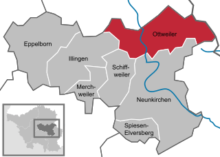
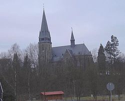
Ottweiler is a municipality, former seat of the district of Neunkirchen, in Saarland, Germany. It is situated on the river Blies, approx. 7 km north of Neunkirchen, and 25 km northeast of Saarbrücken.

Großrosseln is a village and a municipality in the district of Saarbrücken, in Saarland, Germany. It is situated on the border with France, approximately 12 km west of Saarbrücken. The neighbouring municipality in France is Petite-Rosselle.

Kleinblittersdorf is a village and a municipality in the district of Saarbrücken, in Saarland, Germany. It is situated on the river Saar, opposite Grosbliederstroff in France, approx. 10 km south of Saarbrücken.

Bexbach is a town in the Saarpfalz district, in Saarland, Germany. It is situated on the river Blies, approximatively 6 km east of Neunkirchen, and 25 km northeast of Saarbrücken. The Saarländisches Bergbaumuseum is located in the town.

Blieskastel is a city in the Saarpfalz (Saar-Palatinate) district, in Saarland, Germany which is divided into villages. It is situated on the river Blies, approximately 10 kilometres southwest of Homburg (Saar), 8 km (5 mi) west of Zweibrücken, and 20 km (12 mi) east of Saarbrücken.

Freisen is a municipality in the district of Sankt Wendel, in Saarland, Germany. It is situated approximately 12 km northeast of Sankt Wendel, and 20 km southwest of Idar-Oberstein. The public transportation in Freisen/Oberkirchen is through bus and connects to other towns via transfers in Sankt Wendel and Neunkirchen.

Marpingen is a municipality in the district of Sankt Wendel, in Saarland, Germany. It is situated approximately 8 km west of Sankt Wendel, and 25 km north of Saarbrücken.

Namborn is a municipality in the district of Sankt Wendel, in Saarland, Germany. It is situated approximately 7 km north of Sankt Wendel, and 25 km southwest of Idar-Oberstein. It is approximately 40 km northeast of Saarbrücken on highway B 41 and the Nahe Valley Railway line. The distance to the Bostalsee is about 10 km, and to the county seat St. Wendel about 7 km.

Nohfelden is a municipality in the district of Sankt Wendel, in Saarland, Germany. It is situated approximately 15 kilometres (9.3 mi) north of Sankt Wendel, and 20 kilometres (12 mi) southwest of Idar-Oberstein. It was formed during administrative reform in January 1974 from the merger of 13 previously independent municipalities.

Oberthal is a municipality in the district of Sankt Wendel, in Saarland, Germany. It is situated approximately 7 km northwest of Sankt Wendel, and 35 km north of Saarbrücken.

Tholey is a municipality in the district of Sankt Wendel, in Saarland, Germany. It is situated approximately 10 kilometres (6.2 mi) west of Sankt Wendel, and 30 kilometres (19 mi) north of Saarbrücken.

Achtelsbach is an Ortsgemeinde – a municipality belonging to a Verbandsgemeinde, a kind of collective municipality – in the Birkenfeld district in Rhineland-Palatinate, Germany. It belongs to the Verbandsgemeinde of Birkenfeld, whose seat is in the like-named town.
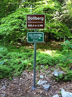
The Dollberg is a mountain in the Dollberge range in central Germany and the highest point in the state of Saarland. It is 695.4 m above sea level (NHN) and lies within the Schwarzwälder Hochwald on the boundary between the counties of Trier-Saarburg (Rhineland-Palatinate) and St. Wendel (Saarland).

St. Wendel is an electoral constituency represented in the Bundestag. It elects one member via first-past-the-post voting. Under the current constituency numbering system, it is designated as constituency 298. It is located in northeastern Saarland, comprising the Sankt Wendel district, the northern part of the Neunkirchen district, and parts of the Saarlouis and Saarbrücken districts.

Andrea Neumann was a German visual artist and educator. She is one of the most important artists of the Saarland region. She is known for her abstract paintings.