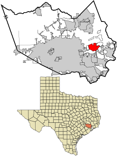
Channelview is a census-designated place (CDP) in the U.S. state of Texas on the eastside of Houston, Harris County. The population was 45,688 at the 2020 U.S. census.

Cloverleaf is a census-designated place (CDP) in east central Harris County, Texas, United States. The population was 24,100 at the 2020 census.
Pauline is an unincorporated community and census-designated place (CDP) in Spartanburg County, South Carolina, United States. It was first listed as a CDP in the 2020 census with a population of 209.
Genoa is an unincorporated community and census-designated place (CDP) in Miller County, Arkansas, United States. It was first listed as a CDP in the 2020 census with a population of 972. It is located 6 to 12 miles east of Texarkana along Highway 196. Although unincorporated, Genoa has a post office, with the ZIP code of 71840 for a specific post office box. Most of the community is served by ZIP code 71854 (Texarkana). Genoa also has its own school district, Genoa Central School District.
Solon Mills is an unincorporated community and census-designated place in McHenry County, Illinois, United States. Solon Mills is located on U.S. Route 12, 2 miles (3.2 km) southwest of Spring Grove. Solon Mills is part of ZIP code 60071; it once had its own post office with ZIP code 60080 before it closed on September 28, 2002. It was named a CDP prior to the 2020 census which showed a population of 133.

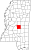
Scott is a census-designated place and unincorporated community located in Bolivar County, Mississippi, United States on Mississippi Highway 1. Scott is approximately 5 miles (8.0 km) north of Lamont and approximately 7 miles (11 km) south of Benoit.
Centerville is an unincorporated community and census-designated place (CDP) in Yell County, Arkansas, United States. Centerville is located at the junction of Arkansas Highways 7 and 154, 6.5 miles (10.5 km) north-northeast of Ola. It was first listed as a CDP in the 2020 census with a population of 283.
Boles is an unincorporated community and census-designated place (CDP) in Scott County, Arkansas, United States. It was first listed as a CDP in the 2020 census with a population of 166.
Morrow is an unincorporated community and census-designated place (CDP) in Washington County, Arkansas, United States. It was first listed as a CDP in the 2020 census with a population of 263.
Buckatunna is a census-designated place (CDP) and unincorporated community located in Wayne County, Mississippi, United States. The population was 383 at the 2020 census. Buckatunna is located in the southeast corner of Wayne County, just west of the Alabama state line. Buckatunna has a post office with the zip code 39322.

Adams Run is an unincorporated community and census-designated place (CDP) in Charleston County, South Carolina, United States. It was first listed as a CDP in the 2020 census with a population of 421.
Nicholson is an unincorporated community and census-designated place (CDP) in Pearl River County, Mississippi, United States. As of the 2020 census, its population was 2,833. Its ZIP code is 39463.
Toomsuba is a census-designated place (CDP) and unincorporated community in Lauderdale County, Mississippi, United States. Its population was 778 as of the 2020 census. Its ZIP code is 39364.
Pattison, also known as Martin, is a census-designated place and unincorporated community in Claiborne County, Mississippi, United States. Its ZIP code is 39144.
Remlap is a census-designated place in Blount County, Alabama, United States, located along Alabama State Route 75, 11.7 miles (18.8 km) southwest of Oneonta. Remlap has a post office with ZIP code 35133.
Harperville is a census-designated place and unincorporated community in rural Scott County, Mississippi, United States. Harperville is located on Mississippi Highway 35, 9 miles (14 km) north of Forest. Harperville has a post office with ZIP code 39080.
La France is an unincorporated community and census-designated place (CDP) in Anderson County, South Carolina, United States. It was first listed as a CDP in the 2020 census with a population of 476.
Trout is an unincorporated community and census-designated place in La Salle Parish, Louisiana, United States. The community is located on U.S. Route 84, 2.8 miles (4.5 km) west of Jena. Trout has a post office with ZIP code 71371.
Axson is a census-designated place in Atkinson County, Georgia, United States. The community is located on U.S. Route 82, 7.1 miles (11.4 km) east of Pearson. Axson has a post office with ZIP code 31624. Per the 2020 Census, the population was 360.

Elliott is an unincorporated community and census-designated place (CDP) in Lee County, South Carolina, United States. It was first listed as a CDP in the 2020 census with a population of 370.