Hillsgrove, Rhode Island

Last updated

Hillsgrove State Airport Terminal, Warwick (1932) Old Terminal Rhode Island.jpg
Hillsgrove State Airport Terminal, Warwick (1932)

Hillsgrove, originally Hill's Grove, is a village in western central Warwick, Rhode Island. [1]

The village was established in 1867. It consists of the area of Warwick centered on the intersection of Kilvert Street and Jefferson Boulevard, on both sides of the railroad tracks. Directly north of the village proper is North Hillsgrove, a typical early to mid-twentieth century suburban neighborhood.

In 1867 industrialist Thomas Jefferson Hill built the Rhode Island Malleable Iron Works at what is today Jefferson Boulevard and Kilvert Street. [2] In 1870, he built his house, now demolished, on Jefferson Boulevard. [3] In 1875, Hill expanded his operations in the village with the Elizabeth Mill, named for his wife, Elizabeth C. Kenyon. [4]

The Hillsgrove Methodist Episcopal Church was established in 1884. The lot at 35 Kilvert Street was donated by Hill, who also gave $3,000 for its construction in 1887. Though altered due to the airport's presence, the church still stands as the home of the Open Table of Christ. [5] The village's other main church, St. Francis of Assisi Roman Catholic Church, was established in 1899 as a mission of St. Joseph's, Natick. The original church was built in 1900 at 610 Jefferson Boulevard. This building was torn down in 1960 for the parish's current school and church building. [6] By 1915, the original Hillsgrove School had become too small, and was replaced by one designed by Thomas J. Hill Pierce of Providence. This school, a reserved Colonial Revival structure, has been demolished. [7] In 1918, the original buildings of the Iron Works burned, and were replaced by a group designed by Jackson, Robertson & Adams of Providence. [8] With the exception of the administration building, these buildings were demolished in 2002 for a hotel.

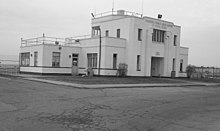
In 1929, Hillsgrove was selected as the site of Hillsgrove State Airport, now T. F. Green Airport, the largest and most important airport in the state. The airport's first terminal was built in 1932 at 572 Airport Road, a year after the airport opened in 1931. Hangars No. 1 and No. 2 were built in 1937 and 1940, respectively. [9] Hangar No. 1 was demolished for a runway extension in 2013. A new terminal was built in 1961 on Post Road across from Hillsgrove proper. [10] This terminal was replaced in 1995. The most recent addition to the airport is the railway station and parking garage on Jefferson Boulevard, connected to the terminal by a quarter-mile skybridge.

Leviton Manufacturing formerly operated a large factory here, fabricating electronic components for many years. The Elizabeth Mill, which housed Leviton, was slated for redevelopment but was demolished in 2015. [11] [12]

The major thoroughfares in the village are Post Road, Jefferson Boulevard, and Coronado Road/Kilvert Street. Since the airport was opened, Hillsgrove south of Coronado Road has been gradually given over to industry, to the point where there are only 2 houses left. The northern end of Jefferson Boulevard has also become an industrial park. And the once predominantly residential Post Road has been given over to chain restaurants, hotels, car rental dealerships, and other businesses that feed off of the airport.

Related Research Articles

<span class="mw-page-title-main">Warwick, Rhode Island</span> City in Rhode Island, United States

Warwick is a city in Kent County, Rhode Island, United States, and is the third largest city in the state with a population of 82,823 at the 2020 census. Warwick is located approximately 12 miles (19 km) south of downtown Providence, Rhode Island, 63 miles (101 km) southwest of Boston, Massachusetts, and 171 miles (275 km) northeast of New York City.

<span class="mw-page-title-main">West Warwick, Rhode Island</span> Town in Rhode Island, United States

West Warwick is a town in Kent County, Rhode Island, United States. The population was 31,012 at the 2020 census.

<span class="mw-page-title-main">Wakefield, Rhode Island</span> Village in Rhode Island, United States

Wakefield is a village in the town of South Kingstown, Rhode Island, United States, and the commercial center of South Kingstown. Together with the village of Peace Dale, it is treated by the U.S. Census as a component of the census-designated place identified as Wakefield-Peacedale, Rhode Island. West Kingston, another South Kingstown village, was the traditional county seat of Washington County. Since 1991, the Washington County Courthouse has been in Wakefield. The Sheriff's Office which handles corrections is also in Wakefield.

<span class="mw-page-title-main">Rhode Island Route 37</span> State highway in Rhode Island, US

Route 37 is a state highway running 3.47 miles (5.58 km) in Providence County and Kent County, Rhode Island, United States. A freeway for its entire length, it serves the cities of Cranston and Warwick and is also a major east–west freeway in the Providence metropolitan area, linking T. F. Green Airport with Interstate 295. The western terminus of Route 37 is an at-grade intersection with Natick Avenue in Cranston. The freeway has numbered interchanges with I-295, Rhode Island Route 2, Pontiac Avenue, and I-95 before terminating at a trumpet interchange with U.S. Route 1 in Warwick.

<span class="mw-page-title-main">America's Most Endangered Places</span> List by the U.S. National Trust for Historic Preservation

America's 11 Most Endangered Places or America's 11 Most Endangered Historic Places is a list of places in the United States that the National Trust for Historic Preservation considers the most endangered. It aims to inspire Americans to preserve examples of architectural and cultural heritage that could be "relegated to the dustbins of history" without intervention.

<span class="mw-page-title-main">Stone ender</span> Style of Rhode Island architecture

The stone-ender is a unique style of Rhode Island architecture that developed in the 17th century where one wall in a house is made up of a large stone chimney.

Norwood is a neighborhood in the city of Warwick, Rhode Island. Norwood is bounded by Route 37, the Pawtuxet River, Sherwood Avenue, the former Christopher Rhodes Elementary School, North Palm Boulevard, Palm Boulevard, and Post Road. Such borders mark the area traditionally served by the fire station previously located at the current site of the Norwood Boys & Girls Club.

<span class="mw-page-title-main">Rhode Island State Airport Terminal</span> United States historic place

The Rhode Island State Airport Terminal is a historic airport terminal located on Airport Road in Warwick, Rhode Island, at what is now known as T. F. Green Airport. It was constructed in 1932, and added to the National Register of Historic Places on August 18, 1983.

<span class="mw-page-title-main">Knight Estate</span> Historic house in Rhode Island, United States

The Knight Estate is a historic estate in Warwick, Rhode Island, that is home to the Knight Campus of the Community College of Rhode Island. Developed as a country estate for a family of industrialists and later donated to the state, the main house and its outbuildings were listed on the United States National Register of Historic Places in 1984.

<span class="mw-page-title-main">Warwick Civic Center Historic District</span> Historic district in Rhode Island, United States

The Warwick Civic Center Historic District is a historic district encompassing three buildings at the civic heart of Warwick, Rhode Island.

The city of Woonsocket in the U.S. state of Rhode Island was established as a union of six mill villages along the Blackstone River. These villages are described in more detail below.

The Airport Connector Road, also known as the T. F. Green Airport Connector Road or simply the T. F. Green Airport Connector, is a short, unnumbered highway in the U.S. state of Rhode Island that connects Interstate 95 (I-95) with T. F. Green Airport. The route, which is 1.1 miles (1.8 km) long, is a limited-access freeway for its entire length. The road is situated entirely in the city of Warwick, and is accessible from Interstate 95 via exit 13. The Airport Connector Road has two eastbound interchanges with Jefferson Boulevard and Post Road before terminating at the Bruce Sundlun Terminal of T. F. Green Airport.

<span class="mw-page-title-main">St. Mary's Church (Newport, Rhode Island)</span> Historic church in Rhode Island, United States

St. Mary's Church, officially the Church of the Holy Name of Mary, Our Lady of the Isle, is a historic Catholic parish church complex at 14 William Street, the corner of Spring Street and Memorial Boulevard, in Newport, Rhode Island within the Diocese of Providence. It is the church of the oldest Catholic parish in the state. The church is also notable for hosting the wedding of Jacqueline Bouvier and Senator, later President, John F. Kennedy in 1953.

<span class="mw-page-title-main">Clifton A. Hall</span> American architect

Clifton A. Hall (1826-1913) was an American architect from Providence, Rhode Island.

<span class="mw-page-title-main">Alfred Stone (architect)</span> American architect (1834 - 1908)

Alfred Stone was an American Architect. He was a founding partner of the Providence, Rhode Island, firm of Stone, Carpenter & Willson. Mr. Stone was best known for designing many prominent Rhode Island buildings, including the Providence Public Library, Union Station, buildings at Brown University and the University of Rhode Island, and many private homes.

<span class="mw-page-title-main">William R. Walker & Son</span>

William R. Walker & Son was an American architectural firm in Providence, Rhode Island, active during the years 1881 to 1936. It included partners William Russell Walker (1830–1905), William Howard Walker (1856–1922) and later William Russell Walker II (1884–1936).

<span class="mw-page-title-main">Jackson, Robertson & Adams</span> American architectural firm based in Rhode Island, USA

Jackson, Robertson & Adams was an architectural firm out of Providence, Rhode Island. Established in 1912, it was originally made up of architects F. Ellis Jackson (1879–1950), Wayland T. Robertson (1873–1935), and J. Howard Adams (1876–1924).

Lincoln Park is a neighborhood in Warwick, Rhode Island. It was established early in the twentieth century.

Howard Hoppin was an American architect from Providence, Rhode Island.

<span class="mw-page-title-main">Franklin J. Sawtelle</span> American architect

Franklin J. Sawtelle (1846–1911) was an American architect practicing in Providence, Rhode Island. He was known primarily as a designer of private residences.

References

  1. U.S. Geological Survey Geographic Names Information System: Hillsgrove, Rhode Island
  2. Warwick's Villages: Glimpses from the Past (Donald A. D'Amato, 2009)
  3. "Historical Houses of Warwick, RI". Archived from the original on December 8, 2013. Retrieved December 15, 2013.
  4. Warwick, Rhode Island: Statewide Historical Preservation Report K-W-1 (Rhode Island Historical Preservation Commission, April 1981)
  5. Warwick's Villages: Glimpses from the Past (Donald A. D'Amato, 2009)
  6. "History : St. Francis of Assisi Parish". Archived from the original on December 15, 2013.
  7. The American Contractor (March 13, 1915)
  8. Warwick, Rhode Island: Statewide Historical Preservation Report K-W-1 (Rhode Island Historical Preservation Commission, April 1981)
  9. Warwick's Villages: Glimpses from the Past (Donald A. D'Amato, 2009)
  10. "中国女人内谢69xxxx免费,狠狠色丁香久久婷婷综合五月,亚洲区欧美区综合区自拍区,亚洲自偷拍精品日韩另".
  11. Warwick Works to Preserve Old Mill Building on Leviton Property (Barbara Polichetti for The Providence Journal, October 24, 2012)
  12. "Elizabeth Mill demolition begins". February 4, 2015.

41°43′34″N71°26′21″W / 41.72611°N 71.43917°W / 41.72611; -71.43917