In the 1830s, a Mr. Hollenbeck, who lived near Ottawa, Illinois, was traveling the then-unsettled territory. He found a grove of trees west of the present-day Hinckley and named it Squaw Grove, after the Native American women who were tending camp.[2]
In the spring of 1835, John Sebree built a log house. The following year, more families came to the area and a small town was started at the west edge of what is now Hinckley, which was named Squaw Grove.[3]
Hinckley was conceived in the 1870s as the brainchild of Francis Hinckley, president of the Chicago and Iowa Railroad. The rail line was placed one-half mile east of the Village of Squaw Grove, which was then named Hinckley.[3]
The first store came to Hinckley in 1872. By 1876, Hinckley had twenty businesses.[3]
The Methodist Church began in 1835, and St. Paul's Church came in 1885. A volunteer fire brigade was organized in 1886.[3]
In 1889, a tornado destroyed most of the village.[3]
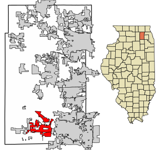
According to the 2021 census gazetteer files, Hinckley has a total area of 0.86 square miles (2.23km2), of which 0.85 square miles (2.20km2) (or 99.06%) is land and 0.01 square miles (0.03km2) (or 0.94%) is water.[7]
As of the 2020 census[9] there were 2,006 people, 878 households, and 556 families residing in the village. The population density was 2,346.20 inhabitants per square mile (905.87/km2). There were 830 housing units at an average density of 970.76 per square mile (374.81/km2). The racial makeup of the village was 89.38% White, 0.55% African American, 0.10% Native American, 0.95% Asian, 0.10% Pacific Islander, 1.89% from other races, and 7.03% from two or more races. Hispanic or Latino of any race were 8.18% of the population.
There were 878 households, out of which 27.9% had children under the age of 18 living with them, 47.61% were married couples living together, 12.30% had a female householder with no husband present, and 36.67% were non-families. 28.47% of all households were made up of individuals, and 8.20% had someone living alone who was 65 years of age or older. The average household size was 3.15 and the average family size was 2.49.
The village's age distribution consisted of 23.9% under the age of 18, 15.4% from 18 to 24, 20.5% from 25 to 44, 26.5% from 45 to 64, and 13.6% who were 65 years of age or older. The median age was 37.1 years. For every 100 females, there were 102.4 males. For every 100 females age 18 and over, there were 108.4 males.
The median income for a household in the village was $70,278, and the median income for a family was $79,667. Males had a median income of $54,028 versus $35,417 for females. The per capita income for the village was $33,663. About 4.9% of families and 8.9% of the population were below the poverty line, including 5.4% of those under age 18 and 5.7% of those age 65 or over.
Popular culture
In 1981, Hinckley served as a stand-in for fictional North Crawford in Jonathan Demme's film adaptation of Who Am I This Time? by Kurt Vonnegut, Jr.[10]Christopher Walken and Susan Sarandon portray two painfully shy people who find one another through a community theater production of "A Streetcar Named Desire", in which they portray the tempestuous Stanley and Stella Kowalski.
Mulberry Grove is a village in eastern Bond County, Illinois, United States. The population was 520 at the 2020 census.
Caledonia is a village in Caledonia Township, Boone County, Illinois, United States. It is part of the Rockford, Illinois Metropolitan Statistical Area. The population was 183 at the 2020 census.
Poplar Grove is a village located in Poplar Grove and Belvidere Townships, Boone County, Illinois, United States. It is part of the Rockford Metropolitan Statistical Area, and of the gated community Candlewick Lake. The population was 5,049 at the 2020 census.
Louisville is a village in Clay County, Illinois, United States, along the Little Wabash River. The population was 1,136 at the 2020 census. It is the county seat of Clay County.
Sugar Grove is a village in Kane County, Illinois, United States. The population at the 2010 census was 8,997, and in 2018 the estimated population was 9,803.
Spring Grove is a village in McHenry County. Portions of unincorporated Lake County, Illinois also utilize Spring Grove postal addresses. It is a commuter village within the Chicago metropolitan area. Per the 2020 census, the population was 5,487. It is also home to Chain O'Lakes State Park.
Stonefort is a village in Saline and Williamson Counties, Illinois, United States. The population was 297 at the 2010 census.
Grandview is a village in Sangamon County, Illinois, United States. The population was 1,441 at the 2010 census. It is part of the Springfield, Illinois Metropolitan Statistical Area.
Germantown Hills is a village in Woodford County, Illinois, approximately 8 miles (13 km) northeast of Peoria. Germantown Hills is the only incorporated community in Worth Township. As of the 2010 census, the village had a total population of 3,438. Largely an agricultural community until its incorporation in 1954, Germantown Hills is now a growing bedroom community in the Peoria Metropolitan Area.
Finlayson is a city in Pine County, Minnesota, United States. The population was 315 at the 2010 census. The city's area was incorporated from Finlayson Township, the remainder of which is still adjacent to it. https://finlayson.municipalimpact.com/
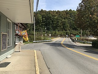
Bruceton Mills is a town in northern Preston County, West Virginia, United States, along Big Sandy Creek. The population was 64 at the 2020 census, making it the second-least populous town in West Virginia, after Thurmond. It is part of the Morgantown metropolitan area.
Yuba is a village in Richland County, Wisconsin, United States. The population was 74 at the 2010 census. Yuba is 11 miles southwest of Hillsboro and 17 miles north of Richland Center. County Hwy C runs through the village.
Elm Grove is a village in Waukesha County, Wisconsin, United States. The population was 6,524 at the 2020 census. Elm Grove was named as America's best suburb by Business Insider in October 2014.
Sullivan is a village in Jefferson County, Wisconsin, United States. The population was 651 at the 2020 census. The village is located within the Town of Sullivan, and is known to residents of southern Wisconsin including the Madison and Milwaukee metro areas as the location of the National Weather Service forecast office MKX, although its mailing address is in nearby Dousman.
Walworth is a village in Walworth County, Wisconsin, United States. The population was 2,759 at the 2020 census. The village is located within the Town of Walworth.
Omro is a city in Winnebago County, Wisconsin, United States. The population was 3,517 at the 2010 census. The city is located along the Fox River, approximately 10 miles west of Oshkosh, Wisconsin.
Big Rock is a village in Kane County, Illinois, United States. It is located approximately 50 miles (80 km) due west of Chicago. It is between the villages of Hinckley and Sugar Grove.
Pierce Township is one of nineteen townships in DeKalb County, Illinois, United States. As of the 2020 census, its population was 440 and it contained 183 housing units. Pierce Township was formed from Squaw Grove and Pampas Township before 1853.
Somonauk Township is one of nineteen townships in DeKalb County, Illinois, USA. As of the 2020 census, its population was 2,006 and it contained 823 housing units.
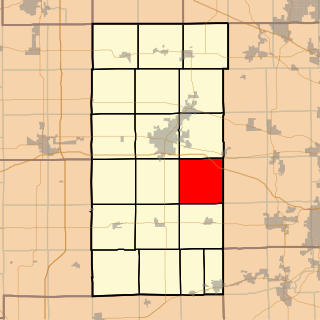
Squaw Grove Township is one of 19 townships in DeKalb County, Illinois, USA. As of the 2020 census, its population was 2,717 and it contained 1,118 housing units.
This page is based on this Wikipedia article Text is available under the CC BY-SA 4.0 license; additional terms may apply. Images, videos and audio are available under their respective licenses.