Kingston, Illinois

Last updated

Kingston
DeKalb County Illinois Incorporated and Unincorporated areas Kingston Highlighted.svg
Location of Kingston in DeKalb County, Illinois.
Illinois in United States (US48).svg
Location of Illinois in the United States
Coordinates: 42°6′0″N88°45′43″W / 42.10000°N 88.76194°W / 42.10000; -88.76194
CountryUnited States
StateIllinois
County DeKalb
Area
[1]
  Total1.01 sq mi (2.61 km2)
  Land0.98 sq mi (2.55 km2)
  Water0.03 sq mi (0.07 km2)
Population
 (2020)
  Total1,108
  Density1,126.02/sq mi (434.83/km2)
Time zone UTC-6 (CST)
  Summer (DST) UTC-5 (CDT)
ZIP Code(s)
60145
Area code 815
FIPS code 17-40065
Wikimedia CommonsKingston, Illinois
Website www.villageofkingston.org

Kingston is a village in DeKalb County, Illinois, United States. The population was 1,108 at the 2020 census, down from 1,164 at the 2010 census.

Contents

History

Settled in 1835 by the Pottawatomie Indians, Kingston was one of the first townships in DeKalb County. The post office was established in 1837 with Levi Lee as postmaster.

The village of Kingston was founded in 1875 when the Chicago & Pacific railroad laid tracks through the township and built a depot on section 22 on a farm belonging to Lyman Stuart, an early settler of Kingston township. Lyman and his brother, James Stuart paid to have the Pleasant Hill church moved to the new site from its original location on Baseline road south of the new village. The Stuart brothers had the village platted in May 1876. The first major fire in the village occurred in January 1886 when several frame buildings were engulfed on the east side of Main street. A farmer, John Uplinger agreed to build a block of brick on the burned site if the citizens would vote to incorporate. An election was held in May 1886 with a question of incorporation on the ballot which resulted in a vote of 69 for incorporation and 17 against. A lumber yard was established by Lyman Stuart in 1876 which Mr. Uplinger purchased from the Stuart estate in 1882. Mr. Uplinger operated the lumber yard until his death in 1892 when control was assumed by his son, B. F. "Frank" Uplinger. The son built a grain elevator in 1892 and in addition to dealing in lumber and grain, he also sold coal & salt. Frank continued this line until 1921 when he sold to the newly formed Kingston Farmers Cooperative. Frank's brother, John H. Uplinger operated a hardware store and sold farm implements and also served as postmaster. Another brother, Charles Uplinger operated the meat market. The citizens voted for a public school house in 1879 which was opened in 1881 and was destroyed by fire in 1895. The second school opened in 1895 and it too was destroyed by fire in 1954. Telephone service came to Kingston in 1898. Indoor plumbing in 1910 and the village was wired for electricity in 1913.

With Kingston being a major "hub" for two railroads business flourished throughout the area. By the 1900s Kingston had many businesses including; a hardware store, department store, grocery, meat market, paint shop, hotel, bank, bakery, shoe store, barber shop, pool room, saloon, general store, creamery, undertaking parlor, saw mill, coal and lumber yard, two blacksmith shops, two livery barns, stock yards and two confectionaries. Kingston even had its own baseball team, The Kingston Tigers. Some of the businesses mentioned above were destroyed in the fire of 1908, which engulfed a large part of town on the west side of Main Street.

W. H. Bell, an early resident of Kingston, instigated the first Kingston Picnic while he was Village President. The picnic was held every year and in 1912, when The Kingston Township Park opened, the picnic had a permanent home. The annual Kingston Picnic was held for over 100 years and celebrated its centennial in 1976.

Geography

According to the 2010 census, Kingston has a total area of 1.015 square miles (2.63 km2), of which 0.99 square miles (2.56 km2) (or 97.54%) is land and 0.025 square miles (0.06 km2) (or 2.46%) is water. [2]

Demographics

Historical population
CensusPop.Note
1880 138
1890 295113.8%
1900 3053.4%
1910 294−3.6%
1920 235−20.1%
1930 2423.0%
1940 2597.0%
1950 32726.3%
1960 40624.2%
1970 48118.5%
1980 61828.5%
1990 562−9.1%
2000 98074.4%
2010 1,16418.8%
2020 1,108−4.8%
U.S. Decennial Census [3]

As of the 2020 census [4] there were 1,108 people, 400 households, and 301 families residing in the village. The population density was 1,097.03 inhabitants per square mile (423.57/km2). There were 412 housing units at an average density of 407.92 per square mile (157.50/km2). The racial makeup of the village was 85.47% White, 0.81% African American, 0.45% Native American, 0.18% Asian, 4.33% from other races, and 8.75% from two or more races. Hispanic or Latino of any race were 10.92% of the population.

There were 400 households, out of which 40.8% had children under the age of 18 living with them, 61.75% were married couples living together, 6.50% had a female householder with no husband present, and 24.75% were non-families. 20.00% of all households were made up of individuals, and 2.25% had someone living alone who was 65 years of age or older. The average household size was 3.37 and the average family size was 2.94.

The village's age distribution consisted of 25.7% under the age of 18, 11.1% from 18 to 24, 25% from 25 to 44, 25.7% from 45 to 64, and 12.5% who were 65 years of age or older. The median age was 37.3 years. For every 100 females, there were 95.5 males. For every 100 females age 18 and over, there were 103.5 males.

The median income for a household in the village was $84,375, and the median income for a family was $92,228. Males had a median income of $46,696 versus $26,821 for females. The per capita income for the village was $30,270. About 5.6% of families and 5.8% of the population were below the poverty line, including 8.9% of those under age 18 and 6.1% of those age 65 or over.

Education

Kingston is served by the Genoa-Kingston Community Unit School District with nearby Genoa. The district has four public schools: Genoa Elementary School (Grades 3-5; Genoa), Kingston Elementary School] (Grades K-2; Kingston), Genoa-Kingston Middle School (Grades 6-8), and Genoa-Kingston High School (Grades 9-12). The GK School District's team name is the Cogs, an acronym created from the phrase "Community of Genoa Schools" that also evokes a feeling of teamwork not unlike the cogs in a machine, however some local history states that it stands for "Consolidation of Genoa Schools". [ citation needed ]

Related Research Articles

<span class="mw-page-title-main">Mineral, Illinois</span> Village in Illinois, United States

Mineral is a village in Bureau County, Illinois, United States. The population was 206 at the 2020 census, down from 237 at the 2010 census. It is part of the Ottawa Micropolitan Statistical Area.

<span class="mw-page-title-main">Genoa, Illinois</span> Place in Illinois, United States

Genoa is a city in the north-east corner of DeKalb County, Illinois, United States. It is located on the historic Galena-Chicago stagecoach route. At the 2020 census the city had a population of 5,298, up from 5,193 in 2010.

<span class="mw-page-title-main">Wallace, Indiana</span> Town in Indiana, United States

Wallace, originally named Jacksonville, is a town located in Jackson Township, Fountain County, Indiana, United States. At the 2010 census, the town had a total population of 105.

<span class="mw-page-title-main">Lyman, Maine</span> Town in the state of Maine, United States

Lyman is a town in York County, Maine, United States. The population was 4,525 at the 2020 census. It is part of the Portland–South Portland–Biddeford, Maine metropolitan statistical area. Lyman, together with Alfred, is home to Massabesic Experimental Forest.

<span class="mw-page-title-main">Chandler Township, Charlevoix County, Michigan</span> Civil township in Michigan, United States

Chandler Township is a civil township of Charlevoix County in the U.S. state of Michigan. The population was 284 at the 2020 census.

<span class="mw-page-title-main">Kinde, Michigan</span> Village in Michigan, United States

Kinde is a village in Huron County in the U.S. state of Michigan. The population was 448 at the 2010 census.

<span class="mw-page-title-main">Port Hope, Michigan</span> Village in Michigan, United States

Port Hope is a village in Huron County of the U.S. state of Michigan. The population was 267 at the 2010 census. The village is within Rubicon Township.

<span class="mw-page-title-main">Bear Lake, Michigan</span> Village in Michigan, United States

Bear Lake is a village in Manistee County in the U.S. state of Michigan. The population was 342 at the 2020 census. The village is located within Bear Lake Township.

Union Grove Township is a township in Meeker County, Minnesota, United States. The population was 633 according to the 2010 census. The unincorporated community of Crow River is part of the township.

<span class="mw-page-title-main">Lismore, Minnesota</span> City in Minnesota, United States

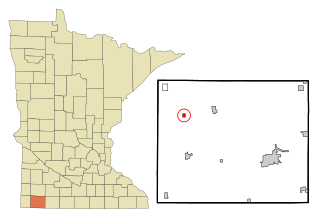
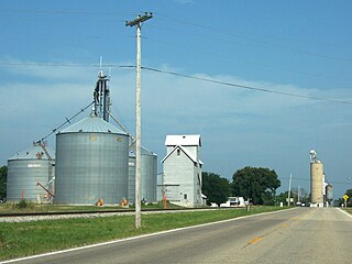
Lismore is a city in Nobles County, Minnesota, United States. The population was 227 at the 2010 census.

<span class="mw-page-title-main">Lyman, Mississippi</span> Census-designated place in Mississippi, United States

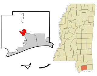
Lyman is a census-designated place (CDP) in Harrison County, Mississippi, United States. It is part of the Gulfport–Biloxi Metropolitan Statistical Area. The population was 1,277 at the 2010 census.

<span class="mw-page-title-main">Landen, Ohio</span> CDP in Ohio, United States

Landen is a census-designated place (CDP) in Deerfield Township, Warren County, Ohio, United States. The population was 6,995 at the 2020 census. It is located around Columbia Road and Montgomery Road in the southeastern part of the township. It surrounds Twenty Mile Stand and near Fosters.

<span class="mw-page-title-main">Mountain Top, Pennsylvania</span> Census-designated place in Pennsylvania, United States

Mountain Top is an unincorporated area and census-designated place (CDP) in Luzerne County, Pennsylvania, United States. As of the 2010 census, its population was 10,982.

<span class="mw-page-title-main">Pine Township, Lycoming County, Pennsylvania</span> Township in Pennsylvania, United States

Pine Township is a township in Lycoming County, Pennsylvania, United States. The population was 260 at the 2020 census, down from 294 in 2010. It is part of the Williamsport Metropolitan Statistical Area.

<span class="mw-page-title-main">Bolivar, Pennsylvania</span> Borough in Pennsylvania, United States

Bolivar is a borough in Westmoreland County, Pennsylvania, United States. The population was 436 at the 2020 census.

<span class="mw-page-title-main">Ojibwa, Wisconsin</span> Town in Wisconsin, United States

Ojibwa is a town in Sawyer County, Wisconsin, United States. The population was 267 at the 2000 census. The unincorporated community of Ojibwa is located in the town.

<span class="mw-page-title-main">Eleva, Wisconsin</span> Village in Wisconsin, United States

Eleva is a village within the Town of Albion in Trempealeau County, Wisconsin, along the Buffalo River. The population was 670 at the 2010 Census and reached 685 in the 2020 Census.

<span class="mw-page-title-main">Genoa City, Wisconsin</span> Village in Wisconsin, United States

Genoa City is a village located in Kenosha and Walworth counties in the U.S. state of Wisconsin, 43 mi (69 km) south-southwest of Milwaukee, located on the Illinois–Wisconsin border. The population was 2,982 at the 2020 census. It was named after Genoa, New York, which was named after Genoa in Italy.

<span class="mw-page-title-main">Genoa Township, DeKalb County, Illinois</span> Township in Illinois, United States

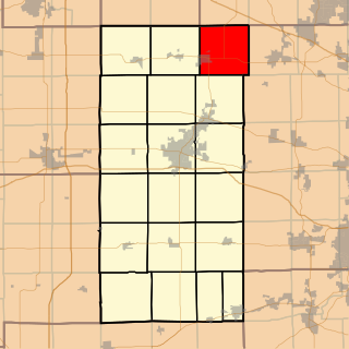
Genoa Township is one of nineteen townships in DeKalb County, USA. At the 2020 census, its population was 5,527 and it contained 2,166 housing units.

<span class="mw-page-title-main">Kingston Township, DeKalb County, Illinois</span> Township in Illinois, United States

Kingston Township is one of nineteen townships in DeKalb County, Illinois, USA. As of the 2020 census, its population was 3,492 and it contained 1,315 housing units.

References

  1. "2020 U.S. Gazetteer Files". United States Census Bureau. Retrieved March 15, 2022.
  2. "G001 - Geographic Identifiers - 2010 Census Summary File 1". United States Census Bureau. Archived from the original on February 13, 2020. Retrieved August 4, 2015.
  3. "Census of Population and Housing". Census.gov. Retrieved June 4, 2015.
  4. "Explore Census Data". data.census.gov. Retrieved June 28, 2022.