Hinesburg, Vermont

Last updated

Hinesburg, Vermont
Town Hall Hinesburg Vermont USA.jpg
Hinesburg town hall
Chittenden County Vermont incorporated and unincorporated areas Hinesburg highlighted.svg
Location in Chittenden County and the state of Vermont.
Usa edcp location map.svg
Red pog.svg
Hinesburg, Vermont
Location in the United States
Coordinates: 44°19′43″N73°6′36″W / 44.32861°N 73.11000°W / 44.32861; -73.11000
Country United States
State Vermont
County Chittenden
Communities Hinesburg
Mechanicsville
Rhode Island Corner
South Hinesburg
Area
  Total39.8 sq mi (103.2 km2)
  Land39.4 sq mi (102.1 km2)
  Water0.4 sq mi (1.0 km2)
Elevation
554 ft (169 m)
Population
 (2020)
  Total4,698
  Density119/sq mi (46.0/km2)
Time zone UTC-5 (Eastern (EST))
  Summer (DST) UTC-4 (EDT)
ZIP code
05461
Area code 802
FIPS code 50-33475 [1]
GNIS feature ID1462119 [2]
Website www.hinesburg.org

Hinesburg is a town in Chittenden County, Vermont, United States. The town was named for Abel Hine, town clerk. [3] The population was 4,698 at the 2020 census. [4]

Contents

The main settlement of Hinesburg in the center of town is a census-designated place (CDP), with a population of 872 at the 2020 census. [5]

Geography

Hinesburg is located in southern Chittenden County, bordered by Addison County to the south. According to the United States Census Bureau, the town has a total area of 39.8 square miles (103.2 km2), of which 39.4 square miles (102.1 km2) is land and 0.39 square miles (1.0 km2), or 1.00%, is water. [6]

The main settlement of Hinesburg is located near the geographic center of town along Vermont Route 116 in the valley of the La Platte River. VT 116 leads north 11 miles (18 km) to South Burlington and south 17 miles (27 km) to Bristol.

Schools and libraries

Champlain Valley Union High School CVU Hinesburg Vermont USA.jpg
Champlain Valley Union High School

Notable events

In April 1985, 29 teachers at Hinesburg Elementary School went on strike for two weeks following a salary dispute. The strike was described by The New York Times as "the longest, most bitter teachers' strike in Vermont history". [7]

On the night of September 29, 2008, the Saputo cheese factory caught fire. [8] The fire department billed the local Saputo cheese plant $500,000 for firefighting gear ruined in fighting the fire. Their destruction was caused by hazardous cleaning chemicals stored at the plant. [9] It was announced in October that the cheese factory would be closed. The factory was the town's third largest employer. [10]

Demographics

Historical population
CensusPop.Note
1790 454
1800 933105.5%
1810 1,23832.7%
1820 1,3327.6%
1830 1,66925.3%
1840 1,6820.8%
1850 1,8349.0%
1860 1,702−7.2%
1870 1,573−7.6%
1880 1,330−15.4%
1890 1,205−9.4%
1900 1,2160.9%
1910 1,042−14.3%
1920 964−7.5%
1930 1,0195.7%
1940 1,000−1.9%
1950 1,12012.0%
1960 1,1805.4%
1970 1,77550.4%
1980 2,69051.5%
1990 3,78040.5%
2000 4,34014.8%
2010 4,3961.3%
2020 4,6986.9%
U.S. Decennial Census [11]

As of the census [1] of 2000, there were 4,340 people, 1,596 households, and 1,174 families residing in the town. The population density was 109.0 people per square mile (42.1/km2). There were 1,693 housing units at an average density of 42.5 per square mile (16.4/km2). The racial makeup of the town was 97.90% White, 0.14% African American, 0.21% Native American, 0.51% Asian, 0.02% Pacific Islander, 0.16% from other races, and 1.06% from two or more races. Hispanic or Latino of any race were 0.78% of the population.

There were 1,596 households, out of which 40.8% had children under the age of 18 living with them, 61.8% were couples living together and joined in either marriage or civil union, 6.9% had a female householder with no husband present, and 26.4% were non-families. 17.0% of all households were made up of individuals, and 4.3% had someone living alone who was 65 years of age or older. The average household size was 2.72 and the average family size was 3.09.

In the town, the population was spread out, with 28.9% under the age of 18, 5.8% from 18 to 24, 36.5% from 25 to 44, 23.4% from 45 to 64, and 5.5% who were 65 years of age or older. The median age was 35 years. For every 100 females, there were 99.4 males. For every 100 females age 18 and over, there were 95.4 males.

The median income for a household in the town was $49,788, and the median income for a family was $54,836. Males had a median income of $40,000 versus $24,107 for females. The per capita income for the town was $22,230. About 2.3% of families and 3.5% of the population were below the poverty line, including 4.4% of those under age 18 and 3.5% of those age 65 or over.

Notable people

Related Research Articles

<span class="mw-page-title-main">Chittenden County, Vermont</span> County in Vermont, United States

Chittenden County is the most populous county in the U.S. state of Vermont. As of the 2020 census, its population was 168,323. The county seat is Vermont's most populous municipality, the city of Burlington. The county has over a quarter of Vermont's population and more than twice the population of Vermont's second-most populous county, Rutland. The county also has more than twice the population density of Vermont's second-most dense county, Washington. The county is named for Vermont's first governor and one of the framers of its constitution as an independent republic and later U.S. state, Thomas Chittenden.

<span class="mw-page-title-main">Monkton, Vermont</span> Town in Vermont, United States

Monkton, also known as Monkton Boro, is a town in Addison County, Vermont, United States. The population was 2,079 at the 2020 census.

<span class="mw-page-title-main">Starksboro, Vermont</span> Town in Vermont, United States

Starksboro is a town in Addison County, Vermont, United States. The population was 1,756 at the 2020 census.

<span class="mw-page-title-main">Charlotte, Vermont</span> Town in Vermont, United States

Charlotte is a town in Chittenden County, Vermont, United States. The town was named for Queen Charlotte, though unlike Charlotte, North Carolina, Charlottesville, Virginia, and other cities and towns that bear her name, the town's name is pronounced with the accent on the second syllable. The population of the town was 3,912 at the 2020 census.

<span class="mw-page-title-main">Colchester, Vermont</span> Town in Vermont, United States

Colchester is a town in Chittenden County, Vermont, United States. As of the 2020 census, the population of Colchester was 17,524. It is the third-most populous municipality and most populous town in the state of Vermont. Colchester borders Burlington, Vermont's most populous municipality. The town is directly to Burlington's north on the eastern shore of Lake Champlain, to the west of the Green Mountains. The Vermont National Guard is based in the town, and it is also home to Saint Michael's College and the Vermont campus of Southern New Hampshire University.

<span class="mw-page-title-main">Huntington, Vermont</span> Town in Vermont, United States

Huntington is a town in Chittenden County, Vermont, United States. The population was 1,938 at the 2020 census.

<span class="mw-page-title-main">Richmond, Vermont</span> Town in Vermont, United States

Richmond is a town in Chittenden County, Vermont, United States. As of the 2020 census the population was 4,167. The main settlement of Richmond, in the north-central part of town, is a census-designated place (CDP), with a population of 853 at the 2020 census; it was formerly an incorporated village.

<span class="mw-page-title-main">Shelburne, Vermont</span> Town in Vermont, United States

Shelburne is a town in Chittenden County, Vermont, United States. Located along the shores of Lake Champlain, Shelburne's town center lies approximately 7 miles (11 km) south of the city center of Burlington, the largest city in the state of Vermont. As of the 2020 census, the population of Shelburne was 7,717.

<span class="mw-page-title-main">St. George, Vermont</span> Town in Vermont, United States

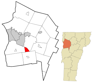
St. George is a town in Chittenden County, Vermont, United States. The town was named for the patron saint of England. St. George has the smallest land area of any town in Vermont, though the incorporated cities of St. Albans, Vergennes, and Winooski are smaller. The population was 794 at the 2020 census.

<span class="mw-page-title-main">Underhill, Vermont</span> Town in Vermont, United States

Underhill is a town in Chittenden County, Vermont, United States. The population was 3,129 at the 2020 census.

<span class="mw-page-title-main">Westford, Vermont</span> Town in Vermont, United States

Westford is a town in Chittenden County, Vermont, United States. The population was 2,062 at the 2020 census.

<span class="mw-page-title-main">Williston, Vermont</span> Town in Vermont, United States

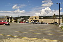
Williston is a town in Chittenden County, Vermont, United States. Originally rural and laid out with many farms, in recent decades it has developed into a thriving suburb of Burlington, the largest city in the state of Vermont. As of the 2020 census, the population of Williston was 10,103, an increase of over 1,000 people since the 2010 census. Williston is one of the fastest-growing towns in Vermont, and while becoming more populated, it has also developed as a major retail center for the Burlington area as well as much of central and northern Vermont. The town contains the village of Williston, which is unincorporated.

<span class="mw-page-title-main">Fairfax, Vermont</span> Town in Vermont, United States

Fairfax is a town in Franklin County, Vermont, United States. The population was 5,014 at the 2020 census.

<span class="mw-page-title-main">Georgia, Vermont</span> Town in Vermont, United States

Georgia is a town in Franklin County, Vermont, United States. The population was 4,845 at the 2020 census.

<span class="mw-page-title-main">Fairlee, Vermont</span> Town in Vermont, United States

Fairlee is a town in Orange County, Vermont, United States. The population was 988 at the 2020 census. It includes the village of Ely. Fairlee is home to Lake Morey, which claims to have the longest ice skating trail in the United States.

<span class="mw-page-title-main">Chittenden, Vermont</span> Town in Vermont, United States

Chittenden is a town in Rutland County, Vermont, United States. The population was 1,237 at the 2020 census.

<span class="mw-page-title-main">Hartford, Vermont</span> Town in Vermont, United States

Hartford is a town in Windsor County, Vermont, United States. It is on the New Hampshire border, at the intersection of Interstates 89 and 91. It is the site of the confluence of the White and Connecticut rivers; the Ottauquechee River also flows through the town. The town is composed of five unincorporated villages: Hartford, Quechee, West Hartford, White River Junction and Wilder. As of the 2020 census, the population was 10,686.

<span class="mw-page-title-main">Jericho (village), Vermont</span> Village in Vermont, United States

Jericho is a village in Chittenden County, Vermont, United States. The population was 1,333 at the 2020 census.

<span class="mw-page-title-main">Jericho, Vermont</span> Town in Vermont, United States

Jericho is a town in Chittenden County, Vermont, United States. As of the 2020 census, the population was 5,104. The town was named after the ancient city of Jericho.

<span class="mw-page-title-main">Milton (CDP), Vermont</span> Census-designated place in Vermont, United States

Milton is an unincorporated village within the town of Milton in Chittenden County, Vermont, United States. The village disincorporated in 2003 and became a census-designated place (CDP) in 2008. As of the 2020 census the population was 3,804, out of a population of 10,723 for the entire town.

References

  1. 1 2 "U.S. Census website". United States Census Bureau . Retrieved January 31, 2008.
  2. "US Board on Geographic Names". United States Geological Survey. October 25, 2007. Retrieved January 31, 2008.
  3. "Census - Geography Profile: Hinesburg town, Chittenden County, Vermont" . Retrieved December 30, 2021.
  4. "Census - Geography Profile: Hinesburg town, Chittenden County, Vermont". United States Census Bureau . Retrieved December 30, 2021.
  5. "Census - Geography Profile: Hinesburg CDP, Vermont". United States Census Bureau . Retrieved December 30, 2021.
  6. "Geographic Identifiers: 2010 Census Summary File 1 (G001): Hinesburg town, Chittenden County, Vermont". U.S. Census Bureau, American Factfinder. Archived from the original on February 13, 2020. Retrieved August 19, 2015.
  7. "Teacher Strike Splits Vermont Town". The New York Times. June 30, 1985. Retrieved August 24, 2018.
  8. "Saputo fire under investigation". The Sun. Retrieved October 6, 2008.
  9. Baird, Joel Banner (October 24, 2008). Fire department bills Saputo $500,000. Burlington Free Press.
  10. "Burlington Free Press" . Retrieved October 24, 2008.
  11. "U.S. Decennial Census". United States Census Bureau. Retrieved May 16, 2015.
  12. Guest, James A. (1979). Vermont Legislative Directory (1979). Montpelier, VT: Vermont Secretary of State. p. 131.
  13. Marquis Who's Who Staff (2000). Who Was Who In America. Chicago, IL: Marquis Who's Who. p. 131. ISBN   9780837902326.