History of Saint Martin (island)

Last updated

St. Martin's history shares many commonalities with other Caribbean islands. Its earliest inhabitants were Amerindians, followed by Europeans who brought slavery to exploit commercial interests.

Contents

Early history

Ancient relics date the island's first settlers, probably Ciboney Indians (a subgroup of Arawaks), back to 3,500 years ago.[ citation needed ] Then another group of Arawaks migrated from South America's Orinoco basin around 800 A.D.[ citation needed ] Because of St. Martin's salt-pans they called it "Soualiga," or "Land of Salt." Mainly a farming and fishing society, the Arawaks lived in villages of straw-roofed buildings which were strong enough to resist hurricanes. Their tranquil civilization valued artistic and spiritual pursuits.[ citation needed ]

Their lives were turned upside-down, however, with the descent of the Carib Indians from the same region they had come from. A warrior nation, the Caribs killed the Arawak men and enslaved the women. When Europeans began to explore the Caribbean, Carib society had almost completely displaced the Arawaks.[ citation needed ]

Colonial Era

In 1493, on Christopher Columbus second voyages to the West Indies, upon first sighting the island he named it Isla de San Martín after Saint Martin of Tours because it was November 11, St. Martin Day.[ citation needed ] However, though he claimed it as a Spanish territory, Columbus never landed there, and Spain made the settlement of the island a low priority.

The French and Dutch, on the other hand, both coveted the island. While the French wanted to colonize the islands between Trinidad and Bermuda, the Dutch found San Martín a convenient halfway point between their colonies in New Amsterdam (present day New York) and Brazil. With few people inhabiting the island, the Dutch easily founded a settlement there in 1631, erecting Fort Amsterdam as protection from invaders. Jan Claeszen Van Campen became its first governor, and soon thereafter the Dutch West India Company began their salt mining operations. French and British settlements sprang up on the island as well. Taking note of these successful colonies and wanting to maintain their control of the salt trade, the Spanish now found St. Martin much more appealing. The Eighty Years' War which had been raging between Spain and the Netherlands provided further incentive to attack.

Spanish forces captured Saint Martin from the Dutch in 1633, seizing control and driving most or all of the colonists off the island. At Point Blanche, they built Old Spanish Fort to secure the territory. Although the Dutch retaliated in several attempts to win back St. Martin, they failed. Fifteen years after the Spanish conquered the island, the Eighty Years' War ended. Since they no longer needed a base in the Caribbean and St. Martin barely turned a profit, the Spanish lost their inclination to continue defending it. In 1648, they deserted the island.

With St. Martin free again, both the Dutch and the French jumped at the chance to re-establish their settlements. Dutch colonists came from St. Eustatius, while the French came from St. Kitts. After some initial conflict, both sides realized that neither would yield easily. Preferring to avoid an all-out war, they signed the Treaty of Concordia in 1648, which divided the island in two. The treaty was signed by the two governors of the island, Robert de Longvilliers for France and Martin Thomas for the States General of the Netherlands. The French would keep the north area they occupied and the coast facing Anguilla, while the Dutch would have the area of the fort and the land around it on the south coast. The inhabitants would share the natural resources of the island. [1]

A legend grew up around the division of the island. According to legend, in order to decide on their territorial boundaries, the two sides held a contest. It began with a Frenchman drinking wine and a Dutchman drinking jenever (Dutch gin). When both had sufficiently imbibed, they embarked from Oysterpond on the island's east coast. The Frenchman headed off along the coast to the north, while the Dutchman followed the coast south; wherever the two groups met was where they would draw the dividing line from Oysterpond. But as the Dutchman met a woman and stopped to sleep off the effects of the gin, the Frenchman was able to cover more distance, but apparently also cheated as he cut through the northeastern part of the island, and therefore ended up with more land.

Though oft-repeated, the story is not historically accurate. During the treaty's negotiation, the French had a fleet of naval ships off shore, which they used as a threat to bargain more land for themselves. In spite of the treaty, relations between the two sides were not always cordial. Between 1648 and 1816, conflicts changed the border sixteen times. In the end, the French came out ahead with 21 square miles (54 km2) to the 16 square miles (41 km2) of the Dutch side.

In 1651, the Compagnie des Îles de l'Amérique sold the French part of the island to the Order of Saint John which was sovereign over Malta, at the time a vassal state of the Kingdom of Sicily. The Order's rule lasted for fourteen years, and in 1665 it was sold back to the French West India Company along with the Order's other possessions in the Caribbean.

Although the Spanish had been the first to import slaves to the island, their numbers had been few. But with the new cultivation of cotton, tobacco, and sugar, mass numbers of slaves were imported to work on the plantations. The slave population quickly grew larger than that of the land owners. Subjected to cruel treatment, slaves staged rebellions, and their overwhelming numbers made them impossible to ignore. In 1848, the French abolished slavery in their colonies including the French side of St. Martin. Slaves on the Dutch side of the island protested and threatened to flee to the French side to seek asylum. The local Dutch authorities relented and emancipated the colonies' slaves. While this decree was respected locally, it was not until 1863 when the Dutch abolished slavery in all of their island colonies that the slaves became legally free. [2]

20th century and beyond

After abolition of slavery, plantation culture declined and the island's economy suffered. In 1939, St. Martin received a major boost when it was declared a duty-free port. The Dutch began focusing on tourism in the 1950s. It took the French another twenty years to start developing their tourism industry. Currently, tourism provides the backbone of the economy for both sides of the island. [3]

On September 5, 1995, Hurricane Luis severely pounded the islands causing numerous damages 35 years to the day after Hurricane Donna.

In 1994, the Kingdom of the Netherlands and France signed the Franco-Dutch treaty on Saint Martin border controls, which allows for joint Franco-Dutch border controls on so-called "risk flights". After some delay, the treaty was ratified in November 2006 in the Netherlands, and subsequently entered into force on 1 August 2007. Though the treaty is now in force, its provisions are not yet implemented as the working group specified in the treaty is not yet installed.

On September 6, 2017, Hurricane Irma, a Category 5+ storm with sustained winds of over 180 MPH, devastated the island, leaving severe damage. The Netherlands and France created different funds to restore the economy of the island. The Netherlands made available a fund of over 550 million euros which was managed by a recovery planning bureau also known are the NRPB. [4]

See also

Related Research Articles

<span class="mw-page-title-main">Netherlands Antilles</span> 1954–2010 Caribbean constituent country of the Netherlands

The Netherlands Antilles ; Papiamento: Antia Hulandes) was a constituent country of the Kingdom of the Netherlands. The country consisted of several island territories located in the Caribbean Sea. The islands were also informally known as the Dutch Antilles. The country came into being in 1954 as the autonomous successor of the Dutch colony of Curaçao and Dependencies. The Antilles were dissolved in 2010. The Dutch colony of Surinam, although it was relatively close by on the continent of South America, did not become part of the Netherlands Antilles but became a separate autonomous country in 1954. All the island territories that belonged to the Netherlands Antilles remain part of the kingdom today, although the legal status of each differs. As a group they are still commonly called the Dutch Caribbean, regardless of their legal status. People from this former territory continue to be called Antilleans in the Netherlands.

<span class="mw-page-title-main">History of Saint Kitts and Nevis</span> Aspect of history

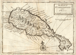
Saint Kitts and Nevis have one of the longest written histories in the Caribbean, both islands being among Spain's and England's first colonies in the archipelago. Despite being only two miles apart and quite diminutive in size, Saint Kitts and Nevis were widely recognized as being separate entities with distinct identities until they were forcibly united in the late 19th century.

<span class="mw-page-title-main">History of Saint Lucia</span> Aspect of history

Saint Lucia was inhabited by the Arawak and Kalinago Caribs before European contact in the early 16th century. It was colonized by the British and French in the 17th century and was the subject of several possession changes until 1814, when it was ceded to the British by France for the final time. In 1958, St. Lucia joined the short-lived semi-autonomous West Indies Federation. Saint Lucia was an associated state of the United Kingdom from 1967 to 1979 and then gained full independence on February 22, 1979.

<span class="mw-page-title-main">History of Saint Vincent and the Grenadines</span> Aspect of history

The indigineous inhabitants of the islands of St. Vincent and the Grenadines were various Amerindian groups. The arrivals of Europeans in the early 16th century did not lead to long term settlement, only in 1717 did the French occupy the island in Barrouallie, though the English laid claim on St. Vincent in 1627. The Treaty of Paris (1763) saw St. Vincent ceded to Britain. Frictions with the British led to the First and Second Carib War in the mid- to late-18th century but the British held on to the islands. A Crown Colony government was installed in 1877, a Legislative Council created in 1925, and universal adult suffrage granted in 1951. Following a referendum in 1979, St. Vincent and the Grenadines became the last of the Windward Islands to gain independence on 27 October 1979.

<span class="mw-page-title-main">Saint Martin (island)</span> Small island in the Caribbean

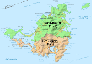
Saint Martin is an island in the northeast Caribbean, approximately 300 km (190 mi) east of Puerto Rico. The 87 square kilometres (34 sq mi) island is divided roughly 60:40 between the French Republic and the Kingdom of the Netherlands, but the Dutch part is more populated than the French part. The division dates to 1648. The northern French part comprises the Collectivity of Saint Martin and is an overseas collectivity of the French Republic. As part of France, the French part of the island is also part of the European Union. The southern Dutch part comprises Sint Maarten and is one of four constituent countries that form the Kingdom of the Netherlands.

This is a page on the history of the island of Martinique.

<span class="mw-page-title-main">Leeward Islands</span> Subgroup of islands in the West Indies

The Leeward Islands are a group of islands situated where the northeastern Caribbean Sea meets the western Atlantic Ocean. Starting with the Virgin Islands east of Puerto Rico, they extend southeast to Guadeloupe and its dependencies. In English, the term Leeward Islands refers to the northern islands of the Lesser Antilles chain. The more southerly part of this chain, starting with Dominica, is called the Windward Islands. Dominica was originally considered a part of the Leeward Islands, but was transferred from the British Leeward Islands to the British Windward Islands in 1940.

<span class="mw-page-title-main">Sint Eustatius</span> Special municipality of the Netherlands

Sint Eustatius ), known locally as Statia, is an island in the Caribbean. It is a special municipality of the Netherlands.

<span class="mw-page-title-main">SSS islands</span> Group of islands in the Caribbean Sea

The SSS islands, locally also known as the Windward Islands, is a collective term for the three territories of the Dutch Caribbean that are located within the Leeward Islands group of the Lesser Antilles. In order of population size, they are: Sint Maarten, Sint Eustatius and Saba. In some contexts, the term is also used to refer to the entire island of Saint Martin, alongside Sint Eustatius and Saba.

<span class="mw-page-title-main">The Guianas</span> Region in north-central South America

The Guianas, sometimes called by the Spanish loan-word Guayanas, is a region in north-eastern South America which includes the following three territories:

The Treaty of Concordia, or the Partition Treaty of 1648, was signed on March 23, 1648, between the Kingdom of France and the Dutch Republic and divided the island of Saint Martin.

<span class="mw-page-title-main">Collectivity of Saint Martin</span> French overseas collectivity, part of the island of Saint Martin in the Lesser Antilles

The Collectivity of Saint Martin, commonly known as simply Saint Martin, is an overseas collectivity of France in the West Indies in the Caribbean, on the northern half of the island of Saint Martin, as well as some smaller adjacent islands. Saint Martin is separated from the island of Anguilla by the Anguilla Channel. Its capital is Marigot.

<span class="mw-page-title-main">Sint Maarten</span> Country on the Caribbean island of Saint Martin, part of the Kingdom of the Netherlands

Sint Maarten ) is a constituent country of the Kingdom of the Netherlands in the Caribbean. With a population of 41,486 as of January 2019 on an area of 34 km2 (13 sq mi), it encompasses the southern 44% of the divided island of Saint Martin, while the northern 56% of the island constitutes the French overseas collectivity of Saint Martin. Sint Maarten's capital is Philipsburg. Collectively, Sint Maarten and the other Dutch islands in the Caribbean are often called the Dutch Caribbean.

<span class="mw-page-title-main">Flag of Sint Maarten</span>

The flag of Sint Maarten consists of a white triangle situated at the hoist charged with the constituent country's coat of arms, along with two horizontal bands of red and blue. Adopted in 1985 shortly after the territory was granted a coat of arms, it has been the flag of Sint Maarten since 13 June of that year. Since the dissolution of the Netherlands Antilles on 10 October 2010, it has been the sole flag used in the constituent country.

<span class="mw-page-title-main">Caribbean</span> Region to the east of Central America

The Caribbean is a subregion of the Americas that includes the Caribbean Sea and its islands, some of which are surrounded by the Caribbean Sea and some of which border both the Caribbean Sea and the North Atlantic Ocean; the nearby coastal areas on the mainland are often also included in the region. The region is southeast of the Gulf of Mexico and the North American mainland, east of Central America, and north of South America.

<span class="mw-page-title-main">Languages of the Caribbean</span> Languages of the region

The languages of the Caribbean reflect the region's diverse history and culture. There are six official languages spoken in the Caribbean:

<span class="mw-page-title-main">Economy of Saint Martin (island)</span>

The economy of Saint Martin, divided between the French Collectivity of Saint Martin and the Dutch Sint Maarten, is predominately dependent on tourism. For more than two centuries, the main commodity exports have generally been salt and locally grown commodities, like sugar.

<span class="mw-page-title-main">Afro-Vincentians</span>

Afro-Vincentians or Black Vincentians are Vincentians whose ancestry lies within Sub-Saharan Africa.

<span class="mw-page-title-main">Saint Martin–Sint Maarten border</span> International border

The Saint Martin–Sint Maarten border, or France–Netherlands border, is the border between the Collectivity of Saint Martin, an overseas collectivity of France, and Sint Maarten, a constituent country of the Kingdom of the Netherlands, on the island of Saint Martin in the Caribbean. The 87-square-kilometre (34 sq mi) island is divided roughly 60:40 between the French Republic and the Kingdom of the Netherlands by the 16 km (10 mi) border, however the two parts are roughly equal in population.

<span class="mw-page-title-main">Unification of Saint Martin</span> Unification of the Caribbean island of Saint Martin

The unification of Saint Martin is the proposed unification of the small island of Saint Martin, located in the Caribbean Sea. Currently, it is divided into Sint Maarten and the Collectivity of Saint Martin. The island has been divided since the signing of the Treaty of Concordia in 1648, which today remains as one of the oldest treaties still in effect.

References

  1. Henocq, Christophe (15 March 2010), "Concordia Treaty, 23rd March 1648", Heritage, 6: 13, retrieved 2018-09-17
  2. Lampe, Armando (2001). Mission Or Submission?: Moravian and Catholic Missionaries in the Dutch Caribbean During the 19th Century. Otto Harrassowitz Verlag. p. 154. ISBN   9783525559635.
  3. St. Maarten: Bits of history". St. Maarten Tourism Office.
  4. "Hurricane Irma kills eight on Caribbean island of Saint Martin". Reuters. Retrieved 7 September 2017.