Related Research Articles

Geographically, Iran is located in West Asia and borders the Caspian Sea, Persian Gulf, and Gulf of Oman. Its mountains have impacted both the political and the economic history of the country for several centuries. The mountains enclose several broad basins, on which major agricultural and urban settlements are located. Until the 20th century, when major highways and railroads were constructed through the mountains to connect the population centers, these basins tended to be relatively isolated from one another.

Iran has a long paved road system linking most of its towns and all of its cities. In 2011 the country had 173,000 kilometres (107,000 mi) of roads, of which 73% were paved. In 2008 there were nearly 100 passenger cars for every 1,000 inhabitants.

Bandar-e Anzali is a city of Gilan Province, Iran. At the 2011 census, its population was 144,664.
The Trans-Asian Railway(TAR) is a project to create an integrated freight railway network across Europe and Asia. The project is of the United Nations Economic and Social Commission for Asia and the Pacific (UNESCAP).

Ahvaz is a city in the southwest of Iran and the capital of Khuzestan province. Ahvaz's population is about 1,300,000 and its built-up area with the nearby town of Sheybani is home to 1,136,989 inhabitants. It is home to Persians, Arabs, Bakhtiaris, Dezfulis, Shushtaris, and others. Languages spoken in the area include Persian and Arabic, as well as dialects of Luri (Bakhtiari), Dezfuli, Shushtari, and others.

The Eurasian Land Bridge, sometimes called the New Silk Road, is the rail transport route for moving freight and passengers overland between Pacific seaports in the Russian Far East and China and seaports in Europe. The route, a transcontinental railroad and rail land bridge, currently comprises the Trans-Siberian Railway, which runs through Russia and is sometimes called the Northern East-West Corridor, and the New Eurasian Land Bridge or Second Eurasian Continental Bridge, running through China and Kazakhstan. As of November 2007, about one percent of the $600 billion in goods shipped from Asia to Europe each year were delivered by inland transport routes.

Arak is the capital of Markazi Province, Iran. At the 2011 census, its population was 526,182, in 160,761 families. The city is nicknamed the "Industrial Capital of Iran".

The Trans-Iranian Railway was a major railway building project started in Pahlavi Iran in 1927 and completed in 1938, under the direction of the then-Iranian monarch Reza Shah. It was entirely built with indigenous capital, and links the capital Tehran with Bandar Shahpur on the Persian Gulf in the south and Bandar Shah on the Caspian Sea in the north, via Ahvaz and Ghom. In 1961, under Reza Shah's son Mohammad Reza Pahlavi, it was extended from Bandar Shah to a new terminus in Gorgan. During the land reforms of Mohammad Reza Pahlavi in 1963, as part of the "White Revolution", the Trans-Iranian railway was extended to link Tehran to Mashhad, Tabriz and Isfahan.
Caspian Airlines is an airline headquartered in Tehran, Iran. Established in 1993, it operates services between Tehran and other major cities in Iran and international flights to Armenia, Syria, Turkey, United Arab Emirates and Ukraine. Its main base is Mehrabad International Airport, Tehran.
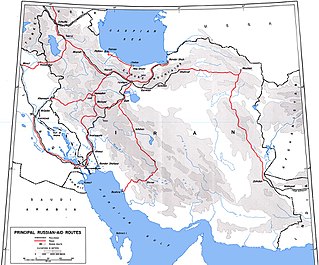
The Persian Corridor was a supply route through Iran into Soviet Azerbaijan by which British aid and American Lend-Lease supplies were transferred to the Soviet Union during World War II. Of the 17.5 million long tons of U.S. Lend-Lease aid provided to the Soviet Union, 7.9 million long tons (45%) were sent through Iran.
Bandar-e Emam Khomeyni is a city and capital of Bandar-e Emam Khomeyni District of Mahshahr County, Khuzestan Province, Iran. As of the 2006 census, its population was 67,078, in 14,681 families.

The Islamic Republic of Iran Navy, officially abbreviated NEDAJA, is the naval warfare service branch of Iran's regular military, the Islamic Republic of Iran Army (Artesh). It is one of Iran's two maritime military branches, alongside the Navy of the Islamic Revolutionary Guard Corps (IRGC).

The Trans-Caspian Railway is a railway that follows the path of the Silk Road through much of western Central Asia. It was built by the Russian Empire during its expansion into Central Asia in the 19th century. The railway was started in 1879, following the Russian victory over Khokand. Originally it served a military purpose of facilitating the Imperial Russian Army in actions against the local resistance to their rule. However, when Lord Curzon visited the railway, he remarked that he considered its significance went beyond local military control and threatened British interests in Asia.

The Islamic Republic of Iran Railways is the national state-owned railway system of Iran. The Raja Passenger Train Company is an associate of the IR, and manages its passenger trains. The Railway Transportation Company is an associate of the IR, which manages its freight transport. The Ministry of Roads & Urban Development is the state agency that oversees the IRIR. Some 33 million tonnes of goods and 29 million passengers are transported annually by the rail transportation network, accounting for 9 percent and 11 percent of all transportation in Iran, respectively (2011).
The New Eurasian Land Bridge, also called the Second or New Eurasian Continental Bridge, is the southern counterpart to the Eurasian Land Bridge and runs through China and Central Asia with possible plans for expansion into South and West Asia. The Eurasian Land Bridge system is important as an overland rail link between China and Europe, with transit between the two via Central Asia and Russia.

The International North–South Transport Corridor (INSTC) is a 7,200-km-long multi-mode network of ship, rail, and road route for moving freight between India, Iran, Azerbaijan, Russia, Central Asia and Europe. The route primarily involves moving freight from India, Iran, Azerbaijan and Russia via ship, rail and road. The objective of the corridor is to increase trade connectivity between major cities such as Mumbai, Moscow, Tehran, Baku, Bandar Abbas, Astrakhan, Bandar Anzali, etc. Dry runs of two routes were conducted in 2014, the first was Mumbai to Baku via Bandar Abbas and the second was Mumbai to Astrakhan via Bandar Abbas, Tehran and Bandar Anzali. The objective of the study was to identify and address key bottlenecks. The results showed transport costs were reduced by "$2,500 per 15 tons of cargo". Other routes under consideration include via Kazakhstan and Turkmenistan.

The Anglo-Soviet invasion of Iran or Anglo-Soviet invasion of Persia was the joint invasion of the neutral Imperial State of Iran by the United Kingdom and the Soviet Union in August 1941. The invasion, code name Operation Countenance, was largely unopposed by the numerically and technologically outmatched Iranian forces. The multi-pronged coordinated invasion took place along Iran's borders with the Kingdom of Iraq, Azerbaijan SSR, and Turkmen SSR, with fighting beginning on 25 August and ending on 31 August when the Iranian government formally agreed to surrender, having already agreed to a ceasefire on 30 August.

Turkmenistan has 4,980 kilometres (3,090 mi) of railways. The railway operator is the state owned company Türkmendemirýollary. The company belongs to the Ministry of Railways of Turkmenistan. Turkmenistan is currently expanding its rail system to cover 5,256.25 kilometres (3,266.08 mi) more distance, which will take its network to 10,236.25 kilometres (6,360.51 mi) track kilometres by 2025.
Arme Construction Company has been one of Iran's and the Middle East's largest construction companies.
The 4th Region or the Northern Fleet is the flotilla of the Islamic Republic of Iran Navy in the Caspian Sea.
References
- ↑ Pinkepank, Jerry A. The Second Diesel Spotter's Guide 1973 Kalmbach Books p.233
- ↑ DeNevi & Hall United States Military Railway Service (1992) Boston Mills Press ISBN 1-55046-021-8 pp.8&73-77
- ↑ "ЖДМ 03-2003: Железнодорожное строительство в Иране". Archived from the original on 2011-11-13. Retrieved 2013-09-25.