Nursling is a village in the civil parish of Nursling and Rownhams, in the Test Valley district, in Hampshire, England, about 6 kilometres north-west of the city of Southampton. Formerly called Nhutscelle, then Nutsall, Nutshalling or Nutshullyng until the mid-19th century, it has now been absorbed into the suburbs of Southampton, although it is not part of the district of Southampton.

Burnham is a large village and civil parish that lies north of the River Thames in Buckinghamshire, between the towns of Maidenhead and Slough, about 24 miles west of Charing Cross, London. It is probably best known for the nearby Burnham Beeches woodland.
Taplow is a village and civil parish in the Unitary Authority of Buckinghamshire, England. It sits on the left bank of the River Thames, facing Maidenhead in the neighbouring county of Berkshire, with Cippenham and Burnham to the east. It is the south-westernmost settlement in Buckinghamshire.

Willen is a district of Milton Keynes, England and is also one of the ancient villages of Buckinghamshire to have been included in the designated area of the New City in 1967. The original village is now a small but important part of the larger district that contains it and to which it gives its name. It is in the civil parish of Campbell Park.

Haughton-le-Skerne is a village in the borough of Darlington in the ceremonial county of Durham, England. It is situated in the north east of Darlington. The village lies to the west of the River Skerne. At the centre of the village green, is the main road towards Darlington town centre going across the river, south of the church. There used to be a linen mill on the riverbank on the east side of the village. Part of the mill leat can still be seen today.
Eton Rural District was a rural district in the administrative county of Buckinghamshire, England, covering an area in the south-east of the county. It was named after but did not contain Eton, which was an urban district.

Denton is a small village in the civil parish of Newhaven, in the Lewes district, in the county of East Sussex, England. It adjoins the villages of South Heighton and Mount Pleasant and backs onto the South Downs.

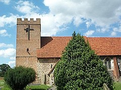
North Charford is a hamlet in the civil parish of Breamore, in the New Forest district, in Hampshire, England, near the Wiltshire border. Historically the name refers to a manor which is on the west bank of the River Avon.
Ousefleet is a small hamlet and former civil parish, now in the parish of Twin Rivers, in the East Riding of Yorkshire, England approximately 5 miles (8 km) east of Goole. It is located just south of the River Ouse and north of the A161 road between Goole and Scunthorpe. In 1961 the parish had a population of 167.

East Marden is a village and former civil parish, now in the parish of Marden, in the Chichester district of West Sussex, England. It is on the spur of the South Downs It is first mentioned in the Domesday Book as Meredone and was given in 1086 to Roger, Earl of Montgomery. The church, St Peters, dates from the 12th century and is still used for worship every other Sunday. Its oldest house today dates back to 1728. The village, some 100 metres above sea level, is in an area of unusually high rainfall. Its most famous landmark is the thatched well on the village green. The population has remained static for over a century. In 1931 the parish had a population of 80. On 1 April 1933 the parish was abolished to form "Marden".

Swalecliffe is a part of the ribbon development of the north Kent coast between Whitstable and Herne Bay in Southeast England. It forms Swalecliffe ward of City of Canterbury Council.

Almer is a village and former civil parish, now in the parish of Sturminster Marshall, in the Dorset district, in the ceremonial county of Dorset, England. Almer is located on the A31 road near Winterborne Zelston, Huish Manor, Sturminster Marshall and opposite the Drax estate. The main features of the village are Almer Manor, Almer Parish church and the old school house. The school was co-educational; it opened in 1925 and closed in 1964. The Almer School Honours tablet is now kept in Winterborne Zelston village hall. The seven residential properties in Almer are owned and let by the Charborough (Drax) Estate. In 1931 the parish had a population of 108. On 1 April 1933 the parish was abolished and merged with Sturminster Marshall.

Barford St Michael is a village and former civil parish, now in the parish of Barford St. John and St. Michael, in the Cherwell district, in the county of Oxfordshire, England. It is on the south bank of the River Swere, about 5 miles (8 km) south of Banbury.

Merston is a small village, an Anglican parish and former civil parish, now in the civil parish of Oving, in the Chichester district of West Sussex, England. It lies just south of the A259 road 2.4 miles (3.9 km) southeast of Chichester.

Stroxton is a village in the civil parish of Little Ponton and Stroxton, in the South Kesteven district of Lincolnshire, England. It is situated 3 miles (4.8 km) south from the centre of Grantham and about 1 mile (1.6 km) north-west from Great Ponton and the A1 road.

Froxfield Green is a village in the civil parish of Froxfield and Privett, in the East Hampshire district of Hampshire, England. It is 3 miles (5 km) north-west of Petersfield, and lies just north of the A272 road.

Creeksea is a village and former civil parish, now in the parish of Burnham-on-Crouch, in the Maldon district, in the county of Essex, England. It is on the Dengie peninsula on the north side of the River Crouch, one mile west of Burnham-on-Crouch. In 1931 the parish had a population of 76.

Ousden is a village and civil parish in the West Suffolk district of Suffolk in eastern England. It is located around 6 miles (10 km) west of Bury St Edmunds and 72 miles (116 km) north of London, and as of 2011, its population is 266. The village has an Anglican church of St Peter's and a chapel in the cemetery dedicated to St Barnabas.
West Huntspill is a settlement and civil parish about 5 miles from Bridgwater, in the county of Somerset, England. The parish includes the village of Huntspill and the hamlet of Alstone. In 2011 the parish had a population of 1414. The parish touches Burnham-on-Sea and Highbridge, East Huntspill, Otterhampton, Pawlett and Puriton.

The Borough of Slough is a unitary authority with borough status in the ceremonial county of Berkshire, Southern England. The borough is centred around the town of Slough and includes Langley. It forms an urban area with parts of Buckinghamshire and extends to the villages of Burnham, Farnham Royal, George Green, and Iver. Part of the district's area was in Buckinghamshire prior to the district's formation and in Middlesex until 1965.