Deblois is a town in Washington County, Maine, United States. The town was named after T.A. Deblois, president of the Bank of Portland. The population was 74 at the 2020 census.

South Browning is a census-designated place (CDP) in Glacier County, Montana, United States. The population was 1,785 at the 2010 census. South Browning is a rural village on the Blackfeet Indian Reservation. It is bordered to the north by the town of Browning.
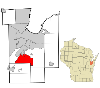
Rockland is a town in Brown County in the U.S. state of Wisconsin. The population was 1,734 at the 2010 census.

Poynette is a village in Columbia County, Wisconsin, United States. The population was 2,575 at the 2022 United States census. It is part of the Madison Metropolitan Statistical Area.
Hollandale is a village in Iowa County, Wisconsin, United States. The population was 306 at the 2020 census. It is part of the Madison Metropolitan Statistical Area.

Curran is a town in Jackson County, Wisconsin, United States. The population was 343 at the 2010 census.

Bay City is a village on the Mississippi River in Pierce County, Wisconsin, United States. The population was 500 at the 2010 census.

Footville is a village in Rock County, Wisconsin, United States. The population was 772 at the 2020 census.

Weyerhaeuser is a village in Rusk County, Wisconsin, United States. The population was 238 at the 2010 census.

Readstown is a village in Vernon County, Wisconsin, United States. The population was 376 at the 2020 census.

Dousman is a village in Waukesha County, Wisconsin, United States. The population was 2,419 at the 2020 census.
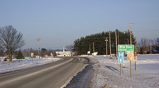
Wild Rose is a village in Waushara County, Wisconsin, United States. The population was 725 at the 2010 census.

Milladore is a village in Wood County and overlapping into Portage County in the U.S. state of Wisconsin. The population was 276 at the 2010 census. Most of the village is located within the Town of Milladore in Wood County, while only a very small portion of the village lies in Portage County. All of its 2010 census population resided in the Wood County portion of the village.

Lowell is a village in Dodge County, Wisconsin, United States, along the Beaver Dam River. The population was 340 at the 2010 census. The village is located within the Town of Lowell.

Highland is a village in Iowa County, Wisconsin, United States. The population was 842 at the 2010 census. It is part of the Madison Metropolitan Statistical Area. The village is located within the Town of Highland.

Ridgeway is a town in Iowa County, Wisconsin, United States. The population was 563 at the 2020 census. The Village of Ridgeway is located within the town. The unincorporated community of Hyde is also located in the town.

Hixton is a town in Jackson County, Wisconsin, United States. The population was 611 at the 2000 census. The Village of Hixton is located within the town. The unincorporated community of Sechlerville is also located in the town.

Casco is a village in Kewaunee County, Wisconsin, United States. The population was 583 at the 2010 census. It is part of the Green Bay Metropolitan Statistical Area. The village is located within the Town of Casco. Casco is named after Casco Bay on the coast of Maine, the previous home of Edward Decker, an early logger in Kewaunee County.
Belmont is a village in Lafayette County, Wisconsin, United States. The population was 989 at the 2020 census. It was the original capital of the Wisconsin Territory during the first legislative assembly in 1836.

Spencer is a village in Marathon County, Wisconsin. It is part of the Wausau, Wisconsin Metropolitan Statistical Area. The population was 1,925 at the 2010 census.


