
Spearfishing is a method of fishing that involves impaling the fish with a straight pointed object such as a spear, gig or harpoon. It has been deployed in artisanal fishing throughout the world for millennia. Early civilisations were familiar with the custom of spearing fish from rivers and streams using sharpened sticks.
The three islands of the Cayman Islands are the exposed top of an underwater mountain. Underwater, the sides of this mountain are quite steep, vertical in some places, within as little as a few hundred metres from shore.
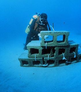
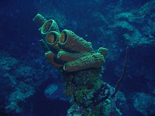
An artificial reef is a human-created underwater structure, typically built to promote marine life in areas with a generally featureless bottom, to control erosion, block ship passage, block the use of trawling nets, or improve surfing.

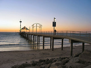
Glenelg is a beach-side suburb of the South Australian capital of Adelaide. Located on the shore of Holdfast Bay in Gulf St Vincent, it has become a tourist destination due to its beach and many attractions, home to several hotels and dozens of restaurants.
Brighton is a coastal suburb of Adelaide, South Australia, situated between Seacliff and Glenelg and aside Holdfast Bay. Some notable features of the area are the Brighton-Seacliff Yacht Club, the Brighton Surf Lifesaving Club, the Brighton Jetty, and a beach. The Windsor Theatre constructed in 1925 is a long-standing institution, showing cinema to the locals usually two films per night.

Edithburgh is a small town on the south-east corner of Yorke Peninsula situated on the coastline of Salt Creek Bay, in the state of South Australia. Edithburgh is about 50 km (31 mi) west of Adelaide across Gulf St Vincent, but 226 km (140 mi) away by road. At the 2016 census, the locality had a population of 516 of which 454 lived in its town centre.

Port Noarlunga is a suburb in the City of Onkaparinga, South Australia. It is a small sea-side suburb, population 2,918, about 30 kilometres to the south of the Adelaide city centre and was originally created as a sea port. This area is now popular as a holiday destination or for permanent residents wishing to commute to Adelaide or work locally. There is a jetty that connects to a 1.6 kilometres long natural reef that is exposed at low tide. The beach is large and very long and has reasonable surfing in the South Port area whose name is taken from its location - "South of the Port".
Mabul is a small island off the south-eastern coast of Sabah in Malaysia. The island has been a fishing village since the 1970s. In the 1990s, it first became popular to divers due to its proximity to Sipadan island.
Seacliff is a coastal suburb located in the capital city of South Australia; Adelaide. Overseen by the council, City of Holdfast Bay, this suburb is adjacent to South Brighton, Seacliff Park, Marino and Kingston Park.
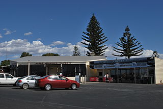
Port Hughes is a town and locality in the Australian state of South Australia located on northern Yorke Peninsula about 135 kilometres (84 mi) north-west of the state capital of Adelaide. It is considered part of the Moonta urban area by the Australian Bureau of Statistics. At the 2016 census, Port Hughes had a population of 571.

Wool Bay is a locality and a former government town in the Australian state of South Australia on the east coast of southern Yorke Peninsula. It is located between Stansbury and Coobowie on Yorke Peninsula, approximately 220 kilometres from Adelaide by road, but only just over 60 km due west across Gulf St Vincent.
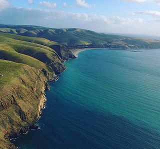
Rapid Bay is a locality that includes a small seaside town and bay on the west coast of the Fleurieu Peninsula, South Australia. It lies within the District Council of Yankalilla and its township is approximately 100 km south of the state capital, Adelaide. A pair of jetties are popular attractions for recreational fishing, scuba diving and snorkelling. The bay particularly known as a site for observing leafy seadragons in the wild. Its postcode is 5204.

The Portsea Hole is a depression in the seafloor of Port Phillip near Portsea in Victoria, Australia. The undefined area of the depression, generally assessed at 10 hectares, is one of six separate areas that comprise the Port Phillip Heads Marine National Park and is a popular site for divers.

Sodwana Bay is a bay in South Africa on the KwaZulu Natal north coast, between St. Lucia and Lake Sibhayi. It is in the Sodwana Bay National Park, and the Maputaland Marine Reserve, and is a popular recreational diving destination. The term is commonly used to refer to both the marine reserve and the terrestrial park, as well as the geographical bay.

The Patawalonga River is a river located in the western suburbs of the Adelaide metropolitan area, in the Australian state of South Australia. It drains an area of flat, swampy lands formerly known as the Cowandilla Plains or The Reedbeds, which in the mid-20th century were drained by engineering works, enabling the establishment of Adelaide Airport and the development of residential housing.
Neville Coleman OAM was an Australian naturalist, underwater nature photographer, writer, publisher and educator.
The Cave Divers Association of Australia (CDAA) is a cave diving organisation which was formed in September 1973 to represent the interests of recreational scuba divers who dive in water‐filled caves and sinkholes principally in the Lower South East of South Australia (SA) and secondly in other parts of Australia. Its formation occurred after a series of diving fatalities in waterfilled caves and sinkholes in the Mount Gambier region between 1969 and 1973 and in parallel to a South Australian Government inquiry into these deaths. The CDAA's major achievement has been the dramatic reduction of fatalities via the introduction of a site rating scheme and an associated testing system which was brought in during the mid-1970s. While its major area of operation is in the Limestone Coast region of SA, it administers and supports cave diving activity in other parts of Australia including the Nullarbor Plain and Wellington, New South Wales.

Recreational dive sites are specific places that recreational scuba divers go to enjoy the underwater environment or for training purposes. They include technical diving sites beyond the range generally accepted for recreational diving. In this context all diving done for recreational purposes is included. Professional diving tends to be done where the job is, and with the exception of diver training and leading groups of recreational divers, does not generally occur at specific sites chosen for their easy access, pleasant conditions or interesting features.
The Society for Underwater Historical Research (SUHR) was an amateur maritime archaeology organisation operating in South Australia (SA). It was formed in 1974 by recreational scuba divers and other persons to pursue an interest in maritime archaeology and maritime history. The SUHR was renamed as the South Australian Archaeology Society in March 2012 as part of a plan to expand its activities beyond maritime archaeology to include other archaeological disciplines.

As of 2014, there have been 82 recorded shark attacks in South Australia since the establishment of the colony in 1836. 20 of those have involved a single fatality. Victims were involved in a range of aquatic activities, including surfing, diving, spear-fishing, snorkeling, boating and swimming. Six of the fatalities occurred off the coast of greater metropolitan Adelaide, with the remainder distributed across South Australia's extensive coastline. Many of the fatal attacks have been attributed to Great white sharks.

