Smoky Bay, South Australia

Last updated

Smoky Bay
South Australia
Smoky Bay Jetty, 2017 (01).jpg
Smoky Bay Jetty, 2017
Australia South Australia location map.svg
Red pog.svg
Smoky Bay
Coordinates 32°22′36″S133°56′12″E / 32.376536°S 133.936627°E / -32.376536; 133.936627 Coordinates: 32°22′36″S133°56′12″E / 32.376536°S 133.936627°E / -32.376536; 133.936627 [1]
Population
Established13 November 1913 (town)
28 January 1999 (locality) [4] [5]
Postcode(s) 5680
Elevation1 m (3 ft)
Time zone ACST (UTC+9:30)
 • Summer (DST) ACST (UTC+10:30)
LGA(s) District Council of Ceduna [1]
Region Eyre Western [1]
County Way [1]
State electorate(s) Flinders [6]
Federal division(s) Grey [7]
Localities around Smoky Bay:
Laura Bay Mudamuckla
Puntabie
Carawa
Smoky Bay (body of water)
Great Australian Bight
Smoky Bay Carawa
Haslam
Great Australian Bight Great Australian Bight Streaky Bay (body of water)
FootnotesAdjoining localities [1]

Smoky Bay (formerly Wallanippie) is a town and locality located in the Australian state of South Australia on the west coast of the Eyre Peninsula. Previously used as a port, the town is now a residential settlement and popular tourist destination known for its recreational fishing, with a boat ramp and jetty located in the town.

Contents

At the 2016 census, the locality of Smoky Bay had a population of 279 of which 217 lived in the town of Smoky Bay. [3] [2]

History

European discovery and settlement

Smoky Bay's coastline was first sighted and mapped by the British navigator, Matthew Flinders, in 1802, who named it "Smoky Bay" after the amount of smoke from fires lit by the area's Aboriginal people. [8]

Whalers were the first Europeans to inhabit the coastline near the current site of the town, just north of Pt. Collinson. Recently, dune erosion has uncovered parts of the ruins of their camps, with pieces of whale bone and three one-hundred gallon cooking pots discovered. [9] The historic Port Collinson Whaling Station remnants are listed on the South Australian Heritage Register. [10]

In the early 1860s pastoralists arrived in the district. Former Adelaide civil servant Charles Francis Heath (1832–83) established a sheep grazing property which he named Wallanippie Station after the Aboriginal name of a waterhole near his homestead at the back of Point Brown promontory.

A feud took place in 1865 between two Aboriginal men at Wallanippie Station, resulting in one being speared and the other charged with murder. [11] Heath was required to attend the Supreme Court in Adelaide as a witness. The trial was notable in that it was an instance of British law intervening in traditional Aboriginal law.

Following that the government decided that the developing district needed established law and order. On 16 November 1865, Heath was appointed the first justice of the peace and local magistrate for Smoky Bay. [12] After nearly ten years on Eyre Peninsula, Heath returned to Adelaide and rejoined the civil service.

Establishment of the government town

In the early 1900s the town area was opened up, with the first building a tin hut erected in 1905. Scrubcutters cleared the area by 1906, and by 1911 a post office, repeating station and living quarters had been built. The town continued to grow, with a school and hall opened in 1909. A jetty was proposed for erection in 1908, and finally completed in 1913. [9]

The town of Smoky Bay was surveyed in 1913 under the name of Wallanippie, along with the aforementioned jetty and a Harbour's Board reserve. A large galvanised iron goods shed and a railway line extending to the far end of the jetty were established, allowing the town to operate as a port.

The town's original name of "Wallanippie" was officially changed to "Smoky Bay" in 1940, after continued use of this name by locals since the town's establishment. [13] The town became less important throughout the mid-1900s, and its capacity as a port was diminished, leaving the town as a residential, as well as an agricultural centre for the surrounding community. [9]

The growing of oysters was established in the bay in 1988, providing a new economic facet for the town, and adding to the town's promise as a tourist destination. [14]

During the 2002/2003 summer, a ban on taking all shellfish from the waters of the bay was imposed after a deadly biotoxin was discovered in the shellfish. [15]

Geography

The town of Smoky Bay lies on the bay of the same name, north of Streaky Bay. The bay is shielded from ocean swells by a small promenade of land that leads to Point Brown. Around 10 km offshore lies "Eyre Island", a small, sandy island that also protects the bay. [16]

Offshore lie a number of small, granitic islands which are home to many seabirds and tiger snakes that feed on the birds. The Nuyts Archipelago lies to the west, the islands of which are not easily accessible.

Inside the bay, the calm waters are dominated by shallow stretches of seagrass, sandflats, mudflats, as well as numerous channels or "creeks" that allow boat access, with slightly deeper water. [17]

Surrounding the bay is a mixture of mangroves to the south and coastal sand dune vegetation to the north. The mangroves tend to give the water in some parts of the bay a yellow stain, presumed to be from tannins and decaying leaf matter.

The town itself is situated on a long, sandy beach that ends at the boat ramp. Inland is dominated by agricultural land, used for cropping and grazing of sheep.

The bay is home to a large variety of seabirds, as well as many fish species, including great white sharks, which are frequent visitors from the offshore islands. Seals also enter the bay, providing further incentive for sharks to enter the bay. [18]

Economy

The town has long since ceased function as a port, but since 1988 has experienced a surge in the aquaculture of oysters. The initial area allocation was of 85 ha within Smoky Bay, with individual farms having a maximum size of 10 ha. This has since been increased to 165 ha (including 40 ha of subtidal or deepwater culture). Smoky Bay oysters are well recognized within South Australia, along with other producers such as Coffin Bay. [14]

Tourism has been a rapidly expanding sector of the town's economy, with a caravan park and numerous beach side shacks established. Recreational fishing is the largest draw to the town, with the jetty and boat ramp heavily used in the summer holidays. Other water based sports such as swimming and snorkelling are popular, with a large shark proof cage constructed on the side of the jetty. Swimming outside of this enclosure can be risky, as evident by a recent death[ when? ] caused by a large shark in the bay. [18]

The local oyster industry has been the source of tourist attractions also, with guided tours now established.[ citation needed ]

Community

The town has around 200 permanent residents, with that number swelling to around 1000 in the peak summer months. The small town has a very basic general store and petrol and diesel are occasionally available. [19]

There is a sporting club north of the caravan park with an oval and tennis courts. The club serves meals and is open to the general public. [20]

There is a single church, of the Uniting denomination opposite the caravan park. The town has a recently constructed boat ramp with a fee payable to Ceduna Council for its use.[ when? ] The old jetty, which has been shortened due to storm damage still stands, with the remnants of the original structure still standing off the end of the jetty.[ citation needed ]

Marilyns Country Music Festival is a unique annual event held in Smoky Bay, It is the only music event in the world using an Oyster Barge as a stage, Held in September this event attracts artists and patrons from all over Australia.[ citation needed ]

Transport

Smoky Bay is accessed from the Flinders Highway, which runs along the coast of the Peninsula. Stateliner bus services also run buses to the town, with the town's station located opposite the general store. [21]

The Streaky Bay and Ceduna airfields also offer flights to the area, however another form of transport must be found to get down to Smoky Bay.

Related Research Articles

Port Lincoln City in South Australia

Port Lincoln is a town on the Lower Eyre Peninsula in the Australian state of South Australia. It is situated on the shore of Boston Bay, which opens eastward into Spencer Gulf. It is the largest city in the West Coast region, and is located approximately 280 km as the crow flies from the State's capital city of Adelaide. In June 2019 Port Lincoln had an estimated population of 16,418, having grown at an average annual rate of 0.55% year-on-year over the preceding five years. The city is reputed to have the most millionaires per capita in Australia, as well as claiming to be Australia's "Seafood Capital".

Ceduna, South Australia Town in South Australia

Ceduna is a town in South Australia located on the shores of Murat Bay on the west coast of Eyre Peninsula. It lies west of the junction of the Flinders and Eyre Highways around 786 km northwest of the capital Adelaide. The port town/suburb of Thevenard lies 3 km to the west on Cape Thevenard. It is in the District Council of Ceduna, the federal Division of Grey, and the state electoral district of Flinders.

Flinders Highway, South Australia

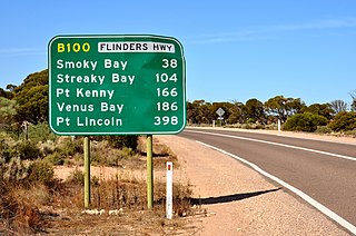
Flinders Highway connects the South Australian towns of Ceduna and Port Lincoln, a distance of 396 kilometres, and is currently signed as B100. Flinders Highway - along with Lincoln Highway - presents an alternative but somewhat longer coastal route between Ceduna and Port Augusta, compared to the more direct route along Eyre Highway.

The Eyre Peninsula is a triangular peninsula in South Australia. It is bounded by the Spencer Gulf on the east, by the Great Australian Bight on the west, and by the Gawler Ranges on the north.

Thevenard, South Australia Town in South Australia

Thevenard is a port town 3 kilometres (1.9 mi) south-west of Ceduna, South Australia. It is named after nearby Cape Thevenard, which in turn had been named after Antoine-Jean-Marie Thévenard, a French admiral. At the 2006 census, Thevenard had a population of 776.

Arno Bay is a small fishing and tourist town on the east coast of Eyre Peninsula in South Australia, located on the Lincoln Highway about halfway between Whyalla and Port Lincoln. First proclaimed under the name Bligh in 1883, the current name dates back to 1940. It is a recreational town with a number of marine and nature based attractions, including fishing, surfing and swimming.

Tumby Bay, South Australia Town in South Australia

Tumby Bay is a coastal town situated on the Spencer Gulf, on the eastern coast of Eyre Peninsula in South Australia, 45 kilometres (28 mi) north of Port Lincoln. The town of Tumby Bay is the major population centre of the District Council of Tumby Bay, and the centre of an agricultural district farming cereal crops and sheep, as well as having established fishing and tourism industries.

Elliston, South Australia Town in South Australia

Elliston is a small coastal town in the Australian state of South Australia on the west coast of Eyre Peninsula 169 km northwest of Port Lincoln and 641 km west of Adelaide. The township is located on Waterloo Bay. At the 2006 census, Elliston had a population of 377.

Port Neill, South Australia Town in South Australia

Port Neill is a small coastal town on the eastern side of the Eyre Peninsula, in South Australia about 3 km off the Lincoln Highway between the major towns of Whyalla and Port Lincoln. It is 576 km by road from Adelaide.

Cowell, South Australia Town in South Australia

Cowell is a coastal town on Franklin Harbor on the eastern side of the Eyre Peninsula, in South Australia on the Lincoln Highway 111 km south of the major town of Whyalla. It is 493 km by road from Adelaide.

District Council of Franklin Harbour Local government area in South Australia

The District Council of Franklin Harbour is a local government area in South Australia on the Eyre Peninsula. Cowell is the major population centre of an agricultural district based on farming wheat and sheep, supplemented by a fishing and oyster farming industries. The district's coastal towns including Cowell and Lucky Bay attract large numbers of tourists during school holidays, with the new Spencer Gulf ferry service increasing traffic to these areas since 2006.

Streaky Bay, South Australia Town in South Australia

Streaky Bay is a coastal town on the western side of the Eyre Peninsula, in South Australia just off the Flinders Highway, 303 km (188 mi) north-west of Port Lincoln and 727 km (452 mi) by road from Adelaide. At the 2016 census, Streaky Bay recorded a population of 1, 378.

District Council of Ceduna Local government area in South Australia

The District Council of Ceduna is a local government area located on the far west coast of the Eyre Peninsula in South Australia. The district has a diverse business and industry with an estimated 240,000 tourists passing through every year. The township of Ceduna is the focal point of the district.

Denial Bay is a town and an associated locality in the Australian state of South Australia located on the state's west coast about 562 kilometres (349 mi) north-west of the state capital of Adelaide and about 10 kilometres (6.2 mi) west of the municipal seat of Ceduna. The town which is located on the western side of Murat Bay has extensive European history, first built on in 1889, and now hosts a large expanse of oyster farms, one of the largest on the Eyre Peninsula.

Penong, South Australia Town in South Australia

Penong is a town and locality on the Nullarbor Plain, in the far west of the state of South Australia located about 616 kilometres (383 mi) north-west of the state capital of Adelaide. With no settlements between it and Border Village on the border with Western Australia, 400 km (250 mi) away on the Eyre Highway, it is a popular rest-stop for travellers.

St Peter Island (South Australia) Island in South Australia

St Peter Island is an island in the Nuyts Archipelago on the west coast of Eyre Peninsula in South Australia near Ceduna. It is the second largest island in South Australia and about 13 km (8.1 mi) long. It was one of the first parts of South Australia to be discovered and named by Europeans, along with St Francis Island, mapped by François Thijssen in 't Gulden Zeepaert in 1627.

Louth Bay is a town and locality in the Australian state of South Australia. It is named after the bay named by Matthew Flinders on 26 February 1802 which itself is derived from a place in Lincolnshire. At the 2006 census, Louth Bay had a population of 408.

Laura Bay is a locality in the Australian state of South Australia located on the west coast of the Eyre Peninsula overlooking the Great Australian Bight about 533 kilometres north-west of the Adelaide city centre and about 19 kilometres south east of the town centre of Ceduna.

Laura Bay is a bay in the Australian state of South Australia on the west coast of Eyre Peninsula located about 15 kilometres (9.3 mi) southeast of Ceduna.

Charra is a locality in the Australian state of South Australia located on the state’s west coast overlooking the Great Australian Bight about 584 kilometres north-west of the state capital of Adelaide and about 33 kilometres west of the municipal seat of Ceduna.

References

Notes
  1. For the 2016 census, the 'Urban Centre and Locality of Smoky Bay' consisted of the area gazetted as the government town of Smoky Bay. [2] [1]
  2. For the 2016 census, the 'State Suburb of Smoky Bay' consisted of the locality of Smoky Bay and following islands from the Nuyts Archipelago – Eyre Island and the Franklin Islands. [3] [1]
Citations
  1. 1 2 3 4 5 6 7 "Search results for 'Smoky Bay, LOCB' with the following datasets being selected – 'NPW and Conservation Properties'. 'Suburbs and Localities', 'Counties', 'Government Towns', 'Local Government Areas','Postcodes', 'SA Government Regions', 'Gazetteer' and 'Roads'". Location SA Map Viewer. Government of South Australia. Retrieved 4 June 2018.
  2. 1 2 3 Australian Bureau of Statistics (27 June 2017). "Smoky Bay (urban centre)". 2016 Census QuickStats. Retrieved 4 June 2018. OOjs UI icon edit-ltr-progressive.svg
  3. 1 2 3 Australian Bureau of Statistics (27 June 2017). "Smoky Bay (state suburb)". 2016 Census QuickStats. Retrieved 4 June 2018. OOjs UI icon edit-ltr-progressive.svg
  4. Bice, John G. (13 November 1913). "TOWN OF WALLANIPPIE" (PDF). The South Australian Government Gazette. South Australian Government. pp. 1296–1287. Retrieved 4 June 2018.
  5. Kentish, P.M. (28 January 1999). "GEOGRAPHICAL NAMES ACT 1991 Notice to Assign Boundaries and Names to Places (in the District Council of Ceduna)" (PDF). The South Australian Government Gazette. South Australian Government. p. 610. Retrieved 4 June 2018.
  6. "District of Flinders". Electoral Commission SA. Retrieved 29 May 2018.
  7. "Federal electoral division of Grey". Australian Electoral Commission. Retrieved 29 May 2018.
  8. State Library of South Australia, Smoky Bay , retrieved 12 June 2007
  9. 1 2 3 Ceduna Tourism, Smoky Bay, archived from the original on 31 August 2007, retrieved 12 June 2007
  10. "Point Collinson Whaling Station Site". South Australian Heritage Register. Department of Environment, Water and Natural Resources. Retrieved 13 February 2016.[ permanent dead link ]
  11. Advertiser, 17 August 1865, page 3.
  12. S.A. Government Gazette, 16 November 1865.
  13. "Names of towns decided by popular usage". Port Lincoln Times: 3. 26 September 1940. Retrieved 7 April 2016.
  14. 1 2 Oysterfest Site, History, archived from the original on 12 September 2007, retrieved 25 May 2007
  15. Primary Industries and Resources, Smoky Bay Closure, archived from the original on 20 September 2006, retrieved 12 June 2007
  16. SA waterways, Smoky Bay, archived from the original on 6 July 2007, retrieved 25 May 2007
  17. Maps of Estuaries, Smoky Bay, archived from the original on 29 September 2007, retrieved 25 May 2007
  18. 1 2 Emma Pedler, ABC, Fatal Shark Attack at Smoky Bay, Australian Broadcasting Corporation, archived from the original on 29 May 2006, retrieved 25 May 2007
  19. Nullabor.net, Smoky Bay , retrieved 25 May 2007
  20. DC of Ceduna, Smoky Bay, archived from the original on 16 February 2007, retrieved 25 May 2007
  21. Premier Stateliner, Eyre Peninsula Stateliner Bus Service, archived from the original on 9 December 2006, retrieved 12 June 2007