The Investigator Group is an archipelago in South Australia that consists of Flinders Island and five island groups located off the western coast of the Eyre Peninsula. It is named after HMS Investigator by her commander, Matthew Flinders when he explored the area in 1802. The Group lies within the Great Australian Bight. All the islands except Flinders Island, and a part of Pearson Island, are within the Investigator Group Wilderness Protection Area and the Waldegrave Islands Conservation Park.

Cape Spencer is a headland in the Australian state of South Australia located on the south west tip of Yorke Peninsula in the gazetted locality of Inneston. It was named after George Spencer, 2nd Earl Spencer by Matthew Flinders during March 1802. It has been the site of an operating navigation aid since 1950 and has been located within the Innes National Park since 1970.

The Backstairs Passage is a strait in South Australia lying between Fleurieu Peninsula on the Australian mainland and Dudley Peninsula on the eastern end of Kangaroo Island. The western edge of the passage is a line from Cape Jervis on Fleurieu Peninsula to Kangaroo Head on Kangaroo Island. The Pages, a group of islets, lie in the eastern entrance to the strait. About 14 km wide at its narrowest, it was formed by the rising sea around 13,000 years ago, at the end of the Pleistocene era, when it submerged the land connecting what is now Kangaroo Island with the Fleurieu Peninsula. Backstairs Passage was named by Matthew Flinders whilst he and his crew on HMS Investigator were exploring and mapping the coastline of South Australia in 1802.
Williams Island is an island in the Australian state of South Australia located off the south coast of Jussieu Peninsula on Eyre Peninsula approximately 34 km (21 mi) south-east of Port Lincoln. It was named by Matthew Flinders for Robert Williams who subsequently lost his life along with seven other crew in the capsize of a cutter launched from HM Sloop Investigator to search for water on 21 February 1802. Since 2004, the island has been part of the Memory Cove Wilderness Protection Area.
Little Island is an island in the Australian state of South Australia located in Spencer Gulf off the east coast of Jussieu Peninsula on Eyre Peninsula approximately 28 kilometres (17 mi) south-east of Port Lincoln. It was named by Matthew Flinders in memory of John Little who was one of the eight crew lost from a cutter that capsized sometime after being launched from HM Sloop Investigator to search for water on 21 February 1802. Since 2004, the island has been part of the Memory Cove Wilderness Protection Area.
Smith Island is an island located in Spencer Gulf off the east coast of Jussieu Peninsula on Eyre Peninsula in South Australia approximately 32 km (20 mi) south-east of Port Lincoln. It was named by Matthew Flinders in memory of William Smith who was one of the eight crew lost from a cutter that capsized sometime after being launched from HM Sloop Investigator to search for water on 21 February 1802. Since 2004, the island has been part of the Memory Cove Wilderness Protection Area.
Lewis Island is an island located in Spencer Gulf off the east coast of Jussieu Peninsula on Eyre Peninsula in South Australia approximately 29 km (18 mi) south-east of Port Lincoln. It was named by Matthew Flinders in memory of George Lewis who was one of the eight crew lost from a cutter that capsized sometime after being launched from HM Sloop Investigator to search for water on 21 February 1802. Since 2004, the island has been part of the Memory Cove Wilderness Protection Area.

Anxious Bay is a bay in the Australian state of South Australia located on the west coast of Eyre Peninsula about 275 kilometres west north-west of Adelaide. It was named by Matthew Flinders on 21 February 1802. It is one of four ‘historic bays’ located on the South Australian coast.

Pondalowie Bay is a bay in the Australian state of South Australia located on the west coast of the south-west tip of Yorke Peninsula in Spencer Gulf about 12 kilometres west of Marion Bay. The coastline of Pondalowie Bay is both within the gazetted locality of Inneston and the Innes National Park.
Cape Donington is a headland in the Australian state of South Australia located at the most northerly part of the Jussieu Peninsula on the east coast of Eyre Peninsula in about 10 kilometres east of the city of Port Lincoln.
Ward Islands is an island group in the Australian state of South Australia located in the Investigator Group about 53 kilometres west by south of Cape Finniss on the west coast of Eyre Peninsula. The group was discovered and named by Matthew Flinders on 13 February 1802. The island group has enjoyed protected area status since the 1960s and since 2011, it been part of the Investigator Group Wilderness Protection Area.
Topgallant Islands is an island group in the Australian state of South Australia located in the Investigator Group about 22 kilometres south west of Cape Finniss on the west coast of Eyre Peninsula. The group was discovered and named by Matthew Flinders on 13 February 1802. The island group has enjoyed protected area status since the 1960s and since 2011, it has been part of the Investigator Group Wilderness Protection Area.

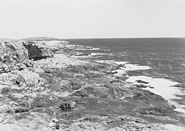
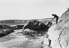
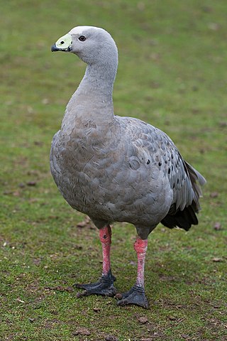
Waldegrave Islands is an island group in the Australian state of South Australia located in the Investigator Group about 2.5 kilometres northwest by west of Cape Finniss on the west coast of Eyre Peninsula. The group consists of Waldegrave Island, Little Waldegrave Island and according to some sources, a pair of rocks known as the Watchers. The group is notable as a breeding site for Australian sea lions and Cape Barren geese. The group has enjoyed protected area status since the 1960s and as of 1972 has been part of the Waldegrave Islands Conservation Park.
Cape Wiles is a headland located on the west side of the southern tip of Eyre Peninsula in South Australia about 27 kilometres south west of the city of Port Lincoln. The cape is described by one source as being the south east extremity of “a broad promontory” of which Cape Carnot is the south west extremity at a distance of 3 nautical miles to the west. The cape also is the western extremity of Sleaford Bay.
Cape Radstock is a headland located on the west coast of Eyre Peninsula in South Australia about 45 kilometres south south-east of the town of Streaky Bay and about 9.3 kilometres (5 nmi) south east of Point Labatt. The cape is both the north western extremity of Anxious Bay and the southern extremity of the Calca Peninsula. The cape is described as being “steep and bold” and where the cliffs reach a height of 135 metres, being the high point of a line of cliffs starting at Point Labatt in the west and from within Anxious Bay in the east. It was named by Matthew Flinders on 9 February 1802 after William Waldegrave, 1st Baron Radstock. Since 2012, the waters adjoining its shoreline are within a habitat protection zone in the West Coast Bays Marine Park.
Point Weyland is a headland located on the west coast of Eyre Peninsula in South Australia about 4 kilometres west south-west of the town of Venus Bay and about 51 kilometres north north-west of the town of Elliston. The point which is located within Anxious Bay is the southern extremity of the opening to Venus Bay. The point is described by one source as being "a conspicuous cliffy point, 89 m (292 ft) high, stands close S[outh] W[est] of the entrance of Venus Bay" and "rises to a height of 96 m (315 ft), close N[orth] and slopes inland toward Venus Bay". It was named by Matthew Flinders on 10 February 1802. The point has been within the boundary of the Venus Bay Conservation Park since 1977 while the waters adjoining its shoreline have been within a habitat protection zone in the West Coast Bays Marine Park since 2012.
Slade Point is a headland in the Australian state of South Australia located on the west coast of Eyre Peninsula in the locality of Sceale Bay about 29 kilometres (18 mi) south of the town of Streaky Bay. The point is the northern extremity of Searcy Bay and the southern extremity of a promontory that separates Searcy Bay in the south east from Sceale Bay in the north west. While it is within the coastline first charted by Matthew Flinders on 9 February 1802, it is not named by Flinders possibly due to the coastline being obscured by a thick haze. Slade Point was named in 1908 after “the late Mr. W. E. Slade” who served as the Assistant Engineer of Harbours in the South Australian Government. The cape has adjoined the boundary of the Cape Blanche Conservation Park since 2012 while the waters adjoining its shoreline have been within a habitat protection zone in the West Coast Bays Marine Park also since 2012.
Cape Blanche is a headland located on the west coast of Eyre Peninsula in South Australia about 25 kilometres south south-west of the town of Streaky Bay and about 4 kilometres west of the town of Sceale Bay.
Pearson Isles is an island group located in the Australian state of South Australia about 65 kilometres to 72 kilometres west south-west of Cape Finniss on the west coast of Eyre Peninsula within the larger island group, the Investigator Group. The group was discovered and named by Matthew Flinders on 13 February 1802. The group has four members - Pearson Island, a pair of islands known as the Veteran Isles and Dorothee Island. The island group has enjoyed protected area status starting in 1916 and since 2011, it has been part of the Investigator Group Wilderness Protection Area. The island group is notable as a venue for scientific research.

Sleaford Bay is a bay located in the Australian state of South Australia on the southern coast of Eyre Peninsula. It was named by the British navigator, Matthew Flinders in 1802.