The Spencer Gulf is the westernmost and larger of two large inlets on the southern coast of Australia, in the state of South Australia, facing the Great Australian Bight. It spans from the Cape Catastrophe and Eyre Peninsula in the west to Cape Spencer and Yorke Peninsula in the east.

The Eyre Peninsula is a triangular peninsula in South Australia. It is bounded by the Spencer Gulf on the east, the Great Australian Bight on the west, and the Gawler Ranges to the north.

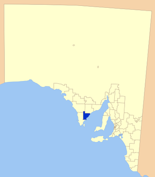
The City of Port Lincoln is a local government area located on the southern tip of the Eyre Peninsula in South Australia. It consists of one suburb - Port Lincoln. It is surrounded on land by the District Council of Lower Eyre Peninsula, which also has offices in Port Lincoln.

The District Council of Lower Eyre Peninsula is a local government area located on Eyre Peninsula in South Australia. The district covers the southern tip of the peninsula, except for the small area taken up by the City of Port Lincoln.
The District Council of Kimba is a local government area located on the northern Eyre Peninsula in South Australia. The district is mostly agricultural in nature, with the township of Kimba being the focal point of the district. With a number of towns positioned close to the Gawler Ranges, the district receives a modest amount of attention from tourists, who also stop by to see Kimba's Big Galah.
Cleve is a small agriculturally based town on Central Eyre Peninsula in South Australia. It is 226 km southwest of Port Augusta and 143 km north of Port Lincoln. At the 2006 census, Cleve had a population of 738. The town has its origins in the 1850s, with the town established some twenty years later.

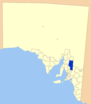
The District Council of Cleve is a local government area on the eastern Eyre Peninsula in South Australia. The district is mostly agricultural in nature, but also encompasses the popular coastal tourist town of Arno Bay.

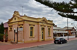
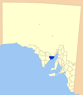
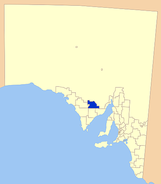
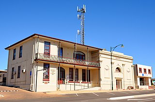
Cowell is a coastal town on Franklin Harbor on the eastern side of the Eyre Peninsula, in South Australia on the Lincoln Highway 111 km south of the major town of Whyalla. It is 493 km by road from Adelaide.
The District Council of Streaky Bay is a local government area in South Australia located on the Eyre Peninsula. Streaky Bay is the main population centre of about 1,200 people serving an agricultural district based on farming wheat and other cereal crops, sheep, supplemented by fishing and tourism industries. The district covers an area of 6,251.1 square kilometres with a population of 2,074 people in 2016, according to the Australian Bureau of Statistics. Mayor of Streaky Bay is Travis Barber.

The District Council of Ceduna is a local government area located on the far west coast of the Eyre Peninsula in South Australia. The district has a diverse business and industry with an estimated 240,000 tourists passing through every year. The township of Ceduna is the focal point of the district.
The Tumby Bay District Council is a local government area of South Australia covering an area of the North Eastern Eyre Peninsula. It was established in 1906, only six years after the town of Tumby Bay was established, when the district was severed from the former District Council of Lincoln to form the present council.

Wudinna District Council is a rural local government area on central Eyre Peninsula, South Australia. Its seat is Wudinna, on the Eyre Highway, 580 kilometres (360 mi) west of Adelaide. The district's economy is largely driven by agriculture, mainly cereal crops, with beef and sheep commonly farmed as well.
The Regional Council of Goyder is a local government area located in the Mid North region of South Australia. The council area is reliant on agriculture as a mainstay of its economy, with manufacturing and tourism also becoming prominent. The council seat lies at Burra, with a branch office situated at Eudunda.
Denial Bay is a town and an associated locality in the Australian state of South Australia located on the state's west coast about 562 kilometres (349 mi) north-west of the state capital of Adelaide and about 10 kilometres (6.2 mi) west of the municipal seat of Ceduna.The town which is located on the western side of Murat Bay has extensive European history, first built on in 1889, and now hosts a large expanse of oyster farms, one of the largest on the Eyre Peninsula.

Lucky Bay is a locality in the District Council of Franklin Harbour, on the Spencer Gulf coast of Eyre Peninsula in South Australia. It is a terminus for SeaSA's Spencer Gulf passenger ferry and a transshipping port for grain export operated by T-Ports. Lucky Bay is located immediately north-east of the Franklin Harbour wetlands. Its adjacent waters lie within the outer boundary of the Franklin Harbor Marine Park. A ferry service crossing Spencer Gulf from Lucky Bay to Wallaroo commenced in 2006, and the dirt road connecting Lucky Bay with the Lincoln Highway was sealed in 2008.
Cowell Area School is an R-12 Government Public school in Cowell, a small coastal town 494 km away from Adelaide, South Australia in the District Council of Franklin Harbour district. The school now has about 190 students, with a capacity of up to 300. The school is highly supported by the local community which works mainly in farming, aquaculture and mining. The school owns an oyster lease and runs a significant Aquaculture Skills Centre.

The County of Jervois is a cadastral unit in the Australian state of South Australia that covers land on the east coast of the Eyre Peninsula. It was proclaimed on 24 January 1878 and named after William Jervois, the Governor of South Australia from October 1877 to January 1883.
Midgee is a locality in the Australian state of South Australia located on the east coast of Eyre Peninsula about 214 kilometres north-west of the state capital of Adelaide and about 37 kilometres north of the municipal seat of Cowell.
Mitchellville is a locality in the Australian state of South Australia located on the east coast of Eyre Peninsula about 198 kilometres north-west of the state capital of Adelaide and about 23 kilometres north of the municipal seat of Cowell.
Port Gibbon is a locality in the Australian state of South Australia located on the east coast of Eyre Peninsula about 208 kilometres north-west of the state capital of Adelaide and about 17 kilometres south-west of the municipal seat in Cowell.