
The Mid Murray Council is a local government area in South Australia in the Murray and Mallee region of South Australia. The council spans the area from the Riverland through the Murraylands to the eastern slopes of the Mount Lofty Ranges. It includes 220 km of the Murray River. The council seat is at Mannum; it also maintains secondary offices at Cambrai and Morgan.
The Murray Mallee is the grain-growing and sheep-farming area of South Australia. It is bounded to the north and west by the Murray River, called the "River Murray" in South Australia, to the east by the Victorian border, and extending about 50 km south of the Mallee Highway.

Berri Barmera Council is a local government area in the Riverland region of South Australia.
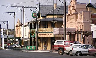
Pinnaroo is a town in the Murray Mallee region of South Australia, near the border with Victoria, 243 km east of Adelaide. Pinnaroo is on the north side of the Mallee Highway, and on the railway line between Tailem Bend and Ouyen. The roadhouse on the highway at Pinnaroo is the first "food and leg-stretch" stop on the bus route from Adelaide to Sydney.
Parilla is a town and a locality in the Australian state of South Australia located in the state's Murray Mallee region about 192 kilometres (119 mi) east of the state capital of Adelaide, about 32 kilometres (20 mi) west of the municipal seat of Pinnaroo and about 14 kilometres (8.7 mi) east of the town of Lameroo.
Lameroo is a town in the Murray Mallee region of South Australia. It is on the Mallee Highway and Pinnaroo railway line about 40 km west of the Victorian border, or 210 km east of Adelaide. It is primarily a service town for the surrounding rural areas, growing grain and sheep. Lameroo now includes the former settlements of Kulkami, Mulpata, Wirha and Gurrai, which were on the Peebinga railway line, and Wilkawatt, which was between Parrakie and Lameroo on the Pinnaroo railway.
Jabuk is a locality in the Australian state of South Australia located about 142 kilometres (88 mi) south-east of the state capital of Adelaide and respectively about 78 kilometres (48 mi) west and 58 kilometres (36 mi) east of the municipal seats of Pinnaroo and Tailem Bend.

The Mallee Football League (MFL) was an Australian rules football competition in South Australia. The league comprised teams located in south eastern South Australia and one team (Murrayville) located in western Victoria.
The Border Times, based in Pinnaroo, is the local newspaper of the Southern Mallee region of South Australia since 1911. Published weekly, it focuses on local news, sports and weather.

Coorong District Council is a local government area in South Australia located between the River Murray and the Limestone Coast region. The district covers mostly rural areas with small townships, as well as part of the Coorong National Park.

The Renmark Paringa Council is a local government area located adjacent to the Victorian border, in the Riverland, South Australia. The area is known for its various fruit production, and is heavily dependent on the River Murray as a water source. The council seat is at Renmark.

Parrakie, South Australia is a small town on the Mallee Highway and Pinnaroo railway line approximately 26 kilometres west of Lameroo. The name is derived from the Aboriginal word perki which means cave or limestone sink hole. The town was surveyed in 1907.
Geranium is a town and locality in the Murray Mallee region of South Australia near the Mallee Highway. At the 2006 census, Geranium had a population of 240. It was surveyed in 1910 as the town supporting a station on the Pinnaroo railway line. The name is derived from a native plant prolific in the area.

The Murraylands is a geographical region of the Australian state of South Australia (SA); its name reflects that of the river running through it. Lying due east of South Australia's capital city, Adelaide, it extends from the eastern slopes of the Mount Lofty Ranges to the border with the state of Victoria, a distance of about 180 kilometres. The north-to-south distance is about 130 kilometres. The region's economy is centred on agriculture, and tourism, especially along its 200-kilometre (120-mile) frontage of the River Murray.
Albert was an electoral district of the House of Assembly in South Australia, spanning its time as both a colony and a state. It was created in 1875, taking much territory from adjacent Victoria, merged with Victoria in 1902 as Victoria and Albert, separated again in 1915, and abolished in 1970.
Browns Well Highway is a road connecting Loxton, South Australia through the Murray Mallee to Pinnaroo in South Australia. It was named in 2008 after the Browns Well district for areas traversed by the highway.

Ngarkat is a locality in the Australian state of South Australia located in the south-east of the state at the border with the state of Victoria in both the Murray Mallee and the Limestone Coast regions about 227 kilometres south east of the state capital of Adelaide.
The District Council of Lameroo was a local government area in South Australia from 1908 until 1997. For the first eleven years of the council's history it was known as District Council of Pinnaroo, not to be confused with its sister, the District Council of Pinnaroo (1913–1997) which was initially called Pinnaroo East council and also based in the town of Lameroo until 1919. Lameroo and Pinnaroo councils were amalgamated in 1997 to create the District Council of Southern Mallee.
Karte is a town and a locality in the Australian state of South Australia located in the state’s east about 192 kilometres (119 mi) east of the state capital of Adelaide, about 30 kilometres (19 mi) north-west of the municipal seat of Pinnaroo and about 35 kilometres (22 mi) north-east of the town of Lameroo.

