
Flinders Ranges Council is a local government area (LGA) located in the Flinders Ranges of South Australia.

The District Council of Peterborough is a local government area in the Yorke and Mid North region of South Australia. The principal town and council seat is Peterborough; it also includes the localities of Cavenagh, Dawson, Hardy, Minvalara, Nackara, Oodla Wirra, Paratoo, Parnaroo, Sunnybrae, Ucolta and Yongala.

The Barunga West Council is a local government area in the Yorke and Mid North region of South Australia. The council seat is at Port Broughton, with a sub-office at Bute.

The Port Pirie Regional Council (PPRC) is a local government area in South Australia, focused on the city of Port Pirie. It has a population of about 18,000 people. The council's main administrative facilities and works depot can be found in Port Pirie; it also have a rural office in Crystal Brook. In addition to Port Pirie, the municipality also includes the surrounding towns and localities of Bungama, Collinsfield, Coonamia, Crystal Brook, Koolunga, Lower Broughton, Merriton, Napperby, Nelshaby, Pirie East, Port Davis, Port Pirie South, Port Pirie West, Redhill, Risdon Park, Risdon Park South, Solomontown, Wandearah East, Wandearah West and Warnertown, and part of Clements Gap, and Mundoora.
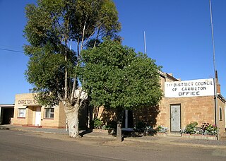
Carrieton is a small town situated in the Flinders Ranges of South Australia. It is located between the towns of Orroroo to the south and Cradock to the north.
The Regional Council of Goyder is a local government area located in the Mid North region of South Australia. The council area is reliant on agriculture as a mainstay of its economy, with manufacturing and tourism also becoming prominent. The council seat lies at Burra, with a branch office situated at Eudunda.
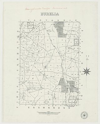
Eurelia is a town and locality in the Australian state of South Australia located on the east side of the Flinders Ranges about 264 kilometres (164 mi) north of the state capital of Adelaide and about 20 kilometres (12 mi) from the municipal seat of Orroroo.

Yatina is a town and locality in the Australian state of South Australia located on the RM Williams Way about 222 kilometres (138 mi) north of the state capital of Adelaide and about 31 kilometres (19 mi) and 21 kilometres (13 mi) respectively from the municipal seats of Jamestown and Orroroo.
Pekina is a town and locality in the Mid North region of South Australia. The town is located in the District Council of Orroroo Carrieton local government area, 270 kilometres (170 mi) north of the state capital, Adelaide. At the 2006 census, Pekina and the surrounding area had a population of 172. The name of the town is thought to derive from the Aboriginal word for "creek water".
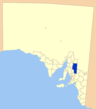
In South Australia, one of the states of Australia, there are many areas which are commonly known by regional names. Regions are areas that share similar characteristics. These characteristics may be natural such as the Murray River, the coastline, desert or mountains. Alternatively, the characteristics may be cultural, such as common land use. South Australia is divided by numerous sets of regional boundaries, based on different characteristics. In many cases boundaries defined by different agencies are coterminous.
The District Council of Orroroo was a local government area in South Australia, centred on the town of Orroroo. It was gazetted on 5 January 1888 under the provisions of the District Councils Act 1887 and included all the land defined by the hundreds of Black Rock Plain, Coomooroo, Erskine, Pekina, and Walloway in the County of Dalhousie.
The District Council of Carrieton was a local government area in South Australia, centred on the town of Carrieton from 1888 until 1997.
Coomooroo is a rural locality in the Mid North region of South Australia.

Walloway is a locality in the Australian state of South Australia located about 255 kilometres (158 mi) north of the state capital of Adelaide and about 10 kilometres (6.2 mi) north of the municipal seat of Orroroo.
Erskine is a locality in the Australian state of South Australia located about 250 kilometres (160 mi) north of the state capital of Adelaide and about 22 kilometres (14 mi) north-east of the municipal seat in Orroroo.

Yalpara is a locality in the Australian state of South Australia located about 265 kilometres (165 mi) north of the state capital of Adelaide and about 29 kilometres (18 mi) north-east of the municipal seat in Orroroo.
Minburra is a locality in the Australian state of South Australia located about 265 kilometres (165 mi) north of the state capital of Adelaide and about 29 kilometres (18 mi) north-east of the municipal seat in Orroroo.
Moockra is a locality in the Australian state of South Australia located on the eastern side of the Flinders Ranges about 274 kilometres (170 mi) north of the state capital of Adelaide and about 47 kilometres (29 mi) north-east and 36 kilometres (22 mi) south-east respectively of the municipal seats of Melrose and Quorn.

Johnburgh is a town and a locality in the Australian state of South Australia located on the eastern side of the Flinders Ranges about 275 kilometres (171 mi) north of the state capital of Adelaide and about 32 kilometres (20 mi) north-east of the municipal seat of Orroroo.
Yanyarrie is a locality in the Australian state of South Australia located on the eastern side of the Flinders Ranges about 289 kilometres (180 mi) north of the state capital of Adelaide and about and 45 kilometres (28 mi) north of the municipal seat of Orroroo.

