
The Mid Murray Council is a local government area in South Australia in the Murray and Mallee region of South Australia. The council spans the area from the Riverland through the Murraylands to the eastern slopes of the Mount Lofty Ranges. It includes 220 km of the Murray River. The council seat is at Mannum; it also maintains secondary offices at Cambrai and Morgan.

Karoonda is a town in the middle of the Murray Mallee region of South Australia. The current boundaries include the former town of Lowaldie, which was the next stop on the railway line away from Adelaide.

The Rural City of Murray Bridge is a local government area of South Australia, centred on the regional city of Murray Bridge and stretching south to Lake Alexandrina.
The Southern Mallee District Council is a local government area in the Murray and Mallee region of South Australia. The council offices are in Pinnaroo and Lameroo. It was established on 23 January 1997 when the District Council of Lameroo and District Council of Pinnaroo agreed to merge. Their predecessors date from 1908.

The District Council of Loxton Waikerie is a local government area in the Murray Mallee region of South Australia. The council seat lies at Loxton, while it maintains a branch office at Waikerie.
Mindarie is a small town in the Murray Mallee of South Australia between Karoonda and Loxton. The town was gazetted in 1912. The name Mindarie is believed to originate from the Dieri Aboriginal language, and possibly means "festival to invoke peace".
Marama is a town and a locality in the Australian state of South Australia located in the state's south-east about 146 kilometres (91 mi) east of the state capital of Adelaide and about 28 kilometres (17 mi) east of the municipal seat of Karoonda.
Nildottie is a locality in the Australian state of South Australia located on the east side of the Murray River about 99 kilometres (62 mi) east of the state capital of Adelaide and about 40 kilometres (25 mi) north-east of the municipal seat in Mannum.
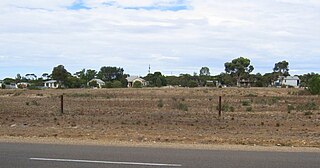
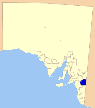
Wynarka is a very small town in South Australia 120 kilometres (75 mi) southeast of Adelaide on the Karoonda Highway (B55) and Loxton railway line in the Murray Mallee. Wynarka lies within the District Council of Karoonda East Murray.
Borrika is a town and locality in South Australia. It is on the Karoonda Highway 16 kilometres (9.9 mi) east of Karoonda, and was on the Barmera railway line, later known as the Loxton railway line when the end of the main line closed but the Loxton branch remained open until 2015 and has now also closed.
Copeville is a town and a locality in the Australian state of South Australia.
Galga is a settlement in the northern Murray Mallee region of South Australia. The town of Galga was surveyed in 1915 after the Waikerie railway line from Karoonda to Waikerie was opened in 1914. The line was shortened to Galga in 1990, and closed completely in 1994. There is a small bulk grain silo at Galga, but it is no longer regularly used. Galga has an active Country Fire Service brigade with one fire truck.
Halidon is a town and locality in the Australian state of South Australia located about 144 kilometres (89 mi) east of the state capital of Adelaide.
Sandalwood is a town and locality in the Australian state of South Australia located about 139 kilometres (86 mi) east of the state capital of Adelaide.
Wanbi is a town and locality in the Australian state of South Australia located about 157 kilometres (98 mi) east of the state capital of Adelaide and about 56 kilometres (35 mi) north-east of the municipal seat of Karoonda.

The Murraylands is a geographical region of the Australian state of South Australia (SA); its name reflects that of the river running through it. Lying due east of South Australia's capital city, Adelaide, it extends from the eastern slopes of the Mount Lofty Ranges to the border with the state of Victoria, a distance of about 180 kilometres. The north-to-south distance is about 130 kilometres. The region's economy is centred on agriculture, and tourism, especially along its 200-kilometre (120-mile) frontage of the River Murray.
Bowhill is a locality in South Australia. A settlement is located inside a bend on the left (eastern/southern) bank of the Murray River between Mannum and Swan Reach. It is predominantly shacks built facing the river bank. The settlement is in the Mid Murray Council area, but most of the locality is located away from the river and within the District Council of Karoonda East Murray, including the Lowan Conservation Park.
Mantung is a town and a locality in the Australian state of South Australia located in the state's south-east about 140 kilometres (87 mi) east of the state capital of Adelaide, and about 58 kilometres (36 mi) north-east and about 48 kilometres (30 mi) south-west respectively of the municipal seats of Karoonda and Loxton.
Bakara is a rural locality in the District Council of Karoonda East Murray of the Murray and Mallee region of South Australia which was established on 11 November 1999.
Mercunda is a town and a locality in the Australian state of South Australia located in the state's south-east about 134 kilometres (83 mi) east of the state capital of Adelaide, and about 52 kilometres (32 mi) north-east and about 53 kilometres (33 mi) south-west respectively of the municipal seats of Karoonda and Loxton.
