
Spokane County is a county located in the U.S. state of Washington. As of the 2010 census the population was 471,221, making it the fourth-most populous county in the state of Washington. The largest city and county seat is Spokane, the second largest city in the state after Seattle. The county is named after the Spokane tribe.

Coeur d'Alene is a city and the county seat of Kootenai County, Idaho, United States. It is the largest city in North Idaho and the principal city of the Coeur d'Alene Metropolitan Statistical Area. In 2020, the United States Census Bureau estimated the city's population at 53,354. Coeur d'Alene is a satellite city of Spokane, which is located about thirty miles (50 km) to the west in the state of Washington. The two cities are the key components of the Spokane–Coeur d'Alene Combined Statistical Area, of which Coeur d'Alene is the third-largest city. The city is situated on the north shore of the 25-mile (40 km) long Lake Coeur d'Alene and to the west of the Coeur d'Alene Mountains. Locally, Coeur d'Alene is known as the "Lake City," or simply called by its initials, "CDA."

Greenacres is a locale and former census-designated place (CDP) in Spokane County, Washington, United States. The locale is almost entirely split between the city of Spokane Valley and unincorporated Spokane County, with a small portion being located within the city of Liberty Lake. Greenacres retains its own post office.

Liberty Lake is a city in Spokane County, Washington, United States located adjacent to the eponymous lake. Located just over a mile west of the Washington–Idaho border, Liberty Lake is both a suburb of Spokane, Washington and a bedroom community to Coeur d'Alene, Idaho. The population was 7,591 at the 2010 census.
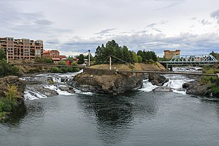
Spokane is the largest city and county seat of Spokane County, Washington, United States. It is in eastern Washington along the Spokane River adjacent to the Selkirk Mountains and west of the Rocky Mountain foothills, 92 miles (148 km) south of the Canadian border, 18 miles (30 km) west of the Washington–Idaho border, and 279 miles (449 km) east of Seattle along I-90.

Spokane Valley is a city in Spokane County, Washington, United States, and the largest suburb of Spokane. It is located east of Spokane, west of Coeur d'Alene, Idaho, and surrounds the city of Millwood on three sides. The city incorporated as the City of Spokane Valley on March 31, 2003. The Washington State Office of Financial Management estimates the city's population as 101,060 as of 2019. Spokane Valley is named after the valley of the Spokane River, in which it is located. The city and the general area is colloquially referred to as "The Valley" by residents of the Spokane–Coeur d'Alene area.

The Spokane Valley is a valley of the Spokane River through the southern Selkirk Mountains in the U.S. state of Washington. The valley is home to the cities of Spokane and its suburbs Spokane Valley, Liberty Lake, and Millwood. The valley is bounded on the north and south by the Selkirk Mountains, on the west by the Columbia River Basalt Group, and on the east by the Rathdrum Prairie at the Idaho state border. Mica Peak, located south of the valley, is the southernmost peak in the Selkirk Range. The mountain, along with surrounding peaks, separates the Spokane Valley from the Palouse. The Valley contains part of the Spokane Valley–Rathdrum Prairie Aquifer.
Spokane Transit Authority, more commonly Spokane Transit or STA, is the public transport authority of central Spokane County, Washington, United States, serving Spokane, Washington and its surrounding urban areas.

Battle Ground Lake State Park is a 275-acre (111 ha) public recreation area located three miles (4.8 km) northeast of the city of Battle Ground, Washington. The state park is covered by an evergreen forest located around a crater lake of volcanic origin. The park is managed by the Washington State Parks and Recreation Commission.

Brundage Mountain Resort is an alpine ski area in the western United States, located in west central Idaho in the Payette National Forest. Brundage first opened in November 1961 and is eight miles (13 km) northwest of McCall, a twenty-minute drive in average winter conditions.
Central Valley School District No. 356 is a K–12 public school district located in Spokane Valley and Liberty Lake, Washington. Over 14,700 students attend one of the twenty-one schools within the district.
Interstate 90 (I-90) is a transcontinental Interstate Highway that runs east–west across the northern United States. Within the state of Idaho, the freeway travels for 74 miles (119 km) from the Washington border near Spokane to Coeur d'Alene and the panhandle region at the north end of the state. After traveling through the Silver Valley along the Coeur d'Alene River in the Bitterroot Range, I-90 crosses into Montana at Lookout Pass.

Spokane, Washington has a rich sporting culture and the area residents are active in many spectator and participant sports. Although Spokane lacks any major, nationally recognized professional sports team, Spokane has a sports friendly atmosphere, and was recognized and rated #99 in the Sporting News 2006 "99 Best Sporting Cities" list. In 2009, Sports Business Journal rated Spokane as the fifth best minor league sports market in America out of 239 markets.

The economy of the Spokane Metropolitan Area plays a vital role as the hub for the commercial, manufacturing, and transportation center as well as the medical, shopping, and entertainment hub of the 80,000 square miles (210,000 km2) Inland Northwest region. Although the two have opted not to merge into a single Metropolitan Statistical Area (MSA) yet, the Coeur d'Alene MSA has been combined by the Census Bureau into the Spokane–Coeur d'Alene combined statistical area (CSA). The CSA comprises the Spokane metropolitan area and the Coeur d'Alene metropolitan area anchored by Coeur d'Alene, Idaho. According to the U.S. Bureau of Labor Statistics, the Spokane metropolitan area has a workforce of about 287,000 people and an unemployment rate of 5.3 percent as of February 2020; the largest sectors for non–farm employment are education and health services, trade, transportation, and utilities, and government. The Coeur d'Alene metropolitan area has a workforce of 80,000 people and an unemployment rate of 6.8% as of June 2020; the largest sectors for non-farm employment are trade, transportation, and utilities, government, and education and health services as well as leisure and hospitality. In 2017, the Spokane–Spokane Valley metropolitan area had a gross metropolitan product of $25.5 billion while the Coeur d'Alene metropolitan area was $5.93 billion.

The Spokane–Spokane Valley Metropolitan Statistical Area, as defined by the United States Census Bureau, is an area consisting of Spokane, Stevens, and Pend Oreille counties in Washington state, anchored by the city of Spokane and its largest suburb, Spokane Valley. As of July 1, 2018, the MSA had an estimated population of 573,493. The Spokane Metropolitan Area and the neighboring Coeur d'Alene metropolitan area, make up the larger Spokane–Coeur d'Alene combined statistical area. The urban areas of the two MSAs largely follow the path of Interstate 90 between Spokane and Coeur d'Alene. In 2010, the Spokane–Spokane Valley MSA had a gross metropolitan product of $20.413 billion.
The Saltese Uplands Conservation Area is a 522 acre conservation area in Spokane County in the U.S. state of Washington. The conservation area covers the Saltese Uplands, which are situated on the western slope of the Holiday Hills, immediately to the east of the adjacent Saltese Flats. The area is open to the public and contains 7 miles (11 km) of trails.
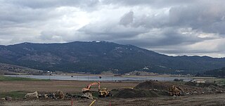
The Saltese Flats is a flat located in Spokane County, Washington, United States. The flats are occupied by the residual wetlands of the now-drained Saltese Lake. The term Saltese Flats is generally used to refer to both the flat and the occupying wetlands. The wetlands—which are overlooked by the Saltese Uplands—are primarily fed by Quinnamose and Saltese Creeks, and are also emptied by the latter.
Saltese Creek is an approximately 9 mi (14 km) long stream in Spokane County, Washington, United States. Originally only 3.5 miles (5.6 km), the lower 5.5 miles (8.9 km) of the stream, along with around 10 mi (16 km) of drainage canals were dug to drain Saltese Lake. The stream now functions as one of two primary inflows, as well as the primary outflow for the Saltese Flats. The stream has its headwaters near the summit of Mica Peak and terminates at Shelley Lake, which was created as a result of draining Saltese Lake.
Spokane Bridge is an unincorporated community and former census-designated place in Spokane County, in the U.S. state of Washington. The community is located on the banks of the Spokane River at the Washington–Idaho border, just south of Interstate 90. The city of Stateline, Idaho is located across the river to the northeast. The community was the site of the first post office in Spokane County

Sprague Avenue is a major east–west street serving Spokane, Spokane Valley, and Liberty Lake, Washington, United States. It travels approximately 17 miles (27 km), extending from Downtown Spokane eastward through Spokane Valley as an arterial road, and continues on as a collector road to its eastern terminus in Liberty Lake.

