
Staffordshire is a landlocked ceremonial county in the West Midlands of England. It borders Cheshire to the north-west, Derbyshire and Leicestershire to the east, Warwickshire to the south-east, the West Midlands county and Worcestershire to the south, and Shropshire to the west. The largest settlement is the city of Stoke-on-Trent, and the county town is Stafford.

Uttoxeter is a market town and civil parish in the East Staffordshire borough of Staffordshire, England. It is near to the Derbyshire county border.

Ashbourne is a market town in the Derbyshire Dales district in Derbyshire, England. Its population was measured at 8,377 in the 2011 census and was estimated to have grown to 9,163 by 2019. It has many historical buildings and independent shops. The town offers a historic annual Shrovetide football match. Its position near the southern edge of the Peak District makes it the closest town to Dovedale, to which Ashbourne is sometimes referred to as the gateway.
Mickleover is a village in the unitary authority of Derby, in Derbyshire, England. It is 2 miles (3.2 km) west of Derby, 10 miles (16 km) northeast of Burton upon Trent, 13 miles (21 km) southeast of Ashbourne and 12 miles (19 km) northeast of Uttoxeter.

East Staffordshire is a local government district with borough status in Staffordshire, England. The council is based in Burton upon Trent. The borough also contains the town of Uttoxeter and numerous villages and surrounding rural areas.

South Derbyshire is a local government district in Derbyshire, England. The district covers the towns of Melbourne and Swadlincote as well as numerous villages and hamlets such as Hilton, Hatton, Etwall, Aston-on-Trent, Repton, Weston-on-Trent and Willington. About a third of the National Forest lies within the district.

Staffordshire is a landlocked county in the West Midlands of England. It adjoins Cheshire to the north west, Derbyshire and Leicestershire to the east, Warwickshire to the south east, West Midlands and Worcestershire to the south, and Shropshire to the west. The historic county of Staffordshire includes Wolverhampton, Walsall, and West Bromwich, these three being removed for administrative purposes in 1974 to the new West Midlands authority. The resulting administrative area of Staffordshire has a narrow southwards protrusion that runs west of West Midlands to the border of Worcestershire. The city of Stoke-on-Trent was removed from the admin area in the 1990s to form a unitary authority, but is still part of Staffordshire for ceremonial and traditional purposes.
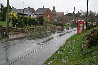
Rocester is a village and civil parish in the East Staffordshire district of Staffordshire, England. Its name is spelt Rowcestre in the Domesday Book. It is located on the Derbyshire border.

Marchington is a small village in East Staffordshire, England. It lies between the towns of Burton upon Trent and Uttoxeter. Marchington has a small community-run shop, a first school, two churches and two pubs. The population of the village was 1,127 at the 2001 census, increasing to 2,017 at the 2011 census.

Marchington Woodlands is a village and former civil parish, now in the parish of Marchington, in the East Staffordshire district, in the county of Staffordshire, England. It has a church and a village hall. The local first school was closed in 1981 and the building was converted into a private home. Marchington Woodlands consists mostly of farms and cottages. it is often Referred to by locals as The Woodlands. It is located near Uttoxeter. In 1931 the parish had a population of 273.
Denstone is a village and civil parish situated between the towns of Uttoxeter in East Staffordshire and Ashbourne in Derbyshire. It is located next to the River Churnet. The village has a church, village hall, primary school and a pub. The nearest railway station is at Uttoxeter for the Crewe to Derby line and the nearest airport is East Midlands Airport.

Uttoxeter Road is a cricket ground located along the Uttoxeter Road between the villages of Lower Tean and Checkley in Staffordshire. Completely surrounded by countryside, it is the home of Checkley Cricket Club.

The Heath is a village in the East Staffordshire borough of Staffordshire, England. It is close to the border with Derbyshire. The village adjoins the town of Uttoxeter and the villages of Bramshall and Spath.
Tean is a large village in the civil parish of Checkley in the Staffordshire Moorlands district, in the county of Staffordshire, England. It is around 15 miles (24 km) south-east of Stoke-on-Trent. The River Tean runs through the village, heading east towards Uttoxeter.

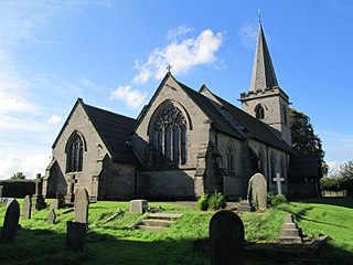
St Mary the Virgin's Church, Uttoxeter, commonly called simply St Mary's, is the parish church of the town of Uttoxeter, Staffordshire, England. Its tower and spire were built in the 14th century. They were designed by renowned architect Henry Yevele; the nave was rebuilt in 1828 and the chancel in 1877. It is a Grade II* listed building.
Checkley is a village and civil parish in the district of Staffordshire Moorlands in the English county of Staffordshire.
Kingstone is a village and civil parish within the English county of Staffordshire.
There are a number of listed buildings in Staffordshire. The term "listed building", in the United Kingdom, refers to a building or structure designated as being of special architectural, historical, or cultural significance. Details of all the listed buildings are contained in the National Heritage List for England. They are categorised in three grades: Grade I consists of buildings of outstanding architectural or historical interest, Grade II* includes significant buildings of more than local interest and Grade II consists of buildings of special architectural or historical interest. Buildings in England are listed by the Secretary of State for Culture, Media and Sport on recommendations provided by English Heritage, which also determines the grading.

