Cheadle, Staffordshire

Last updated

Cheadle
St Giles RC Church Cheadle Staffs tower.jpg
Staffordshire UK location map.svg
Red pog.svg
Cheadle
Location within Staffordshire
Population12,165 (2011) [1]
OS grid reference SK010431
District
Shire county
Region
Country England
Sovereign state United Kingdom
Post town Stoke-on-Trent
Postcode district ST10
Dialling code 01538
Police Staffordshire
Fire Staffordshire
Ambulance West Midlands
UK Parliament
List of places
UK
England
Staffordshire
52°59′06″N1°59′11″W / 52.9849°N 1.9865°W / 52.9849; -1.9865

Cheadle is a market town and civil parish in the Staffordshire Moorlands District of Staffordshire, England, with a population of 12,000 at the 2021 census. It is located between Uttoxeter, Leek, Ashbourne and Stoke-on-Trent.

Contents

History

Cheadle is an historic market town dating back to Anglo-Saxon times, being referred to in Domesday Book (1086). [2] It lies within the historic Staffordshire Hundred of Totmonslow: for administrative purposes, it is now part of the Staffordshire Moorlands area.

Cheadle appears in Domesday Book as "Celle" held by the lord of the manor, Robert of Stafford, at the time the area covered 6 miles by 3 miles and listed 9 families. In 1176 the Basset family acquired the manor of "Chedle" and in 1250 Ralph Basset was granted a market charter and annual fair by King Henry III.

Cheadle Market 2019 Cheadle, Staffordshire, market.jpg
Cheadle Market 2019

In 1309, 75 families are recorded as using a corn-grinding mill sited near Mill Road. Fifty years later, a new church was built in the village replacing a 12th-century structure and this church remained in use until 1837.

In 1606 a school was founded by the church, and in 1685 the then curate of the parish, Rev, Henry Stubbs, left an endowment to found a grammar school in Cheadle. The school was built at Monkhouse (behind the High Street) and was active until 1917. The endowment continues to this day. The Monkhouse is currently home to 3rd Cheadle Scout Group.

By 1676 Cheadle's population is recorded as just over one thousand, and a hundred years later (1772) as one thousand eight hundred. At this time the main source of employment was agriculture and farming. During the same period a new workhouse was built and opened. It was extended under the Cheadle Union an 1837. Part of the original building was demolished in 1909, renamed an infirmary. The whole complex was demolished in 1987 and a new hospital was built on the site, which was opened in 1989 by Princess Anne.

In 1798, 10 weavers houses were built. The weavers lived downstairs and the looms for the manufacture of tape were upstairs. By the 1820s the looms were transferred into a factory in Tape Street. This tape factory closed in 1972, and is now a shop. In 1851 silk and narrow fabric mills were built in Cheadle. They employed hundreds of operatives, and closed in 1981.

In the Brookhouses area of Cheadle in 1725, the Cheadle Brass and Copper Company started production, transferring to the Oakamoor area 100 years later under the company name Thomas Patten. It was bought in 1851 by Thomas Bolton of Birmingham. In 1890 Bolton's opened a factory at Froghall and the Oakamoor works were eventually closed in 1963.

St Giles' Catholic Church opened in 1846. Its 200 feet (61 m) spire still dominates the town today. [3] It was built by Augustus Welby Northmore Pugin, who was commissioned by John Talbot, 16th Earl of Shrewsbury to create a church that "would have no rival". To achieve his aim, Talbot gave Pugin unlimited resources with which to build it. [4] [5] The church is more commonly known as 'Pugin's Gem', and is the centre of a local tourist event known as 'Discover the Secret'. Cheadle Town Hall was completed in 1894. [6]

At the turn of the 20th century the first open air swimming baths were constructed at Brookhouses, and telephone installation began in 1904. In 1901 Cheadle was linked to the railway network by the Cheadle Railway, operated and later owned by the North Staffordshire Railway, with the building of a railway station at Majors Barn, giving access to further industries and movement of passengers. At a later period sand, gravel and aggregates used for building purposes were transported from the station as well as coal.

The first motor car arrived in Cheadle in 1903, and the first licensed omnibus service – Cheadle to Longton – commenced in January 1914.

One of the British Signals Intelligence Y-stations called RAF Cheadle was situated at Woodhead Hall, from land purchased by the Air Ministry playing a vital role in helping intercept German Luftwaffe radio communications during the Second World War.

Places of interest

N.E. chapel, St Giles' Catholic Church St Giles RC Church Cheadle Staffs NE chapel.jpg
N.E. chapel, St Giles' Catholic Church
St Giles' RC Church, Cheadle, Staffordshire St Giles Church Cheadle.jpg
St Giles' RC Church, Cheadle, Staffordshire

The 200 feet (61 m) spire of St Giles' Catholic Church dominates Cheadle's skyline. [3] Known as "Pugin's Gem", [7] it is considered to be the most complete expression of Pugin's beliefs about what a church ought to be, with everything in it having a practical and symbolic purpose. [3] The church featured heavily in local events celebrating the 200th anniversary of the birth of Pugin.

The town also has an Anglican church dedicated to St Giles. It was totally rebuilt in 1837–39 to the design of J. P. Pritchett, but incorporating fragments and furniture from the earlier church. There is also a strong Methodist tradition in Cheadle, and in the 19th century it was the various Methodist chapels around the Cheadle area which taught many of the young boys who worked on the farms or in the coal mines to read and write. There is a large modern Methodist church in the town.

To the south-east of Cheadle are the remains of Croxden Abbey, founded in 1176 by Bertram de Verdun for monks of the Cistercian Order. The abbey is a 5-mile walk from the town centre.

South-west end of High Street, near the parish church. Cheadle High Street.jpg
South-west end of High Street, near the parish church.

Cheadle is a base for exploring the Peak District National Park area, which is popular with walkers and rock climbers. Surrounded by lofty hills, Cheadle is the gateway to the wooded Churnet Valley and the Staffordshire Moorlands. It is also around 4 miles (6.4 km) from the Alton Towers Resort.

Cecilly Brook Local Nature Reserve is near the centre of town. It is one of the most important breeding sites for water voles in Staffordshire. [8] There are 42 acres of landscaped lakes at the JCB factory. Local leisure facilities are at Cheadle Recreation Ground and South Moorlands Leisure Centre.

The High Street of Cheadle has many old buildings and is little changed from how it looked in the Victorian era.

Economy

JCB Earthmovers factory JCB Earthmovers - geograph.org.uk - 221132.jpg
JCB Earthmovers factory

Cheadle is mentioned in Domesday Book as a small and unimportant hamlet with a small population. The town grew steadily over the next few hundred years, with the development of industry and agriculture. The historic industries that the town has depended on have been coal mining, silk, agriculture, brass making and the historic copper industry in nearby Froghall and Oakamoor. The town and the nearby village of Tean also had a textiles industry in tape weaving: the mill has since been converted into flats.

For hundreds of years the main industry in the Cheadle area was coal mining. The Cheadle Coalfield was part of the much larger North Staffordshire Coalfield. The town and the surrounding area were once home to over sixty mines, but the Industry declined in the 20th century, and one by one the remaining larger pits were closed; Parkhall (now the home to the JCB factories) and Hazlewall in the 1930s, New Haden in 1943 and Foxfield in 1965. However opencast mining and small scale adit mining carried on in Cheadle up until the 1990s.

Today the town's main employer is the large JCB factories. There are also several small industrial units on the site of the former New Haden Colliery and the local Alton Towers Resort employs many of its work force from the Cheadle area. A lot of people in the town commute to Stoke-on-Trent, Newcastle-under-Lyme, Uttoxeter and Derby.

Markets are held in the market place on Tuesdays, Fridays and Saturdays. [9]

Media

The Cheadle and Tean Times

Cheadle and Tean Times office Cheadle and Tean Times office.jpg
Cheadle and Tean Times office

The Cheadle and Tean Times has been publishing newspapers weekly in the town since 1896. The only family run and independent newspaper in North Staffordshire, it is known by townsfolk as the Stunner.

Other media

The weekly Cheadle Post & Times and the daily Sentinel newspapers also cover the town. Local radio stations are Signal 1 and Greatest Hits Radio Staffordshire & Cheshire from Stoke-on-Trent and BBC Radio Stoke. Community station Moorlands Radio covers the town from Leek.

Local TV coverage is provided by BBC West Midlands and ITV Central. Television signals are received from the Sutton Coldfield and the local relay transmitters. [10] [11]

Cheadle High School also operates an internet radio station for the local area, which has shows presented and produced by the high school radio. [ citation needed ]

Transport

Cheadle used to be served by a branch line opened in 1901 from Cresswell which was a station on the North Staffordshire Railway Crewe to Derby Line. It took almost thirty years of petitioning by the local coalmasters and notables in the town for the Cheadle Railway Company to build the small branch line and station. Even though the branch was only about four miles (6 km) long it was difficult to build as a tunnel had to be constructed under the huge Bunter Sandstone Hill at Huntley. The tunnel was very wet and plagued by problems with its roof. In the 1930s the LMS Railway, which had taken over the North Staffordshire Railway, built a diversion line around Huntley tunnel and abandoned it. The tunnel survives because it was used as a coal mine in the '70s and '80s, and the southern portal remains; however the northern portal has long been filled in. With the opening of the branch line to Cheadle it meant that New Haden Colliery and Parkhall Colliery now had connections to the rail network, and Cheadle in general had its long-awaited rail connection to the outside world. The line closed to passenger traffic in 1963 but remained open to serve local gravel quarries until 1982.

Today, the nearest railway station is Blythe Bridge on the Crewe-Derby Line.

Bus services to Cheadle were provided by PMT until it was bought out by First Group. The service 32, First Potteries operate an hourly service to Hanley. D&G Bus operate service 32X which also serves Hanley every hour and service E1 to Alton Towers. Town service 123 is operated by Bennetts while service 30 to Leek is operated by Aimee's, 3 times per day.

Notable people

Caricature of Henry Wiggin, published in Vanity Fair, 16 April 1892 Henry Wiggin Vanity Fair 16 April 1892.jpg
Caricature of Henry Wiggin, published in Vanity Fair , 16 April 1892
William Harris William Harris d.1911.jpg
William Harris

Sport

Schools

See also

Related Research Articles

<span class="mw-page-title-main">Staffordshire</span> County of England

Staffordshire is a landlocked ceremonial county in the West Midlands of England. It borders Cheshire to the north-west, Derbyshire and Leicestershire to the east, Warwickshire to the south-east, the West Midlands county and Worcestershire to the south, and Shropshire to the west. The largest settlement is the city of Stoke-on-Trent, and the county town is Stafford.

<span class="mw-page-title-main">Leek, Staffordshire</span> Human settlement in England

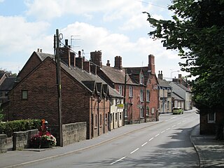
Leek is a market town and civil parish in Staffordshire, England, on the River Churnet 10 miles (16 km) north east of Stoke-on-Trent. It is an ancient borough and was granted its royal charter in 1214.

<span class="mw-page-title-main">Endon</span> Human settlement in England

Endon is a village within the Staffordshire Moorlands district of Staffordshire, England. It is 4 miles (6.4 km) southwest of Leek and 6 miles (9.7 km) north-northeast of Stoke-on-Trent. Endon was formerly a township in civil parish of Leek.

<span class="mw-page-title-main">Uttoxeter</span> Market town in Staffordshire, England

Uttoxeter is a market town and civil parish in the East Staffordshire borough of Staffordshire, England. It is near to the Derbyshire county border.

<span class="mw-page-title-main">Newcastle-under-Lyme</span> Market town in Staffordshire, England

Newcastle-under-Lyme is a market town and the administrative centre of the Borough of Newcastle-under-Lyme in Staffordshire, England. It is adjacent to the city of Stoke-on-Trent. In 2021 the population was 75,082.

<span class="mw-page-title-main">River Churnet</span> River in Staffordshire, England

The River Churnet is a river in Staffordshire, England. It is a tributary of the River Dove.

<span class="mw-page-title-main">Staffordshire Moorlands</span> Non-metropolitan district in England

Staffordshire Moorlands is a local government district in Staffordshire, England. Its council is based in Leek, the district's largest town. The district also contains the towns of Biddulph and Cheadle, along with a large rural area containing many villages. North-eastern parts of the district lie within the Peak District National Park.

<span class="mw-page-title-main">BBC Radio Stoke</span> Radio station in Stoke-on-Trent

BBC Radio Stoke is the BBC's local radio station serving Staffordshire and South Cheshire.

<span class="mw-page-title-main">Churnet Valley Railway</span> Heritage railway in Staffordshire, England

The Churnet Valley Railway is a preserved standard gauge heritage railway in the Staffordshire Moorlands of Staffordshire, England. It operates on part of the former Churnet Valley Line which was opened by the North Staffordshire Railway. The railway is roughly 10.5 miles (16.9 km) long from Kingsley and Froghall to Ipstones. The land from Leek Brook Junction to Ipstones was opened by Moorland & City Railways (MCR) in 2010 after they took a lease out from Network Rail. This has subsequently been purchased by the Churnet Valley Railway. The main stations along the line are Kingsley and Froghall, Consall, Cheddleton and Leek Brook. Work has begun to extend the line to the town of Leek which will act as the northern terminus of the line. The line between Leek and Waterhouses has also been reopened as part of the heritage railway as far as Ipstones.

<span class="mw-page-title-main">Dilhorne</span> Human settlement in England

Dilhorne is an ancient parish and village in Staffordshire, three miles from Cheadle and six miles from Stoke-on-Trent. The village is within the Staffordshire Moorlands area.

<span class="mw-page-title-main">Froghall</span> Human settlement in England

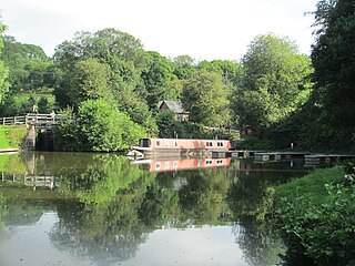
Froghall is a village situated approximately ten miles to the east of Stoke-on-Trent and two miles north of Cheadle in Staffordshire, England. Population details as taken at the 2011 Census can be found under Kingsley. Froghall sits in the Churnet Valley, a beautiful and relatively unspoilt part of Staffordshire. There are some excellent and challenging walks in the area, many of which encompass the area's historic development by the coal, ironstone, copper and limestone industries.

The Cheadle branch line was a railway line of just under 4 miles (6.4 km) in length that served the town of Cheadle, Staffordshire. It was in operation as a passenger line from 1892 to 1963, and closed altogether in 1986. It took 46 years from conception to completion and was notable in that part of the line had to be practically rebuilt partway through its existence.

<span class="mw-page-title-main">St Giles' Catholic Church, Cheadle</span> Church in England

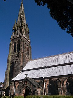
St Giles' Church is a Roman Catholic church in the town of Cheadle, Staffordshire, England. The Grade I listed Gothic Revival church was designed by Augustus Welby Northmore Pugin and built between 1841 and 1846 for the Earl of Shrewsbury. It is in Decorated style, and is highly decorated on the outside and the inside, and has a tall steeple. The interior is painted throughout, and is floored with patterned tiles. Almost all the furniture and fittings were designed by Pugin, including the piscina, sedilia, a recess for an Easter Sepulchre, the reredos, font, font cover, pulpit, and screen. The spire is 200 feet (61 m) high and the church by far the tallest building in the town.

Staffordshire Fire and Rescue Service is the statutory fire and rescue service responsible for fire protection, prevention, intervention and emergency rescue in the county of Staffordshire and unitary authority of Stoke-on-Trent. The county has a population of 1,126,200 and covers a total area of 2,260 km2. Staffordshire shares the majority of its border with Derbyshire, Cheshire, West Midlands (County) and Shropshire; although, in much shorter stretches, the county also butts up against Worcestershire, Warwickshire and Leicestershire.

The Churnet Valley line was one of the three original routes planned and built by the North Staffordshire Railway. Authorised in 1846, the line opened in 1849 and ran from North Rode in Cheshire to Uttoxeter in East Staffordshire. The line was closed in several stages between 1964 and 1988 but part of the central section passed into the hands of a preservation society and today operates as the Churnet Valley Railway.

Weston Coyney is a suburb of the City of Stoke-on-Trent in Staffordshire. It lies on the south eastern edge of the city and borders the neighbouring Staffordshire Moorlands district.

<span class="mw-page-title-main">Tean, Staffordshire</span> Human settlement in England

Tean is a large village in Staffordshire, England. It is around 15 miles (24 km) south-east of Stoke-on-Trent. The River Tean runs through the village, heading east towards Uttoxeter. Population details for the 2011 census can be found under Checkley.

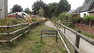
Leek railway station is the proposed and future terminus of the Churnet Valley Railway and is currently awaiting construction. It will be the second railway station in Leek.

<span class="mw-page-title-main">Biddulph Valley line</span> Railway in northwest England

The Biddulph Valley line was a double tracked line that ran from Stoke-on-Trent to Brunswick Wharf in Congleton. The line was named after the town of the same name as it ran via the Staffordshire Moorlands and covered areas of East Staffordshire and Cheshire.

<span class="mw-page-title-main">Cheadle Rural District</span> Former rural district in Staffordshire, England

Cheadle Rural District was a rural district in the administrative county of Staffordshire, England from 1894 to 1974, covering an area in the north of the county centred on the small town of Cheadle.

References

  1. "Town population 2011" . Retrieved 8 December 2015.
  2. Plant, Robert (1881). History of Cheadle, in Staffordshire, And Neighbouring Places. Leek: William Clemesha. p. 317 + xvi. ASIN B00088XLDW.
  3. 1 2 3 Exterior of the Church Archived 26 February 2011 at the Wayback Machine . Stgilescatholicchurch.co.uk. Retrieved 2012-09-16.
  4. Saint Giles Roman Catholic Church in 360°. Bbc.co.uk (2005). Retrieved 2012-09-16.
  5. Flickr images. Flickr.com. Retrieved 2012-09-16.
  6. "Town Hall, Cheadle". Staffordshire Past Track. Staffordshire County Council. Retrieved 30 March 2024.
  7. St Giles Roman Catholic Church Archived 12 September 2011 at the Wayback Machine . Cheadlestaffordshire.co.uk. Retrieved 2012-09-16.
  8. Cecilly Brook Local Nature Reserve Archived 12 September 2011 at the Wayback Machine . Cheadlestaffordshire.co.uk. Retrieved 2012-09-16.
  9. Staffordshire Moorlands District Council website Archived 27 September 2011 at the Wayback Machine
  10. "Sutton Coldfield (Birmingham, England) Full Freeview transmitter". UK Free TV. 1 May 2004. Retrieved 2 November 2023.
  11. "Freeview Light on the Cheadle (Staffordshire, England) transmitter". UK Free TV. Retrieved 2 November 2023.
  12. Wedgwoodmuseum.org.uk website archive retrieved January 2018
  13. Bernadette Swinnerton at Cycling Archives retrieved 3 March 2018
  14. SoccerBase Database retrieved January 2018

Further reading