The Derwent is a river in Derbyshire, England. It is 50 miles (80 km) long and is a tributary of the River Trent, which it joins south of Derby. Throughout its course, the river mostly flows through the Peak District and its foothills.

The Trent is the third longest river in the United Kingdom. Its source is in Staffordshire, on the southern edge of Biddulph Moor. It flows through and drains the North Midlands into the Humber Estuary. The river is known for dramatic flooding after storms and spring snowmelt, which in the past often caused the river to change course.

The River Tame is a river in the West Midlands of England, and one of the principal tributaries of the River Trent. The Tame is about 95 km (59 mi) long from the source at Oldbury to its confluence with the Trent near Alrewas, but the main river length of the entire catchment, i.e. the Tame and its main tributaries, is about 285 km (177 mi).
Blythe Bridge is a village in Staffordshire, England, south-east of Stoke-on-Trent.

The River Dove is the principal river of the southwestern Peak District, in the Midlands of England, and is around 45 miles (72 km) in length. It rises on Axe Edge Moor near Buxton and flows generally south to its confluence with the River Trent at Newton Solney. From there, its waters reach the North Sea via the Humber Estuary. For almost its entire course it forms the boundary between the counties of Staffordshire and Derbyshire. The river meanders past Longnor and Hartington and cuts through a set of deep limestone gorges, Beresford Dale, Wolfscote Dale, Milldale and Dovedale.
Blithfield is a civil parish in the East Staffordshire district of Staffordshire, England. It includes the settlements of Admaston, Newton along with Blithfield Hall, home of the Bagot family since 1360. It is situated 7.5 miles (12.1 km) south-west of Uttoxeter and 5.3 miles (8.5 km) north of Rugeley. Blithfield and Admaston comprise 1,414 acres (572 ha) of land, with Newton occupying 1,744 acres (706 ha). The nearest railway stations are Rugeley Trent Valley 4.5 miles (7.2 km) and Rugeley Town 6.0 miles (9.7 km).
The Bourne Brook or Black Brook, as it is known in its upper reaches, is a tributary of the River Tame in Staffordshire, England.

The River Sence is a river which flows in Leicestershire, England. The tributaries of the Sence, including the Saint and Tweed, fan out over much of western Leicestershire from Charnwood Forest and Coalville in the north-east to Hinckley and almost to Watling Street in the south and south-west. Its watershed almost coincides with Hinckley and Bosworth Borough of Leicestershire, which was formed in 1974 by amalgamation of Market Bosworth Rural District and Hinckley Urban District. It flows into the Anker, which in turn flows into the River Tame. It is part of the wider River Trent catchment, which covers much of central England. In 1881, Sebastian Evans wrote that the usual names for this river were Shenton Brook and Sibson Brook.

Piethorne Brook is a watercourse in Greater Manchester. It is a tributary of the River Beal.

Mavesyn Ridware is a village and civil parish in Lichfield District, Staffordshire, England. The parish had a population of 1,048 in 2001, increasing to 1,128 at the 2011 Census. It includes the villages of Hill Ridware, Rake End, Pipe Ridware and Blithbury, all of which lie between the River Trent and a small tributary, the River Blithe. To the east is the parish of Hamstall Ridware and to the south the larger village of Armitage.

Leigh is a civil parish in the English county of Staffordshire. The parish includes the village of Church Leigh, together with the settlements of Withington, Upper Leigh, Lower Leigh, Morrilow Heath, Middleton Green, Dodsley, Godstone, Nobut and Field.

The Wom Brook is a stream in South Staffordshire, England. It flows through the large village of Wombourne, and has played an important part in its industrial history. It is an important tributary of the River Smestow and part of the Severn catchment.

The River Dove is a river that extends through the Low Valley in Barnsley, England. It flows from Worsbrough Reservoir to its confluence with the River Dearne.

Ford Green Brook flows through Staffordshire and the outlying areas of Stoke-on-Trent, England. It is the first named tributary stream of the River Trent, and is 6.2 miles (10 km) long.
Kingstone is a village and civil parish within the English county of Staffordshire.

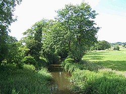
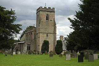
The Church of St Michael and All Angels is a parish church and Grade I listed building in the village of Hamstall Ridware, Staffordshire. The church is situated in a remote position to the north of the village accessed by a 250 m (820 ft) pathway through pasture land. The church is situated on a gentle slope 160 m (520 ft) west of the River Blithe. The church was founded in 1130—1150 but the majority of the present church was built of ashlar sandstone in the 14th and 15th centuries.

The River Swarbourn is a minor tributary of the River Trent that flows for 10 miles (16 km) in Staffordshire, England.
Fowlea Brook rises in Staffordshire and flows through the northern parts of Stoke-on-Trent, England. It is a tributary stream of the River Trent, and is 6 miles (9.7 km) long.

Lyme Brook is a tributary stream of the River Trent, which flows through Newcastle-under-Lyme, and the outlying areas of Stoke-on-Trent in Staffordshire, England.

The River Bourne flows for 10.9 miles (17.6 km) through North Warwickshire, England, and is a tributary of the River Tame. In the 19th century, the river with its undeveloped catchment close to Birmingham, was selected to provide a source of clean drinking water for the city.