Borough of Stafford

Last updated

Borough of Stafford
Bridge Street - geograph.org.uk - 1962032.jpg
Bridge Street in Stafford, the borough's main town.
Stafford UK locator map.svg
Stafford shown within Staffordshire
Sovereign state United Kingdom
Constituent country England
Region West Midlands
Non-metropolitan county Staffordshire
Status Non-metropolitan district
Admin HQ Stafford
Government
  TypeNon-metropolitan district council
  BodyStafford Borough Council
   MPs Bill Cash
Theodora Clarke
Area
  Total231.0 sq mi (598.2 km2)
  Rank59th (of 296)
Population
 (2021)
  Total137,231
  Rank167th (of 296)
  Density590/sq mi (230/km2)
Ethnicity (2021)
[1]
   Ethnic groups
List
Religion (2021)
[1]
   Religion
List
Time zone UTC0 (GMT)
  Summer (DST) UTC+1 (BST)
ONS code 41UG (ONS)
E07000197 (GSS)
OS grid reference SJ9213623094

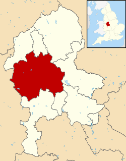
The Borough of Stafford is a local government district with borough status in Staffordshire, England. It is named after Stafford, its largest town, which is where the council is based. The borough also includes the towns of Stone and Eccleshall, as well as numerous villages and surrounding rural areas.

Contents

The neighbouring districts are Newcastle-under-Lyme, Stoke-on-Trent, Staffordshire Moorlands, East Staffordshire, Lichfield, Cannock Chase, South Staffordshire, Telford and Wrekin and Shropshire.

History

The town of Stafford was an ancient borough, being described as a borough in the Domesday Book of 1086. [2] Its earliest surviving charter was issued by King John in 1206. [3] Stafford was formally incorporated in 1614 by a charter from James I, which also granted the right to appoint a mayor. [4]

The borough was reformed in 1836 to become a municipal borough under the Municipal Corporations Act 1835, which reformed many boroughs across the country. As part of those reforms the borough was enlarged to include the Forebridge area on the south bank of the River Sow, which had been added to the Stafford parliamentary borough (constituency) in 1832. [5] [6] The municipal borough was subsequently enlarged several times to take in the town's growing suburbs, notably in 1917 when it gained areas including Tillington, and in 1934 when it gained areas including Baswich. [7]

The modern district was created on 1 April 1974 under the Local Government Act 1972 covering four former districts, which were all abolished at the same time: [8]

The new district was named Stafford after its largest town. [9] Stafford's borough status transferred to the new district from its creation, allowing the chair of the council to take the title of mayor, continuing Stafford's series of mayors dating back to 1614. [10]

Many of the new borough's parishes had been within the historic Hundred of Pirehill.

Governance

Stafford Borough Council
Stafford Borough Council.svg
Type
Type
Leadership
Andy Cooper,
Conservative
since 13 May 2023 [11]
Aidan Godfrey,
Labour
since 13 May 2023
Tim Clegg
since 2016 [12]
Structure
Seats40 councillors
Political groups
Administration (25)
  Labour (13)
  Borough Ind. (7)
  Green (5)
Other parties (15)
  Conservative (14)
  Liberal Democrats (1)
Elections
First past the post
Last election
4 May 2023
Next election
6 May 2027
Meeting place
Stafford Borough Council's offices - geograph.org.uk - 2539043.jpg
Civic Centre, Riverside, Stafford, ST16 3AQ
Website
www.staffordbc.gov.uk

Stafford Borough Council provides district-level services. County-level services are provided by Staffordshire County Council. Much of the borough is also covered by civil parishes, which form a third tier of local government. [13] [14]

Political control

The council has been under no overall control since 2022. Following the 2023 election a coalition of Labour, the Greens and local party the Stafford Borough Independents formed to take control of the council, led by Labour councillor Aidan Godfrey. [15]

The first elections to the enlarged borough council were held in 1973, initially operating as a shadow authority alongside the outgoing authorities until the new arrangements came into effect on 1 April 1974. Political control of the council since 1974 has been as follows: [16]

Party in controlYears
No overall control 1974–1995
Labour 1995–1999
No overall control 1999–2003
Conservative 2003–2022
No overall control 2022–present

Leadership

The role of mayor is largely ceremonial in Stafford. Political leadership is instead provided by the leader of the council. The leaders since 1974 have been: [17]

CouncillorPartyFromTo
Walter Dean [18] [19] Conservative 1 Apr 1974Jul 1991
Mike Heenan [20] [21] Conservative Sep 199113 Dec 1994
Walter Dean [22] [23] [24] Conservative 13 Dec 1994May 1995
Jack Kemp [25] [26] Labour May 199512 May 2003
Judith Dalgarno [27] [28] Conservative 12 May 20032009
Mike Heenan [29] Conservative 200920 Jan 2015
Patrick Farrington [30] Conservative 3 Feb 20157 May 2023
Aidan Godfrey Labour 13 May 2023

Composition

Following the 2023 election the composition of the council was: [31]

PartyCouncillors
Conservative 14
Labour 13
Stafford Borough Independents7
Green 5
Liberal Democrats 1
Total40

The next election is due in 2027.

Elections

Since the last boundary changes in 2015 the council has comprised 40 councillors representing 23 wards, with each ward electing one, two or three councillors. Elections are held every four years. [32]

Premises

The council is based at the Civic Centre on Riverside in the centre of Stafford. The building was purpose-built for the council and completed in 1978. [33] [34] Full council meetings are held at County Buildings on Martin Street. [35] Prior to the completion of the Civic Centre in 1978 the council had its main offices at Borough Hall and met at the Guildhall in Market Square, which had been built in 1935 on the site of an earlier guildhall. [36] [37] Borough Hall was subsequently converted into an events venue and the Guildhall was converted into a shopping centre, being largely rebuilt behind the 1935 frontage.

Towns and parishes

The Trent and Mersey Canal at Stone, the district's second largest town. The Trent and Mersey Canal at Stone - geograph.org.uk - 962538.jpg
The Trent and Mersey Canal at Stone, the district's second largest town.
Eccleshall, the borough's other town. Eccleshall High Street - geograph.org.uk - 4591629.jpg
Eccleshall, the borough's other town.

The main part of the Stafford urban area, roughly corresponding to the pre-1974 borough, is an unparished area. Nearly half the modern borough's population lives in this area. [38] The rest of the borough is divided into civil parishes. The parish council for Stone has declared that parish to be a town, allowing it to take the style "town council". Eccleshall is also commonly described as a town, having held a market charter from at least 1154, but its parish council has not formally declared it to be a town, nor is it a post town. The small parishes of Ellenhall and Marston have a parish meeting rather than a parish council. [39]

The parishes are:

Related Research Articles

<span class="mw-page-title-main">Basingstoke and Deane</span> Borough and non-metropolitan district in England

Basingstoke and Deane is a local government district with borough status in Hampshire, England. The main town is Basingstoke, where the council is based. The district also includes the towns of Tadley and Whitchurch, along with numerous villages and surrounding rural areas. The modern district was created in 1974, initially being called Basingstoke. It changed its name to "Basingstoke and Deane" in 1978 at the same time that it was made a borough; Deane was added to the name to represent the rural parts of the borough, being the area's smallest village.

<span class="mw-page-title-main">King's Lynn and West Norfolk</span> Borough and non-metropolitan district in England

King's Lynn and West Norfolk is a local government district with borough status in Norfolk, England. Its council is based in the town of King's Lynn. The district also includes the towns of Downham Market and Hunstanton, along with numerous villages and surrounding rural areas. The population of the district at the 2021 census was 154,325.

<span class="mw-page-title-main">East Staffordshire</span> Non-metropolitan district and Borough in England

East Staffordshire is a local government district with borough status in Staffordshire, England. The council is based in Burton upon Trent. The borough also contains the town of Uttoxeter and numerous villages and surrounding rural areas.

<span class="mw-page-title-main">South Staffordshire</span> Non-metropolitan district in England

South Staffordshire is a local government district in Staffordshire, England. Its council is based in Codsall. Other notable settlements include Brewood, Cheslyn Hay, Coven, Essington, Featherstone, Four Ashes, Great Wyrley, Huntington, Kinver, Landywood, Penkridge, Perton, Wedge Mills, Weston-under-Lizard and Wombourne. The district covers a largely rural area lying immediately to the west and north-west of the West Midlands conurbation.

<span class="mw-page-title-main">Staffordshire Moorlands</span> Non-metropolitan district in England

Staffordshire Moorlands is a local government district in Staffordshire, England. Its council is based in Leek, the district's largest town. The district also contains the towns of Biddulph and Cheadle, along with a large rural area containing many villages. North-eastern parts of the district lie within the Peak District National Park.

<span class="mw-page-title-main">Borough of Guildford</span> Borough and non-metropolitan district in England

The Borough of Guildford is a local government district with borough status in Surrey, England. With around half of the borough's population, Guildford is its largest settlement and only town, and is where the council is based.

<span class="mw-page-title-main">City of Winchester</span> Place in England

Winchester, or the City of Winchester, is a local government district with city status in Hampshire, England.

<span class="mw-page-title-main">Borough of Newcastle-under-Lyme</span> Non-metropolitan district and borough in England

The Borough of Newcastle-under-Lyme is a local government district with borough status in Staffordshire, England.

<span class="mw-page-title-main">Cannock Chase District</span> Non-metropolitan district in England

Cannock Chase is a local government district in Staffordshire, England. It is named after and covers a large part of Cannock Chase, a designated Area of Outstanding Natural Beauty. The council is based in the town of Cannock. The district also contains the towns of Hednesford and Rugeley, as well as a number of villages and surrounding rural areas.

<span class="mw-page-title-main">Lichfield District</span> Non-metropolitan district in England

Lichfield District is a local government district in Staffordshire, England. The district is named after its largest settlement, the city of Lichfield, which is where the district council is based. The district also contains the towns of Burntwood and Fazeley, along with numerous villages and surrounding rural areas, including part of Cannock Chase, a designated Area of Outstanding Natural Beauty.

<span class="mw-page-title-main">Congleton (borough)</span> Local government district in Cheshire, England

Congleton was, from 1974 to 2009, a local government district with borough status in Cheshire, England. It included the towns of Congleton, Alsager, Middlewich and Sandbach. The headquarters of the borough council were located in Sandbach.

<span class="mw-page-title-main">Mansfield District</span> Non-metropolitan district in England

Mansfield District is a local government district in Nottinghamshire, England. It is named after the town of Mansfield, where the council is based. The district also contains Mansfield Woodhouse and Warsop.

<span class="mw-page-title-main">Stone (UK Parliament constituency)</span>

Stone is a constituency in Staffordshire, represented in the House of Commons of the UK Parliament since its 1997 recreation by Sir Bill Cash, a Conservative. On 9 June 2023, he announced his intention to stand down at the next general election.

<span class="mw-page-title-main">Wyre Forest District</span> Non-metropolitan district in England

Wyre Forest is a local government district in Worcestershire, England. It is named after the ancient woodland of Wyre Forest. The largest town is Kidderminster, where the council is based. The district also includes the towns of Stourport-on-Severn and Bewdley, along with several villages and surrounding rural areas.

<span class="mw-page-title-main">Warwickshire County Council</span>

Warwickshire County Council is the county council that governs the non-metropolitan county of Warwickshire in England. Its headquarters are at Shire Hall in the centre of Warwick, the county town. The council's principal functions are county roads and rights of way, social services, education and libraries, but it also provides numerous other local government services in its area.

<span class="mw-page-title-main">Stoke-on-Trent City Council</span>

Stoke-on-Trent City Council is the local authority of Stoke-on-Trent, Staffordshire, England. As a unitary authority, it has the combined powers of a county council and district council and is administratively separate from the rest of Staffordshire.

<span class="mw-page-title-main">Staffordshire County Council</span> British administrative authority

Staffordshire County Council is the upper-tier local authority for the non-metropolitan county of Staffordshire, England. The non-metropolitan county differs from the ceremonial county, which additionally includes Stoke-on-Trent.

<span class="mw-page-title-main">Worcester City Council</span> Local authority for the city of Worcester, England

Worcester City Council is the local authority for Worcester, a non-metropolitan district with city status in Worcestershire, England. The council consists of 35 councillors, elected from 15 wards.

<span class="mw-page-title-main">Tamworth Borough Council</span> Local authority In England

Tamworth Borough Council is the local authority for the borough of Tamworth in the county of Staffordshire, England. The council consists of 30 councillors, three for each of the 10 wards in the town. It is currently under no overall control, led by Conservative councillor Thomas Jay. The borough council is based at Marmion House.

<span class="mw-page-title-main">City of Lincoln Council</span>

The City of Lincoln Council is the local authority for the district of Lincoln, in the county of Lincolnshire, England. The council consists of 33 councillors, three for each of the 11 wards in the city. It is currently controlled by the Labour Party, led by Ric Metcalfe. The administrative headquarters is at Lincoln City Hall although council meetings are held at the guildhall.

References

  1. Shares grouped parish council with Milwich
  2. Shares grouped parish council with Weston
  3. Shares grouped parish council with Tixall
  4. Shares grouped parish council with Fradswell
  5. Shares grouped parish council with Ingestre
  6. Shares grouped parish council with Gayton
  1. 1 2 UK Census (2021). "2021 Census Area Profile – Stafford Local Authority (E07000197)". Nomis. Office for National Statistics . Retrieved 5 January 2024.
  2. Report of the Commissioners Appointed to Inquire into the Municipal Corporations in England and Wales: Appendix 3. 1835. p. 2025. Retrieved 29 December 2023.
  3. The Royal Charters and Letters Patent Granted to the Burgesses of Stafford, A.D. 1206–1828 . Retrieved 29 December 2023.
  4. "History of Stafford". Stafford Borough Council. Retrieved 29 December 2023.
  5. Municipal Corporations Act. 1835. p. 458. Retrieved 29 December 2023.
  6. Parliamentary Boundaries Act. 1832. p. 359. Retrieved 29 December 2023.
  7. "Stafford Civil Parish". A Vision of Britain through Time. GB Historical GIS / University of Portsmouth. Retrieved 29 December 2023.
  8. "The English Non-metropolitan District (Definition) Order 1972", legislation.gov.uk , The National Archives, SI 1972/2039, retrieved 17 November 2023
  9. "The English Non-metropolitan Districts (Names) Order 1973", legislation.gov.uk , The National Archives, SI 1973/551, retrieved 31 May 2023
  10. "District Councils and Boroughs". Parliamentary Debates (Hansard) . 28 March 1974. Retrieved 4 December 2021.
  11. "Council minutes, 13 May 2023" (PDF). Stafford Borough Council. Retrieved 29 December 2023.
  12. Calkin, Sarah (27 July 2016). "Borough appoints new chief". Local Government Chronicle. Retrieved 29 December 2023.
  13. "Local Government Act 1972", legislation.gov.uk , The National Archives, 1972 c. 70, retrieved 31 May 2023
  14. "Election Maps". Ordnance Survey. Retrieved 27 December 2023.
  15. Madeley, Peter (16 May 2023). "New council leader to bring 'positive change' to Stafford after Labour gains". Express and Star. Retrieved 29 December 2023.
  16. "Compositions calculator". The Elections Centre. Retrieved 9 September 2022.
  17. "Council minutes". Stafford Borough Council. Retrieved 29 December 2023.
  18. "We'll pay less than some". Staffordshire Newsletter. Stafford. 29 March 1974. p. 6. Retrieved 16 September 2022. ...the leader of the new council, Councillor Walter Dean...
  19. Elliot, Amanda (18 July 1991). "Heenan tipped to take over as Tories' leader". Stafford Post. p. 2. Retrieved 16 September 2022.
  20. "New leader". Stafford Post. 12 September 1991. p. 19. Retrieved 16 September 2022.
  21. "Tories urged to elect newcomer". Staffordshire Newsletter. Stafford. 9 December 1994. p. 15. Retrieved 16 September 2022.
  22. "Veteran Tory set for return". Staffordshire Newsletter. Stafford. 2 December 1994. p. 1. Retrieved 16 September 2022.
  23. "New Tory leader". Staffordshire Newsletter. Stafford. 16 December 1994. p. 7. Retrieved 16 September 2022.
  24. "Labour sweep into power". Staffordshire Newsletter. Stafford. 5 May 1995. p. 1. Retrieved 16 September 2022.
  25. "Jobs vow by new leader". Evening Sentinel. Stoke-on-Trent. 6 May 1995. p. 4. Retrieved 16 September 2022.
  26. "Cabinet minutes, 4 March 2003" (PDF). Stafford Borough Council. Archived from the original (PDF) on 20 September 2013. Retrieved 16 September 2022.
  27. "Council minutes, 12 May 2003" (PDF). Stafford Borough Council. Archived from the original (PDF) on 17 September 2013. Retrieved 16 September 2022.
  28. Ashdown, Kerry (9 April 2020). "Tributes paid to popular shopkeeper and former council leader". Stoke Sentinel. Retrieved 16 September 2022.
  29. "Stafford Borough Council leader Mike Heenan 'to step down'". BBC News. 7 January 2015. Retrieved 16 September 2022.
  30. "Councillor Patrick M. M. Farrington". Stafford Borough Council. Retrieved 16 September 2022.
  31. "Local elections 2023: live council results for England". The Guardian.
  32. "The Stafford (Electoral Changes) Order 2015", legislation.gov.uk , The National Archives, SI 2015/69, retrieved 29 December 2023
  33. "Construction Site for Stafford Borough Council Offices, Riverside, Stafford". Staffordshire Past Track. Retrieved 13 February 2021.
  34. "No. 47702". The London Gazette . 1 December 1948. p. 14484.
  35. "Council agenda, 20 November 2023" (PDF). Stafford Borough Council. Retrieved 30 December 2023.
  36. Pullan, W. A., ed. (1976). Municipal Year Book. London: Municipal Journal. p. 890.
  37. "Opening of Stafford's New Guildhall". Stafford Newsletter. 27 July 1935. pp. Supplement pages 1–4. Retrieved 30 December 2023.
  38. "Stafford". City Population. Retrieved 30 December 2023.
  39. "Parish Councils and clerks". Stafford Borough Council. Retrieved 30 December 2023.

52°48′18.05″N2°6′59.99″W / 52.8050139°N 2.1166639°W / 52.8050139; -2.1166639