
Shropshire is a ceremonial county in the West Midlands of England, on the Welsh border. It is bordered by Wrexham County Borough and Cheshire to the north, Staffordshire to the east, Worcestershire to the south-east, Herefordshire to the south and Powys to the west. The largest settlement is Telford, and Shrewsbury is the county town.

Newport is a market town in the borough of Telford and Wrekin in Shropshire, England. It lies 7 miles (11 km) north-east of Telford town centre, 12 miles (19 km) west of Stafford, and is near the Shropshire-Staffordshire border. The 2001 census recorded 10,814 people living in the town's parish, which rose to 11,387 by the 2011 census.

Market Drayton is a market town and civil parish on the banks of the River Tern in Shropshire, England. It is close to the Cheshire and Staffordshire borders. It is located between the towns of Whitchurch, Wem, Nantwich, Newcastle-under-Lyme, Newport and the city of Stoke on Trent. The town is on the Shropshire Union Canal and bypassed by the A53 road.

Norbury is a village and civil parish in the Borough of Stafford, in west Staffordshire, England. The population as taken at the 2011 census was 371.

Norbury Junction is a hamlet and former canal junction which lies about 1 mile (1.6 km) to the south east of Norbury, in Staffordshire, England. The junction is where the Shrewsbury Canal meets the main line of the Shropshire Union Canal. Both canals opened in 1835 but the Shrewsbury Canal closed in 1944. The main line still runs through the former junction.
Adbaston is a village and a civil parish in the English county of Staffordshire.

Haughton is a village in Staffordshire, England, approximately 4 miles outside and to the west of the county town of Stafford. It lies on the A518 between Stafford and Gnosall. The name derives from a combination of the Mercian word halh meaning 'nook' and the Old English word tun meaning 'settlement', 'enclosure' or 'village.'

Little Hereford is a small village and civil parish in Herefordshire, England. The civil parish includes the hamlet of Middleton. The population of the civil parish at the 2011 census was 394.

Chirbury is a village and former civil parish, now in the parish of Chirbury with Brompton, in the Shropshire district, in west Shropshire, England. It is situated in the Vale of Montgomery, close to the Wales–England border, which is to its north, west and south. The A490 and B4386 routes cross at Chirbury.
Gnosall was a rural district in Staffordshire, England from 1894 to 1934. It was formed under the Local Government Act 1894 from that part of the Newport Rural Sanitary District which was in Staffordshire.
John Wedge was an English agriculturalist.
Thomas Wedge (1760–1854) was an English agriculturalist. He was the son of Francis Wedge (1714–1784) of Fernhill House, near Forton, Staffordshire, a prosperous farmer, and brother of John Wedge and Charles Wedge of Shudy Camps. Thomas Wedge established himself on farms near Sealand, Flintshire where he prospered on the land.
Charles Wedge (1746–1842), English farmer and surveyor, was the son of Sir Francis Wedge of Aqualate Park at Forton, Staffordshire, and the brother of John Wedge and Thomas Wedge. In 1776 he married Elizabeth Fletcher, at St Mary Woolnoth, London. They had seven surviving children. The second son was John Helder Wedge (1793–1872), emigrant to Tasmania.
This is a list of the sheriffs and high sheriffs of Staffordshire.
Colwich is a civil parish and village in Staffordshire, England. It is situated off the A51 road, about 3 miles (5 km) north-west of Rugeley and 7 miles (11 km) south-east of Stafford. It lies principally on the north-east bank of the River Trent, near Wolseley Bridge and just north of The Chase. The parish comprises about 2,862 hectares (28.62 km2) of land in the villages and hamlets of Colwich, Great Haywood, Little Haywood, Moreton, Bishton and Wolseley Bridge.

Aqualate Mere, in Staffordshire, is the largest natural lake in the English Midlands and is managed as a national nature reserve (NNR) by Natural England.

Aqualate Hall, a 20th-century country house, is located in Forton, Staffordshire, England, some 2 miles (3.2 km) east of the market town of Newport, Shropshire and 10 miles (16 km) west of the county town of Stafford. It is a Grade II* listed building.
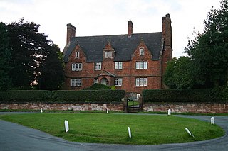
Forton Hall is a 17th-century country house situated in the village of Forton, Staffordshire, close to the Shropshire border at Newport. It is a Grade II* listed building.
Samuel Dugard (1645?–1697), was an English divine.
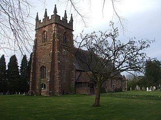
Forton is a civil parish in the Borough of Stafford, Staffordshire, England. It contains eleven listed buildings that are recorded in the National Heritage List for England. Of these, three are at Grade II*, the middle of the three grades, and the others are at Grade II, the lowest grade. The parish contains the village of Forton and the surrounding area, which includes Aqualate Park. In the park is Aqualate Hall, a country house which is listed, together with other buildings in the park. The other listed buildings are houses, a church, a bridge, and a structure which is either a folly or and ruined windmill.

