Hixon, Staffordshire

Last updated

Hixon
St. Peter, Hixon - geograph.org.uk - 119555.jpg
The Parish Church of Saint Peter
Staffordshire UK location map.svg
Red pog.svg
Hixon
Location within Staffordshire
Population1,917 (2011) [1]
  London 136
District
Shire county
Region
Country England
Sovereign state United Kingdom
Post town STAFFORD
Postcode district ST18
Dialling code 01889
Police Staffordshire
Fire Staffordshire
Ambulance West Midlands
List of places
UK
England
Staffordshire
52°49′40″N2°00′00″W / 52.8279°N 1.9999°W / 52.8279; -1.9999

Hixon is a village and a civil parish in the English county of Staffordshire. [2] [3]
grid reference SK003259

Contents

Location

The village is 7.8 miles (12.6 km) east of the town of Stafford, 9.9 miles (15.9 km) southeast of the town of Stone, 6.4 miles (10.3 km) northwest of the town of Rugeley and 8.6 miles (13.8 km) south west of Uttoxeter. The nearest railway station is at Rugeley. The nearest main roads are the A518 which skirts 1.3 miles (2.1 km) north of the village, and the A51 which runs to the west. [4]

History

Etymology

The genesis of the village name is said to be of Scandinavian origin. The first part, Hus is thought to be the Viking word for house. [5] The last part Dun is an old English word for Hill, so giving the origins as The House on the Hill. [5] Another school of thought originates the name from a person known as Hyht with the following es indicating it in the possession and can be interpreted as Hyht's hill. Over the years the village has been recorded under the names Huchtesdona in 1130, Huhtesdon and Huytesdon. [5]

The Domesday Book

Hixon is listed in the Domesday Book of 1086. In the survey the village has the name Hustedone. [6] and was described as being very small with five households. The village assets included two ploughs, a meadow and 3 acres. The head of the manor was Haywood. In 1066 the lord of the manor was the Bishop of Chester. In 1086 the lord of the manor was Nigel of Stafford and the Bishop of Chester was now the tenant-in-chief. [7] The survey also states that the value of the parish was 10s 9d.

RAF Hixon

During the Second World War, Hixon was the location of a Royal Air Force Station built for RAF Bomber Command. The station opened in 1942 [8] on a site located 0.9 miles (1.4 km) north west of the village and had the station identification code of HX. Three intersecting concrete runways were built on the station, which were surfaced with tarmac for use by Class-A bombers. The station building and technical site were located on the south east of the station and included accommodation and communal facilities for 2,938 RAF personnel. [8] There were also four T-2 type hangars and one MAP B-1 aircraft hangar. Overseeing the station was a 1941 pattern control tower which still survives and is currently being used as industrial offices. [9] During the war bomber aircraft that used the airfield included Vickers Wellingtons, Avro Lancasters and Bristol Blenheims. Other types that operated from the station included Curtiss P40 Tomahawks, Miles M.9 Masters, Miles M.25 Martinets and Hawker Hurricanes which were mainly used for training. [8]

Hixon rail crash

On 6 January 1968 a 120-ton transformer was being moved from the English Electric factory at Stafford to storage on the disused airfield at Hixon. [10] The road train grounded on the level crossing in New Road (aka Station Road), Hixon. An express train from Manchester London Road to Euston ran into the transformer. Eleven people were killed and twenty seven seriously injured. Following this accident the requirements for telephones at automatic crossings were increased greatly and their position and signage improved. The level crossing was eventually replaced by a bridge in 2002 following the tragic death of local man Tony Heasman whose vehicle was struck on the crossing.

Public houses

The village has only one public house as of 2020, The Bank House, since the demolition of the former Green Man in September 2020 The Bankhouse Inn used to have a butchers and brew house attached. This pub has been extended and now includes a seating area for meals however the bar and lounge are still very old with timbers and open fires.

The Green Man was used for many public events such as the annual fireworks that raise money for the Charity for Hixons Elderly Folk (CHEF) and CHEF fest which are very well supported. The Green Man closed in November 2019 having been sold to a private developer, with planning permission granted for a mix of residential and commercial property. This was despite the best efforts of the local community who presented viable options to the owner at the time Steve Rabjons.

Organisations

Hixon Community Association (HCA) is an umbrella group that collaborates with many smaller groups and organisations. Its main focus is to help pool resources and work with other groups to achieve their goals.

HCA has shared interests with the following groups:

CHEF continues to raise money through CHEF Fest music festival. CHEF Fest is an annual festival helping to raise money for the old folks Christmas Party. Following the demolition of the Green Man public house, the music festival has relocated to the Millennium Green in Hixon.

The Parish Church of Saint Peter

The 19th century parish church of Saint Peter is a Grade II listed building, in the Early English Gothic style. [11] and was designed and built by the English Gothic revival architect George Gilbert Scott. [12]

The site for the church was given by Lord Talbot and had previously been occupied by a windmill: this gives the church an unusual location on high ground, away from the road, on the edge of the village. The foundation stone was laid by the Marchioness of Lothian in July 1846. The Church was consecrated on St. Peter's Day 1848 (Tuesday, 29 June) by the then Bishop of Lichfield, John Lonsdale. [13]

The church is part of the combined Mid-Trent Churches benefice of the Diocese of Lichfield, covering ten churches across eight parishes.

Adjacent to the church stands the old St.Peters school and the St.peters school house. Originally home to the Headmaster and Headmistress and their family. Mr. & Mrs. Harrison. ( 1960's )

Transport

Hixon Halt and the railway

The village was connected to the rail network when the North Staffordshire Railway was routed through the area along the Trent Valley. The station was called Hixon Halt and it was opened in 1847 two years after the railway line had first been opened in 1845. Hixon Halt [14] was located half a mile south of the village but was closed for passengers in 1947.

Bus services

Chaserider run one main bus service to Stafford and Uttoxeter which use 5 different stops in the village with the main two being on Martins Way and Back Lane opposite the Bankhouse Inn. D&G Bus operate service X41 to Drayton Manor theme park during the summer which passes through the village.

D&G formerly operated 842 to Great Haywood and Rugeley but this was withdrawn due to County Council funding.

People of note

People of note

See also

Related Research Articles

<span class="mw-page-title-main">Uttoxeter</span> Market town in Staffordshire, England

Uttoxeter is a market town and civil parish in East Staffordshire, England, near to the Derbyshire county border.

<span class="mw-page-title-main">Stafford</span> County town of Staffordshire, West Midlands, England

Stafford is a market town and the county town of Staffordshire, in the West Midlands region of England. It lies about 15 miles (24 km) north of Wolverhampton, 15 miles (24 km) south of Stoke-on-Trent and 24 miles (39 km) northwest of Birmingham. The town had a population of 71,673 in the 2021 census, It is the main settlement within the larger borough of Stafford which had a population of 136,837 (2021).

<span class="mw-page-title-main">Rugeley</span> Town in Staffordshire, England

Rugeley is a market town and civil parish in the Cannock Chase District, in Staffordshire, England. It lies on the north-eastern edge of Cannock Chase next to the River Trent; it is situated 8 miles (13 km) north of Lichfield, 10 miles (16 km) south-east of Stafford, 5 miles (8.0 km) north-east of Hednesford and 11 miles (18 km) south-west of Uttoxeter. At the 2021 Census, the population was 24,386.

<span class="mw-page-title-main">Handsacre</span> Human settlement in England

Handsacre is a village in the English county of Staffordshire. Population details taken at the 2011 census can be found under Armitage with Handsacre

<span class="mw-page-title-main">Doveridge</span> Human settlement in England

Doveridge is a village and civil parish in Derbyshire, United Kingdom, near the border with Staffordshire and about 2 km (1.2 mi) east of Uttoxeter. Its name may come from its having a bridge over the river Dove, a tributary of the River Trent. The civil parish population as taken at the 2011 Census was 1,622.

<span class="mw-page-title-main">History of Staffordshire</span> Aspect of history

Staffordshire is a landlocked county in the West Midlands of England. It adjoins Cheshire to the north west, Derbyshire and Leicestershire to the east, Warwickshire to the south east, West Midlands and Worcestershire to the south, and Shropshire to the west. The historic county of Staffordshire includes Wolverhampton, Walsall, and West Bromwich, these three being removed for administrative purposes in 1974 to the new West Midlands authority. The resulting administrative area of Staffordshire has a narrow southwards protrusion that runs west of West Midlands to the border of Worcestershire. The city of Stoke-on-Trent was removed from the admin area in the 1990s to form a unitary authority, but is still part of Staffordshire for ceremonial and traditional purposes.

<span class="mw-page-title-main">Shenstone, Staffordshire</span> Human settlement in England

Shenstone is a village and civil parish in The Lichfield District, Staffordshire, England, located between Lichfield and Sutton Coldfield. The parish also contains the village of Stonnall.

Little Haywood is a village in Staffordshire, England. For population details as taken at the 2011 census see under Colwich. It lies beside a main arterial highway, the A51 but traffic through the village is mainly light, owing to this bypass. Nearby also is the West Coast Main Line railway, the Trent and Mersey Canal and beside it, the river Trent. Little Haywood is about 125 miles (201 km) northwest of London, about 25 miles (40 km) north of Birmingham, 4 miles (6.4 km) northwest of Rugeley and 6 miles (9.7 km) east of Stafford.

<span class="mw-page-title-main">Marchington</span> Human settlement in England

Marchington is a small village in East Staffordshire, England. It lies between the towns of Burton upon Trent and Uttoxeter. Marchington has a small community-run shop, a first school, two churches and two pubs. The population of the village was 1,127 at the 2001 census, increasing to 2,017 at the 2011 census.

<span class="mw-page-title-main">Norton Canes</span> Human settlement in England

Norton Canes is an industrial village, civil parish and ward of Cannock Chase District, in Staffordshire, England.

Colwich is a civil parish and village in Staffordshire, England. It is situated off the A51 road, about 3 miles (5 km) north-west of Rugeley and 7 miles (11 km) south-east of Stafford. It lies principally on the north-east bank of the River Trent, near Wolseley Bridge and just north of The Chase. The parish comprises about 2,862 hectares (28.62 km2) of land in the villages and hamlets of Colwich, Great Haywood, Little Haywood, Moreton, Bishton and Wolseley Bridge.

Staffordshire Fire and Rescue Service is the statutory fire and rescue service responsible for fire protection, prevention, intervention and emergency rescue in the county of Staffordshire and unitary authority of Stoke-on-Trent. The county has a population of 1,126,200 and covers a total area of 2,260 km2. Staffordshire shares the majority of its border with Derbyshire, Cheshire, West Midlands (County) and Shropshire; although, in much shorter stretches, the county also butts up against Worcestershire, Warwickshire and Leicestershire.

<span class="mw-page-title-main">Leigh, Staffordshire</span> Human settlement in England

Leigh is a civil parish in the English county of Staffordshire. The parish includes the village of Church Leigh, together with the settlements of Withington, Upper Leigh, Lower Leigh, Morrilow Heath, Middleton Green, Dodsley, Godstone, Nobut and Field.

<span class="mw-page-title-main">Weston, Staffordshire</span> Human settlement in England

Weston is a village and civil parish. within the English county of Staffordshire. The parish is in the local authority of Stafford.

<span class="mw-page-title-main">Kingstone, Staffordshire</span> Human settlement in England

Kingstone is a village and civil parish within the English county of Staffordshire.

<span class="mw-page-title-main">Hilderstone</span> Human settlement in England

Hilderstone is a village and a civil parish in the English county of Staffordshire.

<span class="mw-page-title-main">Milwich</span> Human settlement in England

Milwich is a village and a civil parish in the English county of Staffordshire.

<span class="mw-page-title-main">Hopton, Staffordshire</span> Human settlement in England

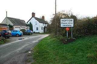
Hopton is a village in the civil parish of Hopton and Coton and is within the English county of Staffordshire.

References

  1. "Civil Parish 2011" . Retrieved 9 December 2015.
  2. OS Explorer Map 244: Cannock Chase & Chasewater: (1:25 000) : ISBN   0 319 46269 2
  3. "OS Explorer Map 244: Cannock Chase & Chasewater" (Ordnance Survey Website). Ordnance Survey Leisure Maps. Retrieved 15 April 2013.
  4. – Staffordshire A-Z County Atlas: 2011 Edition: Scale:3.8 inches to 1 mile (5.9 cm to 1 km) ISBN   978 1 84348 748 7
  5. 1 2 3 Staffordshire Place Names Including The Black Country – Page 63:Author: Anthony Poulton-Smith: Publisher: Countryside Books (1995): ISBN   1853063614
  6. The Domesday Book, Englands Heritage, Then and Now, Editor: Thomas Hinde, Staffordshire Section: ISBN   1858334403
  7. "Hixon". Open Domesday. Archived from the original (by Anna Powell-Smith. Domesday data created by Professor J.J.N. Palmer, University of Hull.) on 5 May 2013. Retrieved 15 April 2013.
  8. 1 2 3 Details about RAF Hixon Archived 4 November 2014 at the Wayback Machine . Retrieved 16 April 2013
  9. Details about the Control Tower- RAF Hixon. Retrieved 16 April 2013
  10. Ministry of Transport (1968). Report of the Public Inquiry into the Accident at Hixon Level Crossing on 6 January 1968. HMSO. ISBN   0-10-137060-1.
  11. Listed Building schedule – Parish Church of Saint Peter. Retrieved 15 April 2013
  12. Staffordshire (The Buildings of England): Author: Nikolaus Pevsner: Publisher: Pevsner Architectural Guides; 1st edition (27 May 1976): ISBN   0140710469
  13. "A SHORT HISTORY OF ST. PETER'S CHURCH, HIXON". Mid Trent Churches.
  14. Hixon Halt Railway Station – English Heritage. Retrieved 16 April 2013
  15. "BBC Stoke article on Wilmot Martin". BBC.

Commons-logo.svg Media related to Hixon, Staffordshire at Wikimedia Commons