Sowerby is a small village, electoral ward and civil parish in the Hambleton district of North Yorkshire, England immediately south of Thirsk. The parish boundary merges with that of Thirsk, so the village could be described as a suburb. The author James Herriot lived in the village.

Mere is a small town and civil parish in Wiltshire, England. It lies at the extreme southwestern tip of Salisbury Plain, close to the borders of Somerset and Dorset. The parish includes the hamlets of Barrow Street, Burton, Charnage, Limpers Hill, Rook Street and Southbrook.

Berwick Bassett is a small village and civil parish in Wiltshire, England, about 6 miles (10 km) northwest of Marlborough and 8 miles (13 km) southwest of Swindon. The village is on the west bank of a headstream of the River Kennet and close to the A4361 road, formerly the A361, which links Devizes and Avebury with Wroughton and Swindon.

Sulgrave is a village and civil parish in South Northamptonshire, England, about 5 miles (8 km) north of Brackley. The village is just south of a stream that rises in the parish and flows east to join the River Tove, a tributary of the Great Ouse.

Leckhampstead is a village and civil parish in West Berkshire, England in the North Wessex Downs.

Brimpton is a mostly rural village and civil parish in West Berkshire, England. The village occupies a few square miles of land between the Kennet and Avon Canal, a long tributary the Enborne which is used as part of the Hampshire boundary and the winding slopes of an escarpment in the far south-east, beyond the Enborne which is almost contiguous with the larger settlement of Baughurst a wood-buffered part of Tadley post town. This high common field contains five round barrows from the period of the Heptarchy in Anglo Saxon England.

Abbots Ripton is a village and civil parish in Cambridgeshire, England. Abbots Ripton is situated within Huntingdonshire which is a non-metropolitan district of Cambridgeshire as well as being an historic county of England. Abbots Ripton lies approximately 4 miles (6 km) north of Huntingdon on the B1090.

Burcombe is a village and a civil parish in Wiltshire, England. The village is about 4.5 miles (7 km) west of Salisbury city centre and lies each side of an unclassified road. Burcombe is an unspoiled village with many of the houses' gardens leading down to the River Nadder. The parish includes the hamlet of Ugford which is on the A30 road near the boundary with Wilton parish.

Streat is a village in the Lewes district of East Sussex, England, 3 miles (4.8 km) south-east of Burgess Hill and 5 miles (8.0 km) west of Lewes, within the South Downs National Park.

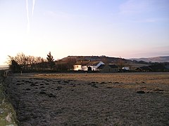
Newtimber is a small village and civil parish in the Mid Sussex District of West Sussex, England. It is located north-west of Brighton, and is named after Newtimber Place; the parish also includes the hamlet of Saddlescombe. The parish lies almost wholly with the South Downs National Park, with the exception of a small section of the parish north of the B2117 road. The planning authority for Newtimber is therefore the South Downs National Park Authority (SDNPA), the statutory planning authority for the National Park area.
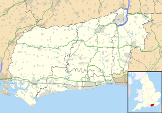
Pyecombe is a village and civil parish in the Mid Sussex District of West Sussex, England. The parish lies wholly with the South Downs National Park. The planning authority for Pyecombe is therefore the South Downs National Park Authority (SDNPA), the statutory planning authority for the National Park area.

Horningsham is a small village and civil parish in Wiltshire, England, on the county border with Somerset. The village lies about 4 miles (6 km) southwest of the town of Warminster and 4 1⁄2 miles (7 km) southeast of Frome, Somerset.

The Bull Ring is a Class II henge that was built in the late Neolithic period near Dove Holes in Derbyshire, England.

Church Lawton is a small village and located in the unitary authority of Cheshire East and the ceremonial county of Cheshire in England. Its location is such that its eastern boundary forms part of the county boundary between Cheshire and Staffordshire and, because of its close proximity to Stoke-on-Trent, the parish has a Stoke postcode. In addition to ribbon development connecting Kidsgrove with Scholar Green, the parish also contains the hamlets of Lawton Gate, Lawton Heath and Lawton Heath End, and the Lawton Hall estate. According to the 2001 census, the population of the entire parish was 2,201.
Great Chishill is a village in the civil parish of Great and Little Chishill, South Cambridgeshire, England. The village is about 1 mile (1.6 km) east of the county boundary with Hertfordshire and about 4 miles (6 km) east of Royston. The 2011 Census recorded the parish's population as 678.

Tilshead is a village and civil parish in the county of Wiltshire in Southern England, about 9 miles (14 km) northwest of the town of Amesbury. It is close to the geographical centre of Salisbury Plain, on the A360 road approximately midway between the villages of Shrewton and Market Lavington, and is near the source of the River Till. Its population in 2011 was 358, down from a peak of 989 inhabitants in 1951.

Ramsden is a village and civil parish about 3 1⁄2 miles (5.6 km) north of Witney in West Oxfordshire. The 2011 Census recorded the parish's population as 342.

The Church of St Luke, Sheen, Staffordshire is a Grade II* listed Anglican church. Its origins are of the 14th century, but it was largely rebuilt in the mid-19th century, firstly by C. W. Burleigh, and then by William Butterfield. The church, and its associated parsonage, were the last buildings recorded by Nikolaus Pevsner in his Buildings of England series, when he concluded the series in 1974 with his Staffordshire volume, finishing a project begun in 1945.
Sheen is a civil parish in the district of Staffordshire Moorlands, Staffordshire, England. It contains 37 listed buildings that are recorded in the National Heritage List for England. Of these, four are at Grade II*, the middle of the three grades, and the others are at Grade II, the lowest grade. Apart from the village of Sheen and smaller settlements, the parish is rural. Most of the listed buildings are farmhouses and farm buildings, houses and associated structures, and cottages. The other listed buildings are a church, a memorial in the churchyard, two crosses, a road bridge, the entrance to a former country house which has been demolished, a former school, and a milepost.

Harthill Moor is a small upland area in the Derbyshire Peak District of central and northern England, lying between Matlock and Bakewell near the villages of Birchover and Elton. Its highest point is 272 metres (892 ft) above sea level. The River Bradford flows along the northern edge of the moor past Youlgreave and into the River Lathkill at Alport. Harthill Moor is a rich prehistoric landscape with several protected Scheduled Ancient Monuments.