
Cherry Grove is a hamlet in the Town of Brookhaven, Suffolk County, New York, United States. It is located on Fire Island, a barrier island separated from the southern side of Long Island by the Great South Bay. The hamlet has approximately 300 houses on 41 acres (170,000 m2), a summer seasonal population of 2,000 and a year-round population of 15.
Holly Grove may refer to:
Spring Grove may refer to

Bear Rocks are a widely recognized symbol of West Virginia wilderness and among the most frequently photographed places in the state. They are a well-known landmark on the eastern edge of the plateau that includes the Dolly Sods Wilderness. They sit in a high-elevation heathland punctuated with wind-carved sandstone outcrops and is home to more than a dozen rare plant and animal species. Situated on the crest of the Allegheny Front, Bear Rocks afford vistas over the South Branch Potomac River. Visibility can extend eastward to the Shenandoah National Park in Virginia.

West Virginia Route 20 is a major north–south state highway in the U.S. state of West Virginia. The southern terminus of the route is at U.S. Route 52 in Bluewell, a small unincorporated suburb of Bluefield. The northern terminus is at West Virginia Route 7 three miles (5 km) east of New Martinsville. WV Route 20 is the longest state route in West Virginia.

Apple Grove is an unincorporated community located in McDowell County, West Virginia, United States. Apple Grove is located along West Virginia Route 80 on the Dry Fork, south of Iaeger.

James Edgar Martine was an American Democratic Party politician who served as United States Senator from New Jersey.
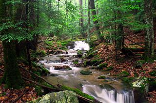
Holly River State Park is a state park located in Webster County, West Virginia. Situated on the Left Fork of the Holly River near the town of Hacker Valley, it is the second largest park in the West Virginia state park system with a total of 8,294 acres (3,356 ha). The park features over 42 miles (68 km) of hiking trails, ten vacation cabins, an 88-unit campground, and many recreation and picnic areas.

The Paint Creek–Cabin Creek Strike, or the Paint Creek Mine War, was a confrontation between striking coal miners and coal operators in Kanawha County, West Virginia, centered on the area enclosed by two streams, Paint Creek and Cabin Creek.

Elk River Wildlife Management Area is located on 18,225 acres (7,375 ha) east of Sutton in Braxton County, West Virginia. It protects lands along the Holly River and Elk River upstream of Sutton Lake.
Mount Holly is an unincorporated community in Westmoreland County, in the U. S. state of Virginia.

Holly Grove Mansion, also known as Holly Grove Inn or Ruffner Mansion, is a historic home located at Charleston, West Virginia on the grounds of the West Virginia State Capitol. It is a large brick house with a front section made to accommodate three floors and rear section housing two. It features a massive two story, semi-circular portico at the front entrance. It was constructed originally in 1815 as the home of Daniel Ruffner, one of a family which helped develop the early salt industry in the Kanawha Valley. It gained its present-day appearance in about 1902 when new owner, John Nash, undertook substantial remodeling. In 1979, the mansion underwent an extensive rehabilitation when it became headquarters for the West Virginia Commission on Aging.
The Mountain Parkway Byway and Mountain Parkway Backway are two routes in northern Webster County, West Virginia. The Byway is a state-designated scenic byway which follows West Virginia Route 20 for 9.8 miles (15.8 km), traversing the headwaters of several mountain streams including the Right Fork Little Kanawha River, Jerry Run, and the Left and Laurel Forks of Holly River. The Backway explores backroads in the same area, is 32 miles (51 km) long, and follows stretches of the Right Fork Little Kanawha River and Left Fork Holly River for portions of its route.
Holly is an unincorporated community in Kanawha County, West Virginia, United States, situated along Cabin Creek.

Spring Grove is a historic home located at Mount Holly, Westmoreland County, Virginia. It was built in 1834, and is a two-story, five-bay, brick farmhouse. The interior features pattern book inspired Greek Revival and Federal style woodwork and plasterwork. The front facade features a pedimented tetrastyle portico in an Ionic order. Also on the property are a contributing smokehouse and kitchen.
The following television stations operate on virtual channel 40 in the United States:
Holly Grove School District No. 7 was a school district headquartered in Holly Grove, Arkansas.


