Homeville, Virginia

Last updated
Homeville, Virginia
Unincorporated community

Homeville, VA.jpg

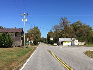
Homeville, at the intersection of Routes 35 and 40
USA Virginia location map.svg
Red pog.svg
Homeville, Virginia
Usa edcp location map.svg
Red pog.svg
Homeville, Virginia
Coordinates: 36°56′56″N77°10′17″W / 36.94889°N 77.17139°W / 36.94889; -77.17139 Coordinates: 36°56′56″N77°10′17″W / 36.94889°N 77.17139°W / 36.94889; -77.17139
Country United States
State Virginia
County Sussex
Elevation 112 ft (34 m)
Time zone Eastern (EST) (UTC-5)
  Summer (DST) EDT (UTC-4)
Area code(s) 804
GNIS feature ID 1495711 [1]

Homeville is a small unincorporated community in Sussex County, Virginia, United States. Homeville is located at the junction of Virginia State Route 35 and Virginia State Route 40 7.3 miles (11.7 km) south-southwest of Waverly.

Sussex County, Virginia County in the United States

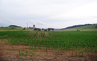
Sussex County is a rural county located in the Commonwealth of Virginia. As of the 2010 census, the population was 12,087. Its county seat is Sussex. It was formed in 1754 from Surry County. The county is named after the county of Sussex, England.

Virginia State of the United States of America

Virginia, officially the Commonwealth of Virginia, is a state in the Southeastern and Mid-Atlantic regions of the United States located between the Atlantic Coast and the Appalachian Mountains. Virginia is nicknamed the "Old Dominion" due to its status as the first English colonial possession established in mainland North America and "Mother of Presidents" because eight U.S. presidents were born there, more than any other state. The geography and climate of the Commonwealth are shaped by the Blue Ridge Mountains and the Chesapeake Bay, which provide habitat for much of its flora and fauna. The capital of the Commonwealth is Richmond; Virginia Beach is the most populous city, and Fairfax County is the most populous political subdivision. The Commonwealth's estimated population as of 2018 is over 8.5 million.

Virginia State Route 35 highway in Virginia

State Route 35 is a primary state highway in the U.S. state of Virginia. The state highway runs 48.71 miles (78.39 km) from the North Carolina state line near Boykins, where the highway continues as North Carolina Highway 35, north to SR 605 and SR 622 in Templeton. SR 35 is the main north–south highway of Southampton County; the highway also connects U.S. Route 58 in Courtland with Interstate 95 (I-95) and US 301 at Templeton south of Petersburg.
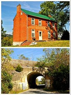
Chester Plantation

Chester, purchased by Captain William Harrison (1747-1822) in 1787, and fought in the American Revolution is located near Homeville. Chester is noteworthy architecturally for its huge double chimneys joined on two levels by connecting closets. Its interior woodwork has also survived. Chester is listed on the National Register of Historic Places. [2] [3]

Chester (Homeville, Virginia)

Chester is a historic home located near Homeville, Sussex County, Virginia. It was built in 1773, and is a two-story, three bay, frame dwelling with side gable roof. It features two exterior chimney stacks, joined on both the first and second floor levels by pent closets. Attached to the main section is a two-story wing with an exterior chimney and a shallow gable roof added in the 1820s.

American Revolution Colonial revolt in which the Thirteen Colonies won independence from Great Britain

The American Revolution was a colonial revolt that took place between 1765 and 1783. The American Patriots in the Thirteen Colonies won independence from Great Britain, becoming the United States of America. They defeated the British in the American Revolutionary War (1775–1783) in alliance with France and others.

National Register of Historic Places federal list of historic sites in the United States

The National Register of Historic Places (NRHP) is the United States federal government's official list of districts, sites, buildings, structures, and objects deemed worthy of preservation for their historical significance. A property listed in the National Register, or located within a National Register Historic District, may qualify for tax incentives derived from the total value of expenses incurred preserving the property.

Related Research Articles

Natural Bridge, Virginia Unincorporated community in Virginia, United States

Natural Bridge is an unincorporated community in Rockbridge County, Virginia, United States. The community is the site of Natural Bridge, a natural arch which gives the town its name. Natural Bridge is located at the junction of U.S. Route 11 and State Route 130. Natural Bridge has a post office with ZIP code 24578, which opened on June 1, 1800.

Files Crossroad, West Virginia Unincorporated community in West Virginia, United States

Files Crossroad is an unincorporated community in Berkeley County, West Virginia. The community is located east of Martinsburg on West Virginia Route 45 at its crossroads with County Route 45/4. The community was originally known as Smoketown, hence the name of its historic Smoketown Cemetery.

Jones Springs, West Virginia Unincorporated community in West Virginia, United States

Jones Springs is an unincorporated community in Berkeley County, West Virginia. It is located on County Route 7 at its junction with County Route 7/8. The town, and several of its houses, lies on top of the numerous springs that give the community its name.

Quinton, Virginia Unincorporated community in Virginia, United States

Quinton is a small unincorporated community in New Kent County, Virginia, United States. It is located on State Route 249 in the western portion of the county.

Dailey, West Virginia Census-designated place (CDP) in West Virginia, United States

Dailey is a census-designated place (CDP) in Randolph County, West Virginia, United States. Dailey is located on U.S. Route 219 and U.S. Route 250 3 miles (4.8 km) south-southwest of Beverly. Dailey has a post office with ZIP code 26259. As of the 2010 census, its population was 114.

Newport, Augusta County, Virginia Unincorporated community in Virginia, United States

Newport is an unincorporated community in Augusta County, Virginia, United States. Newport is located on Virginia State Route 252 7 miles (11 km) southeast of Craigsville.

Spring Grove, Virginia Unincorporated community in Virginia, United States

Spring Grove is an unincorporated community in Surry County, Virginia, United States. Spring Grove is located at the junction of Virginia State Route 10 and Virginia State Route 40 7.9 miles (12.7 km) west-northwest of Surry. Spring Grove has a post office with ZIP code 23881.

Glade Hill, Virginia Unincorporated community in Virginia, United States

Glade Hill is an unincorporated community in Franklin County, Virginia, United States. Glade Hill is located on Virginia State Route 40 7.2 miles (11.6 km) east of Rocky Mount. Glade Hill has a post office with ZIP code 24092, which opened on April 1, 1837.

Littleton, Virginia Unincorporated community in Virginia, United States

Littleton is an unincorporated community in Sussex County, Virginia, United States. Littleton is located on Virginia State Route 35 9.7 miles (15.6 km) south-southwest of Waverly.

Wagontown, Pennsylvania Unincorporated community in Pennsylvania, United States

Wagontown is an unincorporated community in West Caln Township, Chester County, Pennsylvania, United States. Wagontown is located along Pennsylvania Route 340 2.15 miles (3.46 km) north-northwest of Coatesville. Wagontown has a post office with ZIP code 19376. The Hibernia House, which is listed on the National Register of Historic Places, is located near Wagontown.

Cabin Point, Virginia Unincorporated community in Virginia, United States

Cabin Point is an unincorporated community in Surry County, Virginia, United States. Cabin Point is located on Virginia State Route 10 4.8 miles (7.7 km) southwest of Claremont. Montpelier, a home which is listed on the National Register of Historic Places, is located near Cabin Point.

Vernon Hill, Virginia Unincorporated community in Virginia, United States

Vernon Hill is an unincorporated community in Halifax County, Virginia, United States. Vernon Hill is located on Virginia State Route 360 9.7 miles (15.6 km) west of Halifax. Vernon Hill has a post office with ZIP code 24597, which opened on September 8, 1856.

Mossy Creek, Virginia Unincorporated community in Virginia, United States

Mossy Creek is an unincorporated community in Augusta County, Virginia, United States. Mossy Creek is located on Virginia State Route 42 3.3 miles (5.3 km) west-southwest of Bridgewater. The Hannah Miller House and the Henry Miller House, which are listed on the National Register of Historic Places, are both located near Mossy Creek.

Summerdean, Virginia Unincorporated community in Virginia, United States

Summerdean is an unincorporated community in Augusta County, Virginia, United States. Summerdean is located at the junction of State Routes 602 and 603 11.3 miles (18.2 km) west-southwest of Staunton. The Glebe Schoolhouse, which is listed on the National Register of Historic Places, is located near Summerdean.

New Ellett, Virginia Unincorporated community in Virginia, United States

New Ellett is an unincorporated community in Montgomery County, Virginia, United States. New Ellett is located on State Route 723 3.5 miles (5.6 km) southeast of Blacksburg.

Alleghany Springs, Virginia Unincorporated community in Virginia, United States

Alleghany Springs is an unincorporated community in Montgomery County, Virginia, United States. Alleghany Springs is located along State Route 637 7.9 miles (12.7 km) east of Christiansburg.

Piedmont, Montgomery County, Virginia Unincorporated community in Virginia, United States

Piedmont is an unincorporated community in Montgomery County, Virginia, United States. Piedmont is located on State Route 653 10.7 miles (17.2 km) east-southeast of Christiansburg.

Brush Harbor, Virginia Unincorporated community in Virginia, United States

Brush Harbor is an unincorporated community in Montgomery County, Virginia, United States. Brush Harbor is located along State Route 636 7.5 miles (12.1 km) east-northeast of Christiansburg.

Basham, Virginia Unincorporated community in Virginia, United States

Basham is an unincorporated community in Montgomery County, Virginia, United States. Basham is located at the junction of State Routes 615 and 726, 7.4 miles (11.9 km) south-southeast of Christiansburg.

References