Hongcheon County

Last updated
Hongcheon
홍천군
Korean transcription(s)
   Hangul 홍천군
   Hanja
  Revised RomanizationHongcheon-gun
  McCune-ReischauerHongch'ŏn-gun
Hongcheon-gun office.JPG
Hongcheon County Office
Flag of Hongcheon.svg
Hongcheon logo.png
Gangwon-Hongcheon.svg
Location in South Korea
CountryFlag of South Korea.svg  South Korea
Region Gwandong
Administrative divisions 1 eup, 9 myeon
Area
  Total1,817.9 km2 (701.9 sq mi)
Population
 (2020)
  Total68,389
  Dialect
Gangwon

Hongcheon (Hongcheon-gun) is a county and city in Gangwon Province, South Korea. The city lies on the northern bank of the Hongcheon River, southeast of Chuncheon. The terrain of the county is mainly mountainous and contains hot springs in the Hongcheong River valley. [1] [2] The county produces ginseng, maize, and vegetables. As of 2012 the county had a population of 70,401 people (including foreigners) in 29,894 households. [3]

Contents

History

Hongcheon's historic name was BulRyeokChunHyeon during the rule of Goguryeo. King Gyeongduk of Silla changed the name to YoungHyeon of Sak-Ju, In 1043, it was named Hongcheon during the reign of King In-Jong. Following the independence of the country on 15 August 1945, many administrative changes were made, affecting the jurisdiction of various units under its control. [4]

Korean Federation for Environmental Movement (KFEM) opened an educational facility in Hongcheon in 1995. [5]

Hongcheon County uses an emblem to represent itself as the “County of Culture and Tourism.” The emblem, a simple depiction of a leaf and dew, symbolizes a clean environment, patriotism, and love of one's hometown. [6]

Geography

The Hongcheon dam on the Hongcheon River. Hongcheon IMG 2530.JPG
The Hongcheon dam on the Hongcheon River.

Hongcheon is located in Gangwon Province. The county, located in the middle of the peninsula, is the largest in Korea with an area of about 1,818 square kilometres (702 sq mi) and is reported to be three times the size of Seoul. It is bounded by Chuncheon city on the north, the Inje County and Yangyang County to the northeast, by Gapyeong County of Gyeonggi Province to the west, by Hoengseong and Pyeongchang counties to the north, and Pyeongchang county to the south. The county is a middle-level mountainous region, an offshoot of the Baegdu mountain range. [7] The eastern end of the mountain range, where Myeonggae village and Nae township are located, runs in an east–west direction for a length of 93.1 km (57.8 mi) The western part of the mountain range which has Dongmak village and Seotown extends over a length of 39.4 km (24.5 mi) in an east–west direction. While the southern part of the hill range covers the Sidong village and the Nam town, the northern part has Jangnam village and Duchon township. [7] The Palbong Mountain (327.4 m) has scenic views of the course of the Hongcheon River; the river forms white sandy banks. [8] The Hongcheon river system which rises the Taebaek mountain watershed, joins the Hongcheon River which forms a small plain area at Seorak-myeon, Gapyeong-gun, Gyeonggi-do. It then flows in to the Cheongpyeong Dam in Gyeonggi Province. [7] [9] Gachilbong Sambong Spring is located in Gwangwon-ri, Nae-myeon and originates from the Palbong Mountain; [10] Garyeong Waterfall is located in Waya-ri, Naechon-myeon at the foot of Mt. Baekam (1,099m) which drops through rapids over a height of 50 m. The area is known for medicinal herbs, wild flowers and mountain birds. [11]

The bus terminal provides connections with Gimpo and Incheon airports. [12] A bus ride from Dong Seoul Bus Terminal to Hongcheon is approximately one hour. [13] Naerincheon, a small river, crosses Hongcheon and is the only one in the country which flows north. [14] Nearby is the Daemyung Vivaldi Park Ski World, a ski resort (with 13 ski runs, each with a music theme) [15] and water park called OceanWorld in the mountains. Local football club Hongcheon Idu FC play their games at Hongcheon Public Park.

One of the attractions of Hongcheon is Alpaca World. Located in the forest of Pungcheon-ri, Hwachon-myeon, Hongcheon-gun, this place is designed to provide communication and experience with animals. It is popular with people because they can meet various animals as well as alpacas. [16]

Climate

The climate of Hongcheon County is a humid continental climate (Köppen: Dwa). Climatic conditions are considered extreme as its location is away from the sea. The minimum temperature recorded is –28.1 °C in January. The climatic data is given in the table below. On 1 August 2018, Hongcheon County recorded a temperature of 41.0 °C (105.8 °F), which is the highest temperature to have ever been recorded in South Korea. [17]

Climate data for Hongcheon (1991–2020 normals, extremes 1971–present)
MonthJanFebMarAprMayJunJulAugSepOctNovDecYear
Record high °C (°F)14.1
(57.4)
20.1
(68.2)
23.9
(75.0)
32.5
(90.5)
35.0
(95.0)
36.2
(97.2)
38.5
(101.3)
41.0
(105.8)
34.5
(94.1)
29.1
(84.4)
25.6
(78.1)
16.7
(62.1)
41.0
(105.8)
Mean daily maximum °C (°F)2.1
(35.8)
5.4
(41.7)
11.7
(53.1)
19.1
(66.4)
24.5
(76.1)
28.4
(83.1)
29.8
(85.6)
30.4
(86.7)
26.0
(78.8)
20.0
(68.0)
11.5
(52.7)
3.7
(38.7)
17.7
(63.9)
Daily mean °C (°F)−4.8
(23.4)
−1.7
(28.9)
4.4
(39.9)
11.2
(52.2)
16.9
(62.4)
21.6
(70.9)
24.5
(76.1)
24.7
(76.5)
19.2
(66.6)
12.0
(53.6)
4.6
(40.3)
−2.6
(27.3)
10.8
(51.4)
Mean daily minimum °C (°F)−10.5
(13.1)
−7.7
(18.1)
−2.0
(28.4)
3.8
(38.8)
10.0
(50.0)
16.0
(60.8)
20.5
(68.9)
20.6
(69.1)
14.5
(58.1)
6.6
(43.9)
−0.6
(30.9)
−7.6
(18.3)
5.3
(41.5)
Record low °C (°F)−28.1
(−18.6)
−24.8
(−12.6)
−16.8
(1.8)
−8.0
(17.6)
0.2
(32.4)
4.7
(40.5)
9.9
(49.8)
8.5
(47.3)
0.4
(32.7)
−6.4
(20.5)
−14.7
(5.5)
−22.8
(−9.0)
−28.1
(−18.6)
Average precipitation mm (inches)15.8
(0.62)
26.2
(1.03)
36.7
(1.44)
74.8
(2.94)
101.3
(3.99)
124.9
(4.92)
395.7
(15.58)
312.5
(12.30)
141.3
(5.56)
49.7
(1.96)
40.9
(1.61)
19.1
(0.75)
1,338.9
(52.71)
Average precipitation days (≥ 0.1 mm)5.25.67.48.18.39.515.214.48.55.57.36.5101.5
Average snowy days7.45.73.60.40.00.00.00.00.00.12.15.724.7
Average relative humidity (%)65.861.958.055.560.866.076.075.974.572.069.168.167.0
Mean monthly sunshine hours 163.8169.9196.8209.2228.9205.8150.6168.0170.4175.9144.7150.02,134
Percent possible sunshine 52.655.452.854.351.146.235.541.747.152.547.850.448.6
Source: Korea Meteorological Administration (snow and percent sunshine 1981–2010) [18] [19] [20]

Flora and fauna

Blooming Azalea, the county flower Korea-Spring in Andong-Blooming azalea-01.jpg
Blooming Azalea, the county flower

Daisy fleabane, a native plant of North America, was inadvertently introduced to Korea in the 1990s and is found in Hongcheon County also. A strange spot on its leaf was found in daisy fleabanes in June 2011. This was tested in the laboratory and found to be caused by a pest identified as Septoria erigerontis . [21]

Rice cultivation

The dominant crop grown in the country is called the Sura rice. The county, with its widely varying temperatures between day and night times, and with clean and un polluted water, provides an ideal environmental condition ideal to grow this crop which is considered to be of very high quality with cooked rice retaining its taste for much longer than other species of rice. It is grown in 38% of the land under cultivation in the county. It is also disease resistant and can be stored for a long time. [22]

Culture

The county is noted for its beef production with its climatic conditions favorable for raising male calves (bred by artificial insemination) which are bred for their exquisite flavor and texture. They are fed alcohol-fermented feed which is reported to reduce the cholesterol content and give flavor to the beef. The calves are raised for minimum of 27 months. [23]

Cultural festivals celebrated in Hongcheon include the Chal Oksusu (Corn) Festival, Mugunghwa (Hibiscus) Festival, and Ginseng Festival. [24] The Mugunghwa Festival honors the memory of Namgung Eok, a statesman and journalist from Hongcheon. [25] The Hongcheon Ginseng Festival, first held in 2003, is held annually in October to celebrate the medicinal properties of ginseng, considered a miracle medicine in Korea. Traditional Taekkyeon and Dudrak performances are part of the festivities. [13] [26] Previously, the county celebrated Choi Seung-hee Dance Festival in honor of a dancer who developed modern forms of traditional folk dances, but because she spent the latter years of her life in North Korea, she is no longer celebrated.

Symbol Mark

Among the five colors of Mugunghwa petals, blue symbolizes the spirit of the county people, green symbolizes the unpolluted natural environment. Pink symbolizes the fragrance of flowers. Yellow symbolizes the peace of Hongcheon. Red symbolizes the passion of Hongcheon.

Hongcheon logo.png

The center of the flower represents the cohesive power of the Hongcheon people and the green water droplets in the lower part represent a clean earth.

Character

The name of the character is Mugung-gi (literally Eternal-flag) - a symbol of Hongcheon with MugungHwa (literally Eternal Flower) central to its design incorporating other elements.

The water droplets representing the nature of Hongcheon were expressed to the face. The high-tech antenna on the right expressed its meaning as a character leading the information age. [27]

Notable sites

The Korean peninsula has been subject to archaeological excavations for establishing obsidian (a naturally occurring volcanic glass formed as an extrusive igneous rock) at many Paleolithic sites. One such site excavated is located in Hongcheon county, known as Hahwageri III. Several samples collected from the site have been subject to carbon dating. In the first cultural layer, out of the two layers established during the excavations, the finds consists of microliths of obsidian and quartz crystal which are embedded in microblade cores. In addition, arrowheads, cores, anvils, hammerstones and pecking tools have also been recovered, apart from a large cache of obsidian artifacts. [28]

The Suta Temple of Mt Gongjak is a Buddhist shrine at the foot of the Gongjak Mountain which appears like a peacock spreading its wings and its flora consists of azalea and ancient pine trees. It is a national monument that was built in 708, in stone, by the Buddhist priest WonHyo during the reign of King SeongDeok, the 33rd King of Silla. [29]

Notable people

It is the birthplace of Lee Young-Pyo, who gained global recognition as the legendary leftback of the 2002 South Korea national football team which reached the semifinal of 2002 World Cup, and went on to play for various top tier teams in Europe such as Tottenham Hotspur and PSV Eindhoven to great acclaim.

Related Research Articles

<span class="mw-page-title-main">Gangneung</span> Municipal City in Gwandong, South Korea

Gangneung is a municipal city in Gangwon State, on the east coast of South Korea. It has a population of 213,658. Gangneung is the economic centre of the Yeongdong region of Gangwon State. It has many tourist attractions, such as Jeongdongjin, a very popular area for watching the sunrise, and Gyeongpo Beach. The city hosted all the ice events for the 2018 Winter Olympics and the 2024 Winter Youth Olympics.

<span class="mw-page-title-main">Gangwon Province, South Korea</span> Province of South Korea

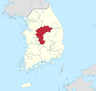
Gangwon State is a Special Self-Governing Province of South Korea and the least densely populated subdivision of the country. Gangwon is one of the three provinces with special self-governing status, the others being Jeju Province and Jeonbuk State. On the east bound by the East Sea, it borders Gyeonggi Province to its west, North Gyeongsang Province and North Chungcheong Province to its south, and the Military Demarcation Line to the north, separating it from North Korea's Kangwŏn Province. Before the division of Korea in 1945 Gangwon and Kangwŏn Provinces formed a single province.

<span class="mw-page-title-main">North Chungcheong Province</span> Province of South Korea

North Chungcheong Province, also known as Chungbuk, is a province of South Korea. North Chungcheong has a population of 1,578,934 (2014) and has a geographic area of 7,433 km2 (2,870 sq mi) located in the Hoseo region in the south-center of the Korean Peninsula. North Chungcheong borders the provinces of Gyeonggi and Gangwon to the north, North Gyeongsang to the east, North Jeolla to the south and South Chungcheong, Sejong Special Autonomous City and Daejeon Metropolitan City to the west.

<span class="mw-page-title-main">Samcheok</span> Municipal City in Gangwon, South Korea

Samcheok is a city in Gangwon-do, South Korea.

<span class="mw-page-title-main">Inje County</span> County in Gwandong, South Korea

Inje County is a county in Gangwon Province, South Korea. It has the lowest population density of any South Korean county. The county seat is Inje-eup, which located near the center of the county.

<span class="mw-page-title-main">Namwon</span> Municipal City in Honam, South Korea

Namwon is a city in North Jeolla Province, South Korea. Namwon is about 50 minutes from the provincial capital of Jeonju, which is almost three hours away from Seoul. The official city flower is Royal Azalea (철쭉) while the city tree is the crape-myrtle (배롱나무) and the city bird is the swallow (제비). Namwon is a small city located just outside Jirisan National Park, which has the largest set of mountains on the South Korean Mainland. It also borders the Seomjin River, one of South Korea's more prominent rivers. It is 3 hours and 15 minutes from the Seoul Central City Bus Terminal and about one hour from both the U-Square Bus Terminal in Gwangju and the Jeonju Inter City Bus Terminal. It is called "the City of Love" because of the famous Korean love story of Chunhyang. Gwanghanlu Garden is a shrine to this love story.

<span class="mw-page-title-main">Chuncheon</span> Municipal City in Gangwon, South Korea

Chuncheon, formerly romanized as Ch'unch'ŏn, is the capital of Gangwon Province in South Korea. The city lies in the north of the county, located in a basin formed by the Soyang River and Han River. There are some large lakes around the city, most notably Soyang Lake and Uiam Lake. The area has small river islands, such as Sangjungdo, Ha-Jungdo, Bungeodo, and Wido.

<span class="mw-page-title-main">Gapyeong County</span> County in Sudogwon, South Korea

Gapyeong County (Korean: 가평군) is a county in Gyeonggi Province, South Korea. It was the scene of the Battle of Kapyong, a major battle of the Korean War.

South Korea is made up of 22 first-tier administrative divisions: 6 metropolitan cities, 1 special city, 1 special self-governing city, and 14 provinces, including three special self-governing provinces and five claimed by the ROK government. These are further subdivided into a variety of smaller entities, including cities, counties, districts, towns, townships, neighborhoods and villages.

<span class="mw-page-title-main">Namyangju</span> City in Gyeonggi Province, South Korea

Namyangju is a city in Gyeonggi Province, South Korea. To the east is Gapyeong County, to the west is Guri City, and to the north is Pocheon City. Namyangju-si was originally a southern part of Yangju-gun, but was separated into Namyangju-gun in April 1980. In 1995, Migeum-si and Namyangju-gun were merged to form an urban and rural complex. The city hall is located in Geumgok-dong and Dasan-dong, and the administrative districts are 6-eup, 3-myeon, and 7-dong.

<span class="mw-page-title-main">Paju</span> Municipal city in Gyeonggi Province, South Korea

Paju is a city in Gyeonggi Province, South Korea. Paju was made a city in 1997; it had previously been a county (gun).

<span class="mw-page-title-main">Pocheon</span> Municipal City in Gyeonggi Province, South Korea

Pocheon (Korean pronunciation:[pʰo.tsʰʌn]) is an inland city in the far northeastern region of Gyeonggi province in South Korea. It covers 826.48 km (513.55 mi)2 with a population of 160,176 people, according to the 2008 census. Pocheon lies between Seoul and the mountainous northwestern areas of Gangwon province. The city borders Yeoncheon county, with the cities of Dongducheon and Yangju to the west, along with Uijeongbu, and Namyangju of Gyeonggi province to the south. It also borders Hwacheon county of Gangwon province on its eastern border and Cheorwon is to the north. Alongside the adjoining Gapyeong, Pocheon consists of the highest mountainous areas in Gyeonggi province. The current city of Pocheon was created after Pocheon-hyeon and Yeongpyeong counties were merged. The north part of the city used to be part of Yeongpyeong county while the south used to be part of Pocheon-hyeon.

<span class="mw-page-title-main">Yeoju</span> Municipal city in Gyeonggi Province, South Korea

Yeoju is a city in Gyeonggi Province, South Korea. Yeoju was a county but was raised to the status of a city in September 2013. Together with the neighboring city of Icheon, it is known as a major center of contemporary South Korean ceramics, and hosts the World Ceramic Exposition every year. Other local products of note include rice, sweet potatoes, and yellow melons. Yeoju is the birthplace of Korea's last queen, Empress Myeongseong.

<span class="mw-page-title-main">Geumsan County</span> County in South Chungcheong Province, South Korea

Geumsan County is a county in South Chungcheong Province, South Korea. It borders Muju County, North Jeolla Province (Jeollabuk-do), which is famous for its ski resort nearby.

<span class="mw-page-title-main">Jogye Order</span> Korean Buddhist order

The Jogye Order, officially the Jogye Order of Korean Buddhism, is the representative order of traditional Korean Buddhism with roots that date back 1200 years to the Later Silla National Master Doui, who brought Seon and the practice taught by the Sixth Patriarch, Huineng, from China around 820 CE. The name of the Order, Jogye, was adopted from the name of the village where Patriarch Huineng's home temple, Nanhua Temple, is located,.

<span class="mw-page-title-main">Yongpyong Resort</span> Ski resort in South Korea

Yongpyong Ski Resort is a ski resort in South Korea, located in Daegwallyeong-myeon, Pyeongchang, Gangwon Province. It is the largest ski and snowboard resort in Korea, and offers golf in the summer months.

Korea Hydro & Nuclear Power is a subsidiary of the Korea Electric Power Corporation (KEPCO). It operates large nuclear and hydroelectric plants in South Korea, which are responsible for about 27 percent of the country's electric power.

<span class="mw-page-title-main">Jungnang District</span> Autonomous district in Seoul, South Korea

Jungnang District (Jungnang-gu) is one of the 25 gu, or districts, of Seoul, South Korea. It is located on the north side of the Han River.

<span class="mw-page-title-main">Gulbongsan Station</span>

Gulbongsan Station is a railway station on the Gyeongchun Line in Namsan-myeon, Chuncheon-si, Gangwon-do, South Korea. Its station subname is Jade Garden where Jade Garden is located about 4 km away from the station, and a free shuttle bus runs every hour.

Galgisan (Korean: 갈기산) is a mountain located in Yangpyeong County, Gyeonggi Province, and Hongcheon County, Gangwon Province, South Korea. It has an elevation of 685 m (2,247 ft).

References

  1. Yŏn, Ha-chʻŏng (1981). Primary health care in Korea: an approach to evaluation. Korea Development Institute. p. 41. ISBN   978-0-8248-0763-4 . Retrieved 10 June 2013.
  2. Korea Now. The Korea Herald. January 2003. p. 47. Retrieved 10 June 2013.
  3. "Population". Website of Gangwon Province. 31 December 2012. Archived from the original on 2 June 2013. Retrieved 23 June 2013.
  4. "The history of hongcheon - gun". Official website of Hongcheon Gangwon. Archived from the original on 1 August 2012. Retrieved 13 June 2013.
  5. Lee, Yok-Shiu F.; So, Alvin Y. (January 1999). Asia's Environmental Movements: Comparative Perspectives. M.E. Sharpe. p. 111. ISBN   978-1-56324-909-9 . Retrieved 10 June 2013.
  6. "County Flag". Official website of Hongcheon Gangwon. Archived from the original on 1 August 2012. Retrieved 23 June 2013.
  7. 1 2 3 "General". Official website of Hongcheon Gangwon. Archived from the original on 27 February 2014. Retrieved 13 June 2013.
  8. "1st Spot : Palbong-san Mountain". Official website of Hongcheon Gangwon. Archived from the original on 4 August 2012. Retrieved 13 June 2013.
  9. Ahn, Y.K.; Ryan, Y.S. (September 1988). "Epidemiological studies on Metagonimus infection along the Hongcheon river, Kangwon province". Kisaengchunghak Chapchi. 26 (3): 207–213. doi:10.3347/kjp.1988.26.3.207. PMID   12811049.
  10. "Gachilbong Sambong Spring". Official website of Hongcheon Gangwon. Archived from the original on 1 August 2012. Retrieved 13 June 2013.
  11. "Garyeong Waterfall". Official website of Hongcheon Gangwon. Archived from the original on 2 August 2012. Retrieved 13 June 2013.
  12. "Hongcheon Bus Schedules".
  13. 1 2 "Hongcheon Ginseng Festival". Korea Tourism Organization.
  14. Frommer's Short Cuts (27 June 2012). Gangwon-do, South Korea: Frommer's ShortCuts. John Wiley & Sons. pp. 77–. ISBN   978-1-118-47010-7.
  15. Kendall Hamilton, ed. (November 2005). Ski. pp. 182–. ISSN   0037-6159.
  16. 최, 영재. "[홍천]홍천 알파카월드 언택트 관광지 주목". 강원일보 홈페이지 (in Korean). Retrieved 2021-05-01.
  17. "한반도 폭염 신기원…서울 39.6도·홍천 41.0도". news1 . Retrieved 1 August 2018.
  18. "Climatological Normals of Korea (1991 ~ 2020)" (PDF) (in Korean). Korea Meteorological Administration. Archived from the original (PDF) on 29 January 2022. Retrieved 4 April 2022.
  19. 순위값 - 구역별조회 (in Korean). Korea Meteorological Administration. Retrieved 4 April 2022.
  20. "Climatological Normals of Korea" (PDF). Korea Meteorological Administration. 2011. Archived from the original (PDF) on 7 December 2016. Retrieved 8 December 2016.
  21. Park, J. H.; Han, K. S.; Hong, S. H.; Shin, H. D. (2012). "First Report of Leaf Spot Caused by Septoria erigerontis on Erigeron strigosus in Korea" (pdf). Plant Disease (in Korean). 96 (12). Journal of the American Phytopathological Society: 1827. doi:10.1094/PDIS-08-12-0755-PDN . Retrieved 12 June 2013.
  22. "Surassal:Distinctive Features". Official website of Hongcheon Gangwon. Archived from the original on 24 June 2013. Retrieved 23 June 2013.
  23. "2013 National Brand Awards Winners". Agrafood.co.kr. Archived from the original on 11 March 2016. Retrieved 11 June 2013.
  24. "Culturafestival". Official website of Hongcheon Gangwon. Archived from the original on 30 June 2010. Retrieved 13 June 2013.
  25. "Mugunghwa Festival". Official website of Hongcheon Gangwon. Archived from the original on 16 June 2013. Retrieved 13 June 2013.
  26. "Ginseng Festival". Official website of Hongcheon Gangwon. Archived from the original on 3 August 2012. Retrieved 13 June 2013.
  27. "캐릭터 - 홍천군청". www.hongcheon.gangwon.kr. Retrieved 2019-03-16.
  28. "Pixe Provenancing Of Obsidian Artefacts From Paleolithic Sites In Korea". Ejournal of the Kangwon National University. Archived from the original on 16 May 2013. Retrieved 11 June 2013.
  29. "Suta Temple of Gongjak Mt". Official website of Hongcheon Gangwon. Archived from the original on 2 August 2012. Retrieved 13 June 2013.

37°41′33″N127°52′48″E / 37.69250°N 127.88000°E / 37.69250; 127.88000