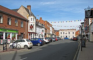
Shipston-on-Stour is a town and civil parish in the Stratford-on-Avon District and is the main settlement of the southern corner of Warwickshire, England. The compactly formed town and its associated land occupy the left bank of the River Stour 9 miles (15 km) south-south-east of Stratford-upon-Avon and 14 miles (22 km) south of Warwick. In 2011 Shipston-on-Stour had a population of 5,038.
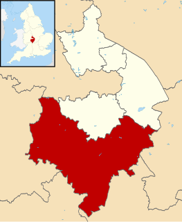
Stratford-on-Avon is a local government district in southern Warwickshire, England.

Loxley, Warwickshire, is a village and civil parish near Stratford-upon-Avon, Warwickshire, England. The population taken at the 2011 census was 399. Loxley gave its name to a hall of residence at the University of Warwick, within the Westwood campus.
Alderminster is a village and civil parish on the River Stour about 4 miles (6.4 km) south of Stratford-upon-Avon in Warwickshire, England. The village is on the A3400 road between Stratford-upon-Avon and Shipston-on-Stour. The 2011 Census recorded the parish's population as 491.

Atherstone on Stour is a small village and civil parish about 2+1⁄2 miles (4 km) south of Stratford-upon-Avon in Warwickshire, England. The 2011 Census recorded the parish's population as 59.

Barcheston is a village and civil parish in the Stratford-on-Avon district of Warwickshire, England. The village is on the east bank of the River Stour, opposite Shipston-on-Stour. It shares a parish council with Willington. The parish, administered at its lowest level by the Barcheston and Willington Parish Meeting, is in the Ettington ward of the district council. According to the 2001 Census the parishes population was 134, increasing to 141 at the 2011 Census.

Whichford is a village and civil parish in Warwickshire, England, about 5 miles (8 km) southeast of Shipston-on-Stour. The parish adjoins the county boundary with Oxfordshire and the village is about 4+1⁄2 miles (7 km) north of the Oxfordshire town of Chipping Norton. The parish includes the hamlet of Ascott, about 1⁄2 mile (800 m) east of Whichford village. The 2011 Census recorded the parish's population as 336.

Eathorpe is a small village and civil parish five miles east of Leamington Spa, in Warwickshire, England. The parish is part of the electoral ward of Cubbington. It is close to the B4455, which follows the line of the Roman Fosse Way, and the River Leam. According to the 2001 census, the parish had a population of 113, increasing to 190 at the 2011 census.
Whitchurch is a parish and a small hamlet lying on the left bank of the River Stour in Warwickshire, England, some four miles south-south-east of the town of Stratford-upon-Avon.

Ettington is a village and civil parish about 5.5 miles (9 km) south-east of Stratford-upon-Avon in Warwickshire, England. The 2011 Census recorded the parish's population as 1,171.

Cherington is a village and civil parish beside the River Stour about 3 miles (5 km) southeast of Shipston-on-Stour. Cherington is contiguous with the village of Stourton.

Moreton Morrell is a village and civil parish in the county of Warwickshire, England. It is part of the historic hundred of Kington and is located about three and a half miles north west of the village of Kineton. The settlement was first mentioned in the Domesday Book as Moreton. From at least Norman times, it has consisted of the village of Moreton and the hamlet of Morrell. The parish of Moreton Morrell is bounded on the east and south east by the Fosse Way, and consists of Little Morrell in the north, the village of Moreton Morrell, and Moreton Paddox in the south.

Preston on Stour is a village and civil parish in Warwickshire, England.

Great Wolford is a village and civil parish at the bottom of a hill in the Stratford-on-Avon district of Warwickshire, England. With the neighbouring parish of Little Wolford it is part of 'The Wolfords'.
Tredington is a village and civil parish on the River Stour in Warwickshire, England. The village is 2 miles (3 km) north of Shipston-on-Stour. The civil parish includes the village of Newbold on Stour and hamlets of Armscote, Blackwell and Darlingscott. The 2011 Census recorded the parish population as 1,422. Tredington civil parish was part of Worcestershire until 1931. The River Stour runs through Tredington, and it was here that Geoff Crabtree caught the second largest pike ever to have been netted in the United Kingdom, weighing in at 45 lb 7oz (20.6 kg), as reported in the July 2007 edition of Angler's Mail.

Stretton-on-Fosse is a village in the Stratford District in Warwickshire, England. It is situated between the towns of Moreton-in-Marsh and Shipston-on-Stour. The village is situated along the ancient Fosse Way road which runs from Exeter in Devon to Lincoln in Lincolnshire. The road bypasses the village to the east and is now the modern-day A439 road. The village is close to the Gloucestershire and Warwickshire border.

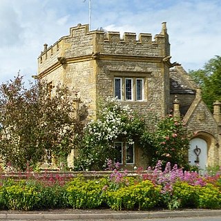
Idlicote is a small settlement and civil parish in the English county of Warwickshire, about 3 miles (5 km) north-east of Shipston-on-Stour and 8 miles (13 km) south-east of Stratford-upon-Avon. Population details can be found under Honington. The best known feature is Idlicote House, a grade II listed country house, on a site once owned by St Mary's Abbey. The most notable building is the parish church of Saint James the Great, which has surviving features from the 13th and 14th centuries and a 17th-century chapel added to house tombs of members of the Underhill family of Idlicote.

Milcote is a village and former civil parish in Warwickshire. It falls within the ecclesiastical parish of All Saints Church, Weston-on-Avon. It was made up of Upper Milcote or Milcote-on-Stour, site of Mount Grevill manor, and Lower Milcote or Milcote-on-Avon.

Tidmington is a village and civil parish in the Stratford-on-Avon District of Warwickshire, England. It is 11 miles (18 km) south from the town of Stratford-upon-Avon, and at the extreme southern edge of the county bordering Gloucestershire. Within the parish is the Grade II* listed c.1600 Tidmington House, and the Grade II* early 13th-century church of unknown dedication.
Little Wolford is a hamlet and civil parish in the Stratford-on-Avon district of Warwickshire, England. With the neighbouring parish of Great Wolford it is part of 'The Wolfords'. Little Wolford is significant for its Grade II* listed 15th- to 16th-century Little Wolford Manor House.

