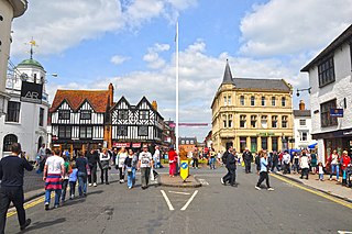
Stratford-upon-Avon, commonly known as just Stratford, is a market town and civil parish in the Stratford-on-Avon district, in the county of Warwickshire, in the West Midlands region of England. It is situated on the River Avon, 91 miles (146 km) north-west of London, 22 miles (35 km) south-east of Birmingham and 8 miles (13 km) south-west of Warwick. The town is the southernmost point of the Arden area on the edge of the Cotswolds. In the 2021 census Stratford had a population of 30,495.
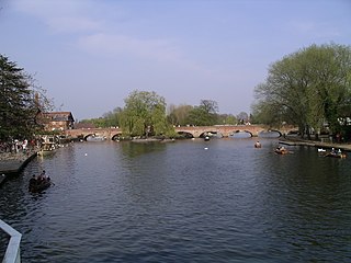
The River Avon in central England flows generally southwestwards and is a major left-bank and easternmost tributary of the River Severn. It is also known as the Warwickshire Avon or Shakespeare's Avon, to distinguish it from several other rivers of the same name in the United Kingdom.
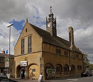
Moreton-in-Marsh is a market town in the Evenlode Valley, within the Cotswolds district and Area of Outstanding Natural Beauty in Gloucestershire, England.
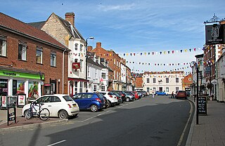
Shipston-on-Stour is a town and civil parish in the Stratford-on-Avon District in southern Warwickshire, England. It is located on the banks of the River Stour, 9 miles (15 km) south-southeast of Stratford-upon-Avon, 10 miles north-northwest of Chipping Norton, 14 miles (22 km) south of Warwick and 14.5 miles west of Banbury. In the 2021 census, Shipston-on-Stour had a population of 5,849.

Warwickshire is a ceremonial county in the West Midlands of England. It is bordered by Staffordshire and Leicestershire to the north, Northamptonshire to the east, Oxfordshire and Gloucestershire to the south, and Worcestershire and the West Midlands county to the west. The largest settlement is Nuneaton and the county town is Warwick.

Stratford-on-Avon is a local government district in Warwickshire, England. The district is named after its largest town of Stratford-upon-Avon, but with a change of preposition; the town uses "upon" and the district uses "on". The council is based in Stratford-upon-Avon and the district, which is predominantly rural, also includes the towns of Alcester, Shipston-on-Stour and Southam, and the large villages of Bidford-on-Avon, Studley and Wellesbourne, plus numerous other smaller villages and hamlets and surrounding rural areas. The district covers the more sparsely populated southern part of Warwickshire, and contains nearly half the county's area. The district includes part of the Cotswolds, a designated Area of Outstanding Natural Beauty.
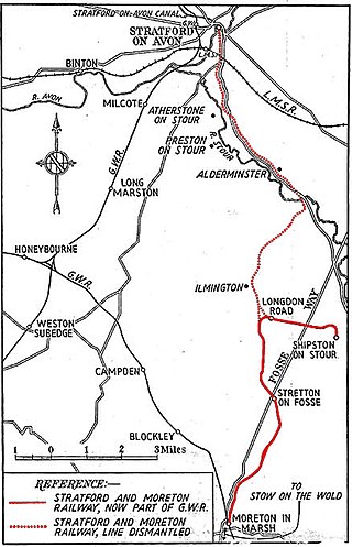
The Stratford and Moreton Tramway was a 16-mile (25-km) long horse-drawn wagonway which ran from the canal basin at Stratford-upon-Avon in Warwickshire to Moreton-in-Marsh in Gloucestershire, with a branch to Shipston-on-Stour. The main line opened in 1826, whilst the branch to Shipston opened in 1836.

Stratford-on-Avon is a constituency represented in the House of Commons of the UK Parliament since 2010 by Nadhim Zahawi, a member of the Conservative Party, who briefly served as the Chancellor of the Exchequer in mid-2022. The constituency is in Warwickshire; as its name suggests, it is centred on the town of Stratford-on-Avon, birthplace of William Shakespeare, but also takes in the surrounding areas around the town, including the towns of Alcester and Henley-in-Arden.
Alderminster is a village and civil parish on the River Stour about 4 miles (6.4 km) south of Stratford-upon-Avon in Warwickshire, England. The village is on the A3400 road between Stratford-upon-Avon and Shipston-on-Stour. The 2011 Census recorded the parish's population as 491.
Whitchurch is a parish and a small hamlet lying on the left bank of the River Stour in Warwickshire, England, some four miles south-south-east of the town of Stratford-upon-Avon.

Great Wolford is a village and civil parish in the Stratford-on-Avon district of Warwickshire, England. With the neighbouring parish of Little Wolford it is part of 'The Wolfords'.

Honington, Warwickshire is a hamlet and civil parish in the Stratford-on-Avon District of Warwickshire, England. It is in the Brailes division of the hundred of Kington, and approximately two miles north of Shipston-on-Stour. The population taken at the 2011 census was 250. The River Stour flows past the village on the western side and has a 5-arched 17th-century bridge crossing it. Honington contains approximately 60 houses within the parish boundary, including the half-timbered Magpie Cottage, and Shoemaker's Cottage situated on the Green opposite the gates and lodge entrance to Honington Hall which was built in 1682 by Sir Henry Parker. The Church of All Saints has been re-built, but retains a 13th-century tower.

Stretton-on-Fosse is a village in the Stratford-on-Avon District in Warwickshire, England. It is situated between the towns of Moreton-in-Marsh and Shipston-on-Stour. The village is situated along the ancient Fosse Way road which runs from Exeter in Devon to Lincoln in Lincolnshire. The road bypasses the village to the east and is now the modern-day A429 road. The village is close to the Gloucestershire and Warwickshire border. While the lower ground of the village is heavy clay the upper parts are composed of sand and shingle. During commercial extraction of sand important graves of the Roman-British and Anglo-Saxon periods were uncovered and interesting skeletons and personal belongings were unearthed. These burials were the result of internecine warfare between local tribal factions.

Idlicote is a small settlement and civil parish in the English county of Warwickshire, about 3 miles (5 km) north-east of Shipston-on-Stour and 8 miles (13 km) south-east of Stratford-upon-Avon. Population details can be found under Honington. The best known feature is Idlicote House, a grade II listed country house, on a site once owned by St Mary's Abbey. The most notable building is the parish church of Saint James the Great, which has surviving features from the 13th and 14th centuries and a 17th-century chapel added to house tombs of members of the Underhill family of Idlicote.

Tidmington is a village and civil parish in the Stratford-on-Avon District of Warwickshire, England. It is 11 miles (18 km) south from the town of Stratford-upon-Avon, and at the extreme southern edge of the county bordering Gloucestershire. Within the parish is the Grade II* listed c.1600 Tidmington House, and the Grade II* early 13th-century church of unknown dedication. At the 2001 Census, which for statistical purposes now includes the neighbouring parish of Burmington, the combined population was 153.
Stretton-on-Fosse railway station was a railway station which served the village of Stretton-on-Fosse, Warwickshire, England. It was located north-east of the village near the Fosse Way road.
Little Wolford is a hamlet and civil parish in the Stratford-on-Avon district of Warwickshire, England. With the neighbouring parish of Great Wolford it is part of 'The Wolfords'. Little Wolford is significant for its Grade II* listed 15th- to 16th-century Little Wolford Manor.

Compton Wynyates or Compton Wyniates is an ancient parish and civil parish in Stratford-on-Avon District, Warwickshire, England. It includes the house and grounds of Compton Wynyates, and extends to the north-east and south-west of the house, with a size of roughly 3.5 by 0.5 miles. The parish has an area of 1,038 acres (420 ha). Compton Wynyates was also a village; the earthworks of the village partly survive. It does not have a parish council but has a parish meeting. Population figures for the 2011 census are not available for this parish. Population figures from 1801 to 1961 ranged between 15 and 48, with a figure of 23 in 1961. The civil parish was within Brailes Rural District from 1894 to 1931 and within Shipston-on-Stour Rural District from 1931 to 1974.
