Hoople, North Dakota

Last updated

Hoople, North Dakota
Hoople, North Dakota - 6175068346.jpg
Hoople at dusk, 2006
Nickname(s): 
Tater Town, USA
ND Walsh County Hoople.svg
Location of Hoople, North Dakota
Coordinates: 48°32′09″N97°38′20″W / 48.53583°N 97.63889°W / 48.53583; -97.63889
CountryUnited States
State North Dakota
County Walsh
Founded1889
Area
[1]
  Total0.54 sq mi (1.40 km2)
  Land0.54 sq mi (1.40 km2)
  Water0.00 sq mi (0.00 km2)
Elevation
[2]
896 ft (273 m)
Population
 (2020) [3]
  Total247
  Estimate 
(2022) [4]
247
  Density456.56/sq mi (176.29/km2)
Time zone UTC-6 (Central (CST))
  Summer (DST) UTC-5 (CDT)
ZIP code
58243
Area code 701
FIPS code 38-38780
GNIS feature ID1036093 [2]

Hoople is a city in Walsh County, North Dakota, United States. The population was 247 at the 2020 census. [3] Hoople, named for early settler Alan Hoople, [5] was founded in 1889. Hoople's nickname is "Tater Town."

Contents

Geography

According to the United States Census Bureau, the city has a total area of 0.36 square miles (0.93 km2), all land. [6]

Demographics

Historical population
CensusPop.Note
1900 174
1910 1750.6%
1920 25042.9%
1930 32530.0%
1940 3466.5%
1950 44729.2%
1960 334−25.3%
1970 330−1.2%
1980 3506.1%
1990 310−11.4%
2000 292−5.8%
2010 242−17.1%
2020 2472.1%
2022 (est.)247 [4] 0.0%
U.S. Decennial Census [7]
2020 Census [3]

2010 census

As of the census of 2010, there were 242 people, 115 households, and 63 families living in the city. The population density was 672.2 inhabitants per square mile (259.5/km2). There were 135 housing units at an average density of 375.0 per square mile (144.8/km2). The racial makeup of the city was 93.0% White, 6.6% from other races, and 0.4% from two or more races. Hispanic or Latino of any race were 9.1% of the population.

There were 115 households, of which 25.2% had children under the age of 18 living with them, 43.5% were married couples living together, 6.1% had a female householder with no husband present, 5.2% had a male householder with no wife present, and 45.2% were non-families. 41.7% of all households were made up of individuals, and 18.3% had someone living alone who was 65 years of age or older. The average household size was 2.10 and the average family size was 2.87.

The median age in the city was 44 years. 21.5% of residents were under the age of 18; 8.4% were between the ages of 18 and 24; 20.6% were from 25 to 44; 34.7% were from 45 to 64; and 14.9% were 65 years of age or older. The gender makeup of the city was 51.2% male and 48.8% female.

2000 census

As of the census of 2000, there were 292 people, 133 households, and 79 families living in the city. The population density was 817.0 inhabitants per square mile (315.4/km2). There were 148 housing units at an average density of 414.1 per square mile (159.9/km2). The racial makeup of the city was 97.60% White, 0.68% Native American, 0.34% Asian, and 1.37% from two or more races. Hispanic or Latino of any race were 4.45% of the population.

There were 133 households, out of which 27.8% had children under the age of 18 living with them, 45.9% were married couples living together, 9.8% had a female householder with no husband present, and 40.6% were non-families. 39.8% of all households were made up of individuals, and 22.6% had someone living alone who was 65 years of age or older. The average household size was 2.20 and the average family size was 2.96.

In the city, the population was spread out, with 24.3% under the age of 18, 7.9% from 18 to 24, 24.0% from 25 to 44, 25.3% from 45 to 64, and 18.5% who were 65 years of age or older. The median age was 43 years. For every 100 females, there were 82.5 males. For every 100 females age 18 and over, there were 85.7 males.

The median income for a household in the city was $29,250, and the median income for a family was $38,125. Males had a median income of $26,786 versus $21,094 for females. The per capita income for the city was $14,836. About 6.0% of families and 11.8% of the population were below the poverty line, including 14.8% of those under the age of eighteen and 21.7% of those 65 or over.

Notable people

Related Research Articles

<span class="mw-page-title-main">Hettinger, North Dakota</span> City in North Dakota, United States

Hettinger is a city in, and the county seat of, Adams County, North Dakota, United States. The population was 1,074 at the 2020 census.

<span class="mw-page-title-main">Brinsmade, North Dakota</span> City in North Dakota, United States

For people with the surname, see Brinsmade (surname).

<span class="mw-page-title-main">Esmond, North Dakota</span> City in North Dakota, United States

Esmond is a city in Benson County, North Dakota, United States. The population was 91 at the 2020 census. Esmond was founded in 1901.

<span class="mw-page-title-main">Minnewaukan, North Dakota</span> City in North Dakota, United States

Minnewaukan is a city in Benson County, North Dakota, United States. It serves as the county seat and is fourth largest city in the county, after Fort Totten, Leeds, and Maddock. The population was 199 at the 2020 census. Minnewaukan was founded in 1884.

<span class="mw-page-title-main">Warwick, North Dakota</span> City in North Dakota, United States

Warwick is a city in Benson County, North Dakota, United States. The population was 55 at the 2020 census. Warwick was founded in 1907.

<span class="mw-page-title-main">Landa, North Dakota</span> City in North Dakota, United States

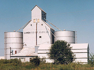
Landa is a city in Bottineau County, North Dakota, United States. The population was 41 at the 2020 census. Landa was founded in 1904.

<span class="mw-page-title-main">Lansford, North Dakota</span> City in North Dakota, United States

Lansford is a city in Bottineau County, North Dakota, United States. The population was 238 at the 2020 census. Lansford was founded in 1903.

<span class="mw-page-title-main">Maxbass, North Dakota</span> City in North Dakota, United States

Maxbass is a city in Bottineau County, North Dakota, United States. The population was 89 at the 2020 census. Maxbass was founded in 1905.

<span class="mw-page-title-main">Scranton, North Dakota</span> City in North Dakota, United States

Scranton is a small town in Bowman County, North Dakota, United States. The population was 258 at the 2020 census.

<span class="mw-page-title-main">Alice, North Dakota</span> City in North Dakota, United States

Alice is a city in Cass County, North Dakota, United States. The population was 41 at the 2020 census.

<span class="mw-page-title-main">Ayr, North Dakota</span> City in North Dakota, United States

Ayr is a city in Cass County, North Dakota, United States. The population was 11 at the 2020 census. Ayr was founded in 1883.

<span class="mw-page-title-main">North River, North Dakota</span> City in North Dakota, United States

North River is a city in Cass County, North Dakota, United States. The population was 55 at the 2020 census. North River was founded in 1973. It is a suburb/bedroom community directly adjacent to the city of Fargo.

<span class="mw-page-title-main">Wishek, North Dakota</span> City in North Dakota, United States

Wishek is a city in McIntosh County, North Dakota, United States. The population was 864 at the 2020 census.

<span class="mw-page-title-main">Hankinson, North Dakota</span> City in North Dakota, United States

Hankinson is a city in Richland County, North Dakota, United States. The population was 921 at the 2020 census. Hankinson was founded in 1886. It is part of the Wahpeton, ND–MN Micropolitan Statistical Area.

<span class="mw-page-title-main">Park River, North Dakota</span> City in North Dakota, United States

Park River is a city in Walsh County, North Dakota, United States. The population was 1,424 at the 2020 census. Park River was founded in 1884.

<span class="mw-page-title-main">Kenmare, North Dakota</span> City in North Dakota, United States

Kenmare is a city in Ward County, North Dakota, United States. The population was 961 at the 2020 census. Kenmare is part of the Minot Micropolitan Statistical Area.

<span class="mw-page-title-main">Groton, South Dakota</span> City in South Dakota, United States

Groton is a city in southeastern Brown County, South Dakota, United States. The population was 1,380 at the 2020 census.

<span class="mw-page-title-main">Whitewood, South Dakota</span> City in South Dakota, United States

Whitewood is a city in Lawrence County, South Dakota, United States. The population was 879 at the 2020 census.

<span class="mw-page-title-main">Crooks, South Dakota</span> City in South Dakota, United States

Crooks is a city in Minnehaha County, South Dakota, United States and is a suburb of Sioux Falls. The population was 1,362 at the 2020 census. Crooks was named New Hope until 1904. The town's present name honors W. A. Crooks, a local politician.

<span class="mw-page-title-main">Hartford, South Dakota</span> City in South Dakota, United States

Hartford is a suburban American city in Minnehaha County, South Dakota, a few miles northwest of Sioux Falls. Its population was 3,354 at the 2020 census.

References

  1. "ArcGIS REST Services Directory". United States Census Bureau. Retrieved September 20, 2022.
  2. 1 2 U.S. Geological Survey Geographic Names Information System: Hoople, North Dakota
  3. 1 2 3 "Explore Census Data". United States Census Bureau . Retrieved November 28, 2023.
  4. 1 2 "City and Town Population Totals: 2020-2022". United States Census Bureau. November 28, 2023. Retrieved November 28, 2023.
  5. Federal Writer's Project of the Works Progress Administration for the State of North Dakota (1977). The WPA Guide To 1930s North Dakota (2nd ed.). State Historical Society of North Dakota. p. 189. ISBN   1891419145.
  6. "US Gazetteer files 2010". United States Census Bureau. Archived from the original on January 12, 2012. Retrieved June 14, 2012.
  7. United States Census Bureau. "Census of Population and Housing" . Retrieved January 19, 2014.