Nash, North Dakota

Last updated

Nash
Nash North Dakota.jpg
Entering Nash, North Dakota from the East
USA North Dakota location map.svg
Red pog.svg
Nash
Location within the state of North Dakota
Usa edcp location map.svg
Red pog.svg
Nash
Nash (the United States)
Coordinates: 48°28′40″N97°31′28″W / 48.47778°N 97.52444°W / 48.47778; -97.52444
Country United States
State North Dakota
County Walsh
Area
[1]
  Total1.02 sq mi (2.65 km2)
  Land1.02 sq mi (2.65 km2)
  Water0.00 sq mi (0.00 km2)
Elevation
[2]
856 ft (261 m)
Population
 (2020)
  Total13
  Density12.72/sq mi (4.91/km2)
Time zone UTC-6 (Central (CST))
  Summer (DST) UTC-5 (CDT)
ZIP code
58237
Area code 701
FIPS code 38-55500
GNIS feature ID2584352 [2]

Nash is a census-designated place and unincorporated community in Walsh County, North Dakota, United States. Its population was 32 as of the 2010 census. [3] The unincorporated community is located in Farmington Township, northwest of Grafton.

Contents

Nash was designated as part of the U.S. Census Bureau's Participant Statistical Areas Program on March 31, 2010. [2] It was not counted separately during the 2000 Census, [4] but was included in the 2010 Census, [5] where a population of 32 was reported. [3]

History

Nash was founded in 1890 as a station along the Great Northern Railroad and named for the Nash brothers, pioneer settlers in the area who operated a fruit store in Grafton and started what is now the Nash Finch Company, the third-largest food wholesaler in the United States. [6] [7]

Geography

According to the United States Census Bureau, the CDP has a total area of 1.02 square miles (2.64 km2), all land. [8]

Demographics

Historical population
CensusPop.Note
2020 13
U.S. Decennial Census [9]

2010 census

As of the census [3] of 2010, there were 32 people, 12 households, and 9 families in the CDP. The population density was 31.3 inhabitants per square mile (12.1/km2). There were 13 housing units at an average density of 12.7 per square mile (4.9/km2). The racial makeup of the CDP was 93.8% White, and 6.3% from other races. Hispanic or Latino of any race were 28.1% of the population.

There were 12 households, of which 25.0% had children under the age of 18 living with them, 50.0% were married couples living together, 16.7% had a female householder with no husband present, 8.3% had a male householder with no wife present, and 25.0% were non-families. 16.7% of all households were made up of individuals, and 8.3% had someone living alone who was 65 years of age or older. The average household size was 2.67 and the average family size was 3.11.

The median age in the CDP was 37.5 years. 25.0% of residents were under the age of 18; 12.5% were between the ages of 18 and 24; 15.6% were from 25 to 44; 37.5% were from 45 to 64; and 9.4% were 65 years of age or older. The gender makeup of the CDP was 50.0% male and 50.0% female.

Related Research Articles

<span class="mw-page-title-main">Dazey, North Dakota</span> City in North Dakota, United States

Dazey is a city in Barnes County, North Dakota, United States. The population was 78 at the 2020 census. Dazey was founded in 1883 after a local farmer, Charles Dazey, donated land to start a townsite.

<span class="mw-page-title-main">Leal, North Dakota</span> City in North Dakota, United States

Leal is a city in Barnes County in the state of North Dakota. The population was 27 at the 2020 census. Leal was founded in 1892. The name comes from the Scots word for "faithful," which in the phrase laund o the leal means Heaven.

<span class="mw-page-title-main">Fort Totten, North Dakota</span> CDP in North Dakota, United States

Fort Totten is a census-designated place (CDP) in Benson County, North Dakota, United States. The population was 1,243 at the 2010 census. Fort Totten is located within the Spirit Lake Reservation and is the site of tribal headquarters. The reservation has a total population estimated at 6,000. Although not formally incorporated as a city, Fort Totten has the largest population of any community in Benson County.

<span class="mw-page-title-main">Lincoln, North Dakota</span> City in North Dakota, United States

Lincoln is a city in Burleigh County, North Dakota, United States. It is a suburb of adjacent Bismarck, and also a core city of the Bismarck-Mandan Metropolitan Statistical Area. The population was 4,257 at the 2020 census, making it the fourteenth largest city in North Dakota. Lincoln was founded in 1977.

<span class="mw-page-title-main">Erie, North Dakota</span> Census-designated place in North Dakota, United States

Erie is a census-designated place (CDP) in Cass County, North Dakota, United States. The population was 50 at the 2010 census. Established in or after 1980 by the United States Census Bureau, the CDP is named for the village of Erie, which is within its boundary. Although the rectangular boundary includes a sizeable amount of farmland, there is in fact only one residence outside the village's boundary but within that of the CDP.

<span class="mw-page-title-main">Wheatland, North Dakota</span> Census-designated place in North Dakota, United States

Wheatland is a census-designated place (CDP) in Cass County, North Dakota, United States. The population was 68 at the 2010 census.

<span class="mw-page-title-main">Kief, North Dakota</span> City in North Dakota, United States

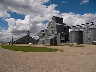
Kief is a city in McHenry County, North Dakota, United States. The population was 8 at the 2020 census. It is part of the Minot Micropolitan Statistical Area. Kief was founded in 1908.

<span class="mw-page-title-main">Mandaree, North Dakota</span> Census-designated place & Unincorporated community in North Dakota, United States

Mandaree is a census-designated place (CDP) in McKenzie County, North Dakota, United States. The population was 596 at the 2010 census.

<span class="mw-page-title-main">Cannon Ball, North Dakota</span> CDP in Standing Rock Indian Reservation, United States

Cannon Ball is a census-designated place (CDP) on the Standing Rock Indian Reservation and in Sioux County, North Dakota, United States. It is located in the northeastern part of Sioux County, having developed at the confluence of the Cannonball River and Lake Oahe of the Missouri River. The population was 875 at the 2010 census.

<span class="mw-page-title-main">Buxton, North Dakota</span> City in North Dakota, United States

Buxton is a city in Traill County, North Dakota, United States. The population was 348 at the 2020 census. Buxton was founded in 1880. Today, it has become a bedroom community for the nearby Greater Grand Forks metropolitan area.

<span class="mw-page-title-main">Grafton, North Dakota</span> City in North Dakota, United States

Grafton is a city in the State of North Dakota and is the county seat of Walsh County. As of the 2020 Census, the city of Grafton had a population of 4,170, making it the fifteenth largest city in North Dakota. Grafton was founded in 1881.

<span class="mw-page-title-main">Fort Thompson, South Dakota</span> CDP in South Dakota, United States

Fort Thompson is a census-designated place (CDP) in Buffalo County, South Dakota, United States. The population was 1,282 at the 2010 census, making it the largest settlement on the Crow Creek Reservation.

<span class="mw-page-title-main">North Eagle Butte, South Dakota</span> Census-designated place in South Dakota, United States

North Eagle Butte is a census-designated place (CDP) in Dewey County, South Dakota, United States, along the 45th parallel. The population was 1,879 at the 2020 census.

<span class="mw-page-title-main">North Spearfish, South Dakota</span> Census-designated place in South Dakota, United States

North Spearfish is a census-designated place (CDP) in Lawrence County, South Dakota, United States. The population was 2,366 at the 2020 census.

<span class="mw-page-title-main">Ashland Heights, South Dakota</span> CDP in South Dakota, United States

Ashland Heights is a census-designated place (CDP) and unincorporated community in Pennington County, South Dakota, United States. The population was 678 at the 2020 census.

<span class="mw-page-title-main">Oglala, South Dakota</span> CDP in South Dakota, United States

Oglala is a census-designated place (CDP) in West Oglala Lakota Unorganized Territory equivalent, Oglala Lakota County, South Dakota, United States. The population was 1,282 at the 2020 census. Its location is in the northwest of the Pine Ridge Indian Reservation.

<span class="mw-page-title-main">Selz, North Dakota</span> Census-designated place & Unincorporated community in North Dakota, United States

Selz is a census-designated place and unincorporated community in Pierce County, North Dakota, United States. Its population was 40 as of the 2020 census.

<span class="mw-page-title-main">Orrin, North Dakota</span> Census-designated place & Unincorporated community in North Dakota, United States

Orrin is a census-designated place and unincorporated community in Pierce County, North Dakota, United States. Its population was 22 as of the 2010 census.

<span class="mw-page-title-main">Auburn, North Dakota</span> Census-designated place & unincorporated community in North Dakota, United States

Auburn is a census-designated place and unincorporated community in Walsh County, North Dakota, United States. Its population was 48 as of the 2010 census.

<span class="mw-page-title-main">Heimdal, North Dakota</span> Census-designated place & Unincorporated community in North Dakota, United States

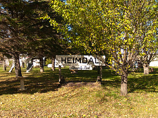
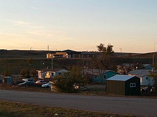
Heimdal is a census-designated place and unincorporated community in Wells County, North Dakota, United States. Its population was 16 as of the 2020 census.

References

  1. "ArcGIS REST Services Directory". United States Census Bureau. Retrieved September 20, 2022.
  2. 1 2 3 U.S. Geological Survey Geographic Names Information System: Nash, North Dakota
  3. 1 2 3 "2010 Census Redistricting Data (Public Law 94-171) Summary File". American FactFinder. United States Census Bureau . Retrieved May 2, 2011.[ dead link ]
  4. U.S. Census Bureau (2003). "Population and Housing Unit Counts, North Dakota" (PDF). 2000 Census of Population and Housing. Government Printing Office . Retrieved July 20, 2008.
  5. U.S. Census Bureau (February 13, 2008). "Census Designated Place (CDP) Program for the 2010 Census—Final Criteria" (PDF). Federal Register . Archived from the original (PDF) on October 18, 2010. Retrieved July 13, 2010.
  6. Wick, Douglas A. (1988). North Dakota Place Names. Bismarck, North Dakota: Hedemarken Collectibles. p. 135. ISBN   0-9620968-0-6. OCLC   191277027. Archived from the original on March 23, 2012. Retrieved May 3, 2011.
  7. Williams, Mary Ann (Barnes) (1966). Origins of North Dakota Place Names. Bismarck, North Dakota: Bismarck Tribune, 1966. p. 328. OCLC   431626.
  8. "US Gazetteer files: 2010, 2000, and 1990". United States Census Bureau. February 12, 2011. Retrieved April 23, 2011.
  9. "Census of Population and Housing". Census.gov. Retrieved June 4, 2016.