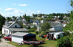
Hornepayne

Last updated

Hornepayne
Township of Hornepayne
Hornepayne ON 2.JPG
Logo of the township of Hornepayne.png
Canada Ontario location map 2.svg
Red pog.svg
Hornepayne
Coordinates: 49°13′N84°47′W / 49.217°N 84.783°W / 49.217; -84.783
CountryCanada
Province Ontario
District Algoma
Established1915
Incorporated1927
Government
  TypeTownship
  MayorCheryl T. Fort
  Federal riding Algoma—Manitoulin—Kapuskasing
  Prov. riding Algoma—Manitoulin
Area
[1]
  Land203.04 km2 (78.39 sq mi)
Elevation
[2]
332 m (1,089 ft)
Population
 (2021) [1]
  Total968
  Density4.8/km2 (12/sq mi)
Time zone UTC-5 (EST)
  Summer (DST) UTC-4 (EDT)
Postal Code
P0M
Area code 807
Highways Ontario Highway 631.svg  Highway 631
Website www.townshipofhornepayne.ca OOjs UI icon edit-ltr-progressive.svg

Hornepayne is a township of 980 people (Canada 2016 Census) in the Algoma District of Ontario, Canada. The town was established in 1915 as Fitzback when the Canadian Northern Railway's transcontinental line was built through the area. It was renamed Hornepayne in 1920 after British financier Robert Horne-Payne. [3] [4] The municipality was originally named Wicksteed Township after the geographic township in which it is located. It was renamed Hornepayne, after its primary community, in 1986.

Contents

History

Two Cree women with snowshoes photographed at the Morrison (later Shekak) River settlement in 1928. Cree women at Morrison River near Hornepayne.jpg
Two Cree women with snowshoes photographed at the Morrison (later Shekak) River settlement in 1928.

First Nations people have lived in the area for centuries, as indicated by archaeological evidence such as potsherd fragments. [5] These are concentrated in the areas around Lake Nagagamisis, which is 30 kilometres (19 mi) to the north of Hornepayne, as well as the Shekak River to the west, rather than near Hornepayne itself, which before the arrival of the railway was largely remote and uninhabited. [4] :87 In the 19th century, they became involved in the fur trade and the mercantile activities of the Hudson's Bay Company. [5] By the early 1900s, they consisted of three Cree families living at Lake Nagagamisis, along with a number of Ojibwe who were possibly originally from Heron Bay. [4] :87 With the opening of the railway, they abandoned their existing trading post on Lake Nagagamisis in 1926 for a new settlement on Shekak Lake, which was closer to the rail line. [4] :87 By the 1940s, many of them had moved to Hornepayne to work in the railway and timber industries based in the town. [5] A number of their descendants are members of the Hornepayne First Nation, a member organization of the Nishnawbe Aski Nation.

Hornepayne differs from a number of older Northern Ontario settlements due to its distance from major waterways, making it relatively inaccessible before the advent of rail transportation in the north. [4] :87 The townsite was originally surveyed in 1877, when possible routes for the Canadian Pacific Railway transcontinental mainline were being explored. [4] :87 Instead of Canadian Pacific, however, Hornepayne would become associated with the Canadian Northern Railway (CNoR), one of several railways which were later amalgamated into the Canadian National Railways (CN) system during the 20th century. The Canadian Northern built its line through the area in 1915 and established a divisional point on the line called Fitzback. In 1919, the Canadian Northern was amalgamated into the Canadian National system. A year later, in 1920, the point was renamed Hornepayne, after the railway financier Robert Montgomery Horne-Payne. [4] :87

In the steam era, the railway system was labour-intensive and required many workers for maintenance of way, crew changes, and to resupply trains with coal and water at fixed intervals. This circumstance fostered the growth of "railway towns", as railway workers began to create permanent settlements to live in with their families. Sections of track were broken up into subdivisions, which were approximately 200 kilometres (120 mi) long and were separated by divisional points. Divisional points acted as a sort of local "headquarters" for the railways, and were very important for their operations. Additionally, most steam trains needed to be resupplied with coal at least once and water at least three times when passing through each subdivision, requiring railways to maintain even more permanent or semi-permanent settlements to support these operations. Hornepayne, as a divisional point, sat at the joining place between the CN Oba Subdivision (east to Foleyet) and the CN Caramat Subdivision (west to Nakina). [4] :78

Hornepayne initially had few permanent structures aside from the railway station, but was inhabited mostly by railway workers, who were young and well-paid for the era. A one-room schoolhouse was constructed in 1921 at the corner of First and Front streets, partially replacing the railway coach which was previously used as a school, though senior students were shifted to the old railway station. A new railway station, which was demolished in 2020, was also constructed in 1921. The situation was resolved when town ratepayers authorized $30,000 be spent on the construction of a new four-room school in the winter of 1923. [4] :88

Throughout the 1920s, Hornepayne grew, and soon was home to several grocery and general stores, as well as a butcher shop, a dress shop, a pharmacy, a Hudson's Bay Company store, two barbershops, a town hall, two restaurants, a bowling alley, two pool halls, and two hotels, one of which was owned by CN and one of which was independent. [4] :88 The town lacked in fresh fruit and vegetables early on, which were imported by rail from Port Arthur. Later, two farms, one of which was a dairy farm, were established in the area to feed the town. By the 1930s, one farm had around four hundred chickens. [4] :89 Due to its remote location, household electricity was slow to arrive in Hornepayne. Diesel-generated power was available from CN for most of the town starting in the 1930s, but the town would only be connected with the Ontario electrical grid in 1962. [4] :89

Highway 631 as seen in 2009. Hwy 631 ON 2.JPG
Highway 631 as seen in 2009.

The town was incorporated in 1927–28 by local petition, and was poised to become a regional centre. A series of devastating fires in 1929–31, however, destroyed many of the town's commercial buildings, as well as the CNR shops. Rail traffic slowed during the Great Depression, and the town struggled, with some residents finding employment on highway construction under government public works funding. [4] :90 This difficult and slow work culminated in the opening of the northern section of Highway 631 in 1959, linking Hornepayne with Highway 11. In 1973, the highway was extended to the south to connect to Highway 17 at White River. [4] :91

The Hallmark Centre was a mixed-use development in the town, which opened in 1982 and closed in 2011. Hornepayne ON.jpg
The Hallmark Centre was a mixed-use development in the town, which opened in 1982 and closed in 2011.

In the 1970s and 1980s, Hornepayne underwent a considerable redevelopment push, spurring the southern highway extension, the opening of the Hornepayne Municipal Airport, and the creation of the mixed use Hallmark Centre "mall", merging together a number of commercial, recreational, and institutional aspects of the town. At various times, it included residences for CN temporary workers (an evolution of the CN bunkhouses which were demolished in the 1950s), a post office, the local high school, a hotel, a library, a swimming pool, a gym, apartments, and a Hudson's Bay Company Northern Store department store. Many existing businesses relocated to the complex, though some remained at their old locations. [4] :92 Over the years, the complex became less and less commercially viable, and closed entirely in 2011.

Geography

Geology

Hornepayne is situated in the Horseshoe of Rock, which forms the Pre-Cambrian area, which surrounds Hudson Bay. It is the oldest rock in the world, containing the famous Keewatin Greenstone. Massive Granite intrusions, of which Tank Hill to is a good example, is the predominant rock in the area.

Greenstone can be found six miles north along highway 631 and in numerous bands along Government Lake Road. Volcanoes were numerous, and specimens of their eruptions in the soil can be found today. The Pre-Cambrian was covered by at least three Ice Ages which, with glaciers miles high, bulldozed the mountains away just as a bulldozer today would level a small hill. The rock and earth were moved as far south as Wisconsin.

Evidence of glacial scratches can be found on Tank Hill. The sand hills near Cedar Point are eskers left by the Glaciers. Boulders, small rocks, and clay, are scattered throughout the area, part of the glacial wash. A typical volcanic core is to be found about five miles north. The highway runs through it. Samples of volcanics, such as garnets, serpentine, and rhyolite, can be found. Most of the Pre-Cambrian is covered by a thin layer of organic soil and clay. Hornepayne is approximately eight miles north of the height of land. Drainage is poor in the area, which has many muskeg swamps.[ citation needed ]

Climate

Hornepayne experiences a unique subarctic microclimate (Dfc) due to its elevation of 336 meters (1,101 feet) and location in Northern Ontario. Winters are long, snowy, and very cold for Ontario. Summers are generally warm with cool nights. Winter usually begins around Halloween, lasting through March and into April, though wintry days can sometimes be experienced even later in the season. Snowfall is abundant, starting to fall usually sometime in October and keeps falling into April, with snowfalls in May not uncommon. Hornepayne is one of the driest communities in Ontario, receiving only 656.4 mm (25.84 inches) of precipitation falling on only 105.5 days. [6]

Climate data for Hornepayne, Ontario (1971–2000)
MonthJanFebMarAprMayJunJulAugSepOctNovDecYear
Record high °C (°F)6.7
(44.1)
12.8
(55.0)
18.9
(66.0)
28.9
(84.0)
33.0
(91.4)
37.2
(99.0)
37.2
(99.0)
34.4
(93.9)
31.7
(89.1)
31.7
(89.1)
18.0
(64.4)
12.5
(54.5)
37.2
(99.0)
Mean daily maximum °C (°F)−13.1
(8.4)
−9.2
(15.4)
−2.6
(27.3)
6.9
(44.4)
16.4
(61.5)
21.0
(69.8)
24.1
(75.4)
22.0
(71.6)
15.3
(59.5)
8.6
(47.5)
0.5
(32.9)
−8.8
(16.2)
6.8
(44.2)
Daily mean °C (°F)−19.7
(−3.5)
−16
(3)
−9.2
(15.4)
0.4
(32.7)
8.9
(48.0)
13.4
(56.1)
16.4
(61.5)
14.2
(57.6)
8.8
(47.8)
3.5
(38.3)
−3.8
(25.2)
−14.5
(5.9)
0.2
(32.4)
Mean daily minimum °C (°F)−26.1
(−15.0)
−22.7
(−8.9)
−15.7
(3.7)
−6.1
(21.0)
1.5
(34.7)
5.7
(42.3)
8.6
(47.5)
8.5
(47.3)
2.2
(36.0)
−1.6
(29.1)
−8.1
(17.4)
−20.3
(−4.5)
−6.3
(20.7)
Record low °C (°F)−49.4
(−56.9)
−52.2
(−62.0)
−43.9
(−47.0)
−37.2
(−35.0)
−15
(5)
−12.2
(10.0)
−9.4
(15.1)
−7.2
(19.0)
−12.2
(10.0)
−27.2
(−17.0)
−40
(−40)
−52.2
(−62.0)
−52.2
(−62.0)
Average precipitation mm (inches)53.4
(2.10)
38.5
(1.52)
38.9
(1.53)
28.7
(1.13)
51.4
(2.02)
81.5
(3.21)
65.4
(2.57)
67.2
(2.65)
70.3
(2.77)
60.8
(2.39)
49.3
(1.94)
51.0
(2.01)
656.4
(25.84)
Average rainfall mm (inches)0.1
(0.00)
1.6
(0.06)
3.9
(0.15)
11.1
(0.44)
45.3
(1.78)
81.5
(3.21)
65.4
(2.57)
67.2
(2.65)
69.4
(2.73)
48.9
(1.93)
15.1
(0.59)
0.9
(0.04)
410.5
(16.16)
Average snowfall cm (inches)53.3
(21.0)
36.9
(14.5)
35.0
(13.8)
17.6
(6.9)
6.1
(2.4)
0.0
(0.0)
0.0
(0.0)
0.0
(0.0)
0.9
(0.4)
12.6
(5.0)
34.3
(13.5)
50.1
(19.7)
246.7
(97.1)
Average precipitation days (≥ 0.2 mm)8.66.87.35.97.39.28.69.412.910.99.29.4105.5
Average rainy days (≥ 0.2 mm)0.120.381.12.86.59.28.69.412.88.62.60.4162.5
Average snowy days (≥ 0.2 cm)8.56.76.43.61.00.00.00.00.222.97.19.345.7
Source: Environment Canada [7]

Demographics

In the 2021 Census of Population conducted by Statistics Canada, Hornepayne had a population of 968 living in 439 of its 515 total private dwellings, a change of -1.2% from its 2016 population of 980. With a land area of 203.04 km2 (78.39 sq mi), it had a population density of 4.8/km2 (12.3/sq mi) in 2021. [1]

Canada census – Hornepayne community profile
2021 2016 2011
Population968 (-1.2% from 2016)980 (-6.7% from 2011)1,050 (-13.2% from 2006)
Land area203.04 km2 (78.39 sq mi)204.07 km2 (78.79 sq mi)204.52 km2 (78.97 sq mi)
Population density4.8/km2 (12/sq mi)4.8/km2 (12/sq mi)5.1/km2 (13/sq mi)
Median age41.2 (M: 40.8, F: 42.0)42.9 (M: 43.1, F: 42.4)41.2 (M: 41.0, F: 41.5)
Private dwellings515 (total)  439 (occupied)514 (total) 518 (total) 
Median household income$102,000$99,584
References: 2021 [8] 2016 [9] 2011 [10] earlier [11] [12]
Historical census populations – Hornepayne
YearPop.±%
1921 384    
1931 790+105.7%
1941 910+15.2%
1951 1,282+40.9%
1956 1,659+29.4%
1961 1,727+4.1%
YearPop.±%
1966 1,790+3.6%
1971 1,825+2.0%
1976 1,719−5.8%
1981 1,850+7.6%
1986 1,843−0.4%
1991 1,610−12.6%
YearPop.±%
1996 1,480−8.1%
2001 1,362−8.0%
2006 1,209−11.2%
2011 1,050−13.2%
2016 980−6.7%
2021 968−1.2%
Population counts are not adjusted for boundary changes.
Source: Statistics Canada [1] [13] [14]

Mother tongue (2021): [1]

Economy

Hornepayne serves as a railway divisional point on the main Canadian National Railway line. The forestry industry (by way of Haavaldsrud's Timber Company [15] ) is the major employer to the local economy. Hunting- and fishing-related tourism in the area (particularly just north of the town in nearby Nagagami Lake Provincial Park) is served by several small companies. [16] [17] [18]

The township of Hornepayne has been the proposed site of a low level nuclear waste storage facility for some time. The town's community liaison group chose to withdraw from this development in the early 1990s, [19] but as of May 2010 the township is still being considered for nuclear waste management/storage. [20]

Transportation

Highway 631 runs through Hornepayne and connects it to Highway 11 in the north and Highway 17 at White River in the south, both of which are part of the Trans-Canada Highway system.

Hornepayne is served by the Canadian , Canada's transcontinental passenger rail service, which is operated by Via Rail and stops at Hornepayne station. The rail line through the town is part of the Canadian National Railway and was originally constructed by the Canadian Northern Railway in 1915. [4] :87 Hornepayne, a divisional point on the railway, marks the point that two rail subdivisions join with each other: the CN Caramat Subdivision to the west (ending at Nakina) and the CN Ruel Subdivision. [4] :78

The town is also home to the Hornepayne Municipal Airport.

The CN rail yard; the old station in the background had been abandoned and was demolished in 2020. Hornepayne ON 3.JPG
The CN rail yard; the old station in the background had been abandoned and was demolished in 2020.
Passengers milling around the train at the station stop in Hornepayne. VIA - The Canadian - End Car.jpg
Passengers milling around the train at the station stop in Hornepayne.

See also

Related Research Articles

<span class="mw-page-title-main">Kawartha Lakes</span> City in Ontario, Canada

The City of Kawartha Lakes is a unitary municipality in Central Ontario, Canada. It is a municipality legally structured as a single-tier city; however, Kawartha Lakes is the size of a typical Ontario county and is mostly rural. It is the second largest single-tier municipality in Ontario by land area.

<span class="mw-page-title-main">Cochrane, Ontario</span> Town in Ontario, Canada

Cochrane is a town in northeastern Ontario, Canada. It is located east of Kapuskasing, northeast of Timmins, south of Moosonee, and north of Iroquois Falls. It is about a one-hour drive from Timmins, the major city of the region. It is the seat of Cochrane District. The town's population is made up of about half anglophone and half francophone residents.

<span class="mw-page-title-main">Sables-Spanish Rivers</span> Township in Ontario, Canada

Sables-Spanish Rivers is a township in Ontario, Canada, on the north shore of Georgian Bay. It is located in the Sudbury District, approximately 70 kilometres (43 mi) west of Sudbury.

<span class="mw-page-title-main">Greenstone, Ontario</span> Municipality in Ontario, Canada

Greenstone is an amalgamated town in the Canadian province of Ontario with a population of 4,636 according to the 2016 Canadian census. It stretches along Highway 11 from Lake Nipigon to Longlac and covers 2,767.19 km2 (1,068.42 sq mi).

<span class="mw-page-title-main">Ramara</span> Township in Ontario, Canada

Ramara is a lower-tier township municipality in Simcoe County, Ontario, Canada.

<span class="mw-page-title-main">Oro-Medonte</span> Township in Simcoe County, Ontario, Canada

Oro-Medonte is a township in south-central Ontario, Canada, on the northwestern shores of Lake Simcoe in Simcoe County.

<span class="mw-page-title-main">West Nipissing</span> Municipality in Ontario, Canada

West Nipissing is a municipality in Northeastern Ontario, Canada, on Lake Nipissing in the Nipissing District. It was formed on January 1, 1999, with the amalgamation of seventeen and a half former towns, villages, townships and unorganized communities.

<span class="mw-page-title-main">Markstay-Warren</span> Municipality in Ontario, Canada

Markstay-Warren is a town in the Canadian province of Ontario, located in the Sudbury District. Highway 17, from the city limits of Greater Sudbury to the Sudbury District's border with Nipissing District, lies entirely within Markstay-Warren. The town had a population of 2,656 in the Canada 2016 Census.

<span class="mw-page-title-main">Nipigon</span> Township in Ontario, Canada

Nipigon is a township in Thunder Bay District, Northwestern Ontario, Canada, located along the west side of the Nipigon River and south of the small Helen Lake running between Lake Nipigon and Lake Superior. Lake Nipigon is located approximately 25 kilometres (16 mi) north of Nipigon. Located at latitude 49.0125° N, Nipigon is the northernmost community on the Great Lakes.

<span class="mw-page-title-main">Bonfield, Ontario</span> Township in Ontario, Canada

Bonfield is a township in northeastern Ontario, Canada, on the Mattawa River in Nipissing District.

<span class="mw-page-title-main">East Ferris</span> Township in Ontario, Canada

East Ferris is a township in northeastern Ontario, Canada located between Trout Lake and Lake Nosbonsing in the District of Nipissing. West Ferris has long been annexed into the city of North Bay.

<span class="mw-page-title-main">Highlands East, Ontario</span> Township Municipality in Ontario, Canada

Highlands East is a township municipality located in Haliburton County, Ontario, Canada.

<span class="mw-page-title-main">Foleyet</span> Place in Ontario, Canada

Foleyet is an unincorporated community in the Unorganized North Part of Sudbury District in Northeastern Ontario, Canada, midway between Chapleau and Timmins on Highway 101. The town was created during the construction of the Canadian Northern Railway (CNR) through the area in the early years of the 20th century.

<span class="mw-page-title-main">Englehart</span> Town in Ontario, Canada

Englehart is a town in the Canadian province of Ontario, located on the Blanche River in the Timiskaming District.

<span class="mw-page-title-main">Moonbeam, Ontario</span> Township in Ontario, Canada

Moonbeam is a township in Ontario, Canada, located in the Cochrane District. It is located between the communities of Fauquier and Kitigan along Ontario Highway 11, south of René Brunelle Provincial Park. It is known for its roadside flying saucer, which is also featured prominently in promotional material. The town is most famously referenced in the song "Fly" by the Canadian rock band The Tragically Hip, on their 2006 album World Container.

<span class="mw-page-title-main">Hastings Highlands</span> Municipality in Ontario, Canada

Hastings Highlands is a township in the Canadian province of Ontario.

<span class="mw-page-title-main">The Blue Mountains, Ontario</span> Town in Ontario, Canada

The Blue Mountains is a town in Grey County, southwestern Ontario, Canada, located where the Beaver River flows into Nottawasaga Bay. It is named for the Blue Mountain, and hence the economy of the town is centred on tourism, particularly on the Blue Mountain ski resort and the private Georgian Peaks, Osler, Craigleith and Alpine Ski Clubs.

<span class="mw-page-title-main">South Algonquin</span> Township municipality in Ontario, Canada

South Algonquin is a township municipality in Nipissing District, Ontario, Canada. Located south of Algonquin Provincial Park, it is the sole populated portion of the district that lies south of the traditional dividing line between Northern Ontario and Southern Ontario and is closer connected to Renfrew County as opposed to the core portions of Nipissing District.

<span class="mw-page-title-main">North Algona Wilberforce</span> Township municipality in Ontario, Canada

North Algona Wilberforce is a township municipality in Renfrew County, Ontario, Canada. It has a population of 2,873. The township was formed in 1999 when the North Algona and Wilberforce townships were amalgamated.

<span class="mw-page-title-main">Wollaston, Ontario</span> Township in Ontario, Canada

Wollaston is an incorporated township in Hastings County, Ontario, Canada. The township had a population of 670 in the Canada 2016 Census.

References

  1. 1 2 3 4 5 "Hornepayne (Code 3557096) Census Profile". 2021 census . Government of Canada - Statistics Canada . Retrieved 2024-03-11.
  2. White, James (1915). Altitudes in the Dominion of Canada (2nd ed.). Ottawa: Commission of Conservation. p. 240.
  3. Roy, Patricia. "Robert Montgomery Horne-Payne". The Canadian Encyclopedia. Retrieved 3 October 2016.
  4. 1 2 3 4 5 6 7 8 9 10 11 12 13 14 15 16 17 Douglas, Dan (1995). Northern Algoma: A People's History. Toronto: Dundurn Press. ISBN   1-55002-235-0.
  5. 1 2 3 "History". Hornepayne First Nation . Retrieved 26 December 2020.
  6. "Hornepayne, Ontario, Canada Weather Forecast and Conditions - The Weather Channel | Weather.com". The Weather Channel. Retrieved 2020-04-03.
  7. "Hornepayne, Ontario". Canadian Climate Normals 1971–2000. Environment Canada. 31 October 2011. Retrieved 24 April 2015.
  8. "2021 Community Profiles". 2021 Canadian Census . Statistics Canada. February 4, 2022. Retrieved 2023-10-19.
  9. "2016 Community Profiles". 2016 Canadian Census . Statistics Canada. August 12, 2021. Retrieved 2017-04-13.
  10. "2011 Community Profiles". 2011 Canadian Census . Statistics Canada. March 21, 2019. Retrieved 2012-02-16.
  11. "2006 Community Profiles". 2006 Canadian Census . Statistics Canada. August 20, 2019.
  12. "2001 Community Profiles". 2001 Canadian Census . Statistics Canada. July 18, 2021.
  13. 1996, 2001, 2006, 2011 census
  14. "Hornepayne census profile". 2016 Census of Population . Statistics Canada. Retrieved 2018-04-13.
  15. "Olav Haavaldsrud Timber Co. LTD". Archived from the original on 2012-04-25. Retrieved 2011-11-16.
  16. "Hornepayne, Northern Ontario Tourist Outfitters, Canada". Archived from the original on 2011-05-20. Retrieved 2011-09-21.
  17. "Home". pronorthoutfitters.com.
  18. "Johnstons Fly in Fishing Outpost Camps - Hornepayne, Ontario". Archived from the original on 2012-04-25. Retrieved 2011-11-16.
  19. http://deepblue.lib.umich.edu/bitstream/2027.42/73397/1/j.1754-7121.1994.tb00885.x.pdf [ bare URL PDF ]
  20. "Reports | NWMO" (PDF).