Prince, Ontario

Last updated

Prince
Township of Prince
Gros Cap ON.JPG
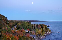
The end of Highway 550 in Gros Cap.
Canada Ontario location map 2.svg
Red pog.svg
Prince
Coordinates: 46°32′N84°30′W / 46.533°N 84.500°W / 46.533; -84.500
Country Canada
Province Ontario
District Algoma
Government
  TypeTownship
  ReeveEnzo Palumbo
   MP Terry Sheehan
   MPP Mike Mantha
Area
[1]
  Land85.30 km2 (32.93 sq mi)
Population
 (2016) [1]
  Total1,010
  Density11.8/km2 (31/sq mi)
Time zone UTC-5 (EST)
  Summer (DST) UTC-4 (EDT)
Postal code span
P6A
Area code(s) 705, 249
Website www.twp.prince.on.ca

Prince is a township in the Canadian province of Ontario, located within the Algoma District northwest of Sault Ste. Marie. Although the township is not part of the city of Sault Ste. Marie, some municipal services are contracted to the city.

Contents

The only named community within the township is Gros Cap. Most mail and telephone service in the township is part of Sault Ste. Marie's sortation area and telephone exchange.

Naturally spring fed, Princ e Lake is a long-standing settlement for permanent residents and vacationers. In 2007, Tom Connelly was elected Mayor of the Lake and his son Kyle Connelly has served as the deputy, both by unanimous decision.

One of the largest wind farms in Canada, the Prince Township Wind Farm, is centred in Prince Township. It provides enough electricity to serve 20,000 homes. The project is run by Brascan Power Wind.

The township was named after John Prince, the first judge in the Algoma District.

Demographics

In the 2021 Census of Population conducted by Statistics Canada, Prince had a population of 975 living in 394 of its 462 total private dwellings, a change of -3.5% from its 2016 population of 1,010. With a land area of 84.98 km2 (32.81 sq mi), it had a population density of 11.5/km2 (29.7/sq mi) in 2021. [2]

Canada census – Prince community profile
2021 2016 2011
Population975 (-3.5% from 2016)1,010 (-2.0% from 2011)1,031 (6.2% from 2006)
Land area84.98 km2 (32.81 sq mi)85.30 km2 (32.93 sq mi)85.31 km2 (32.94 sq mi)
Population density11.5/km2 (30/sq mi)11.8/km2 (31/sq mi)12.1/km2 (31/sq mi)
Median age51.2 (M: 50.8, F: 51.2)48.1 (M: 48.6, F: 47.6)
Private dwellings395 (total) 459 (total) 466 (total) 
Median household income
References: 2021 [3] 2016 [4] 2011 [5] earlier [6] [7]

Population trend: [8]

Canadian Shield outcropping in Prince Township Canadian Shield outcrop near Gros-Cap.jpg
Canadian Shield outcropping in Prince Township

See also

Related Research Articles

<span class="mw-page-title-main">Algoma District</span> District in Ontario, Canada

Algoma District is a district and census division in Northeastern Ontario in the Canadian province of Ontario.

<span class="mw-page-title-main">Wawa, Ontario</span> Municipality in Ontario, Canada

Wawa is a township in the Canadian province of Ontario in the Algoma District. Formerly known as the Township of Michipicoten, named after a nearby river of that name, the township was officially renamed in 2007 for its largest and best-known community of Wawa, located on the western shores of Wawa Lake.

<span class="mw-page-title-main">Algoma—Manitoulin—Kapuskasing</span> Federal electoral district in Ontario, Canada

Algoma—Manitoulin—Kapuskasing is a federal electoral district in Ontario, Canada, that has been represented in the House of Commons of Canada since 2004. The area was represented by the riding of Algoma from 1867 to 1904 and from 1968 to 1996 and then by Algoma—Manitoulin from 1996 to 2004.

<span class="mw-page-title-main">Hearst, Ontario</span> Town in Ontario, Canada

Hearst is a town in the district of Cochrane, Ontario, Canada. It is located on the Mattawishkwia River in Northern Ontario, approximately 92 kilometres (57 mi) west of Kapuskasing, approximately 520 kilometres (320 mi) east of Thunder Bay along Highway 11. At Hearst, Highway 583 extends northward to Lac-Sainte-Thérèse and southward to Jogues, Coppell and Mead. Just over 96% of the town's residents speak French as their mother language, the highest proportion in Ontario.

<span class="mw-page-title-main">Marathon, Ontario</span> Town in Ontario, Canada

Marathon is a town in the Canadian province of Ontario, located in Thunder Bay District, on the north shore of Lake Superior north of Pukaskwa National Park.

<span class="mw-page-title-main">Sault Ste. Marie (federal electoral district)</span> Federal electoral district in Ontario, Canada

Sault Ste. Marie is a federal electoral district in Ontario, Canada, that has been represented in the House of Commons of Canada since 1968.

<span class="mw-page-title-main">Nipigon</span> Township in Ontario, Canada

Nipigon is a township in Thunder Bay District, Northwestern Ontario, Canada, located along the west side of the Nipigon River and south of the small Lake Helen running between Lake Nipigon and Lake Superior. Lake Nipigon is located approximately 25 kilometres (16 mi) north of Nipigon. Located at latitude 49.0125° N, Nipigon is the northernmost community on the Great Lakes.

<span class="mw-page-title-main">Unorganized North Algoma District</span> Unorganized area in Ontario, Canada

Unorganized North Algoma District is an unorganized area in northeastern Ontario, Canada, comprising all areas in Algoma District, north of the Sault Ste. Marie to Elliot Lake corridor, which are not part of an incorporated municipality or a First Nation. It covers 44,077.03 km2 (17,018.24 sq mi) of land, and had a population of 6050 in 2021. Many of these communities were/are stations on the Algoma Central Railway or were logging/mining towns.

<span class="mw-page-title-main">South Stormont</span> Township in Ontario, Canada

South Stormont is a township in eastern Ontario, Canada, in the United Counties of Stormont, Dundas and Glengarry. It is located 53 kilometres (33 mi) southeast of Ottawa. South Stormont borders on, but does not include, the city of Cornwall.

<span class="mw-page-title-main">Hilton Beach</span> Village in Ontario, Canada

Hilton Beach is a village located in Algoma District, Ontario, Canada. It is located on the northeastern shore of St. Joseph Island in the North Channel of Lake Huron, approximately 60 kilometres from Sault Ste. Marie. The village had a population of 175 and a land area of 2.62 km² per the Canada 2016 Census.

<span class="mw-page-title-main">Thessalon</span> Town in Ontario, Canada

Thessalon is a town in the Canadian province of Ontario, located at the junction of Highway 17 and Highway 129 on the north shore of Lake Huron. It is surrounded by, but not part of, the municipality of Huron Shores, and is part of Algoma District. The main industries are timber and tourism. The town is a popular retirement community. It is the administrative headquarters of the Thessalon First Nation.

<span class="mw-page-title-main">Manitouwadge</span> Township in Ontario, Canada

Manitouwadge is a township in the Canadian province of Ontario. It is located in the Thunder Bay District, at the north end of Highway 614, 331 kilometres (206 mi) east of Thunder Bay and 378 kilometres (235 mi) north-west of Sault Ste. Marie.

<span class="mw-page-title-main">Sault Ste. Marie (provincial electoral district)</span> Provincial electoral district in Ontario, Canada

Sault Ste. Marie is a provincial electoral district in the Legislative Assembly of Ontario, representing the City of Sault Ste. Marie.

<span class="mw-page-title-main">Johnson, Ontario</span> Township in Ontario, Canada

Johnson is a township in the Canadian province of Ontario, located within the Algoma District. The township had a population of 751 in the Canada 2016 Census, up from 750 in the 2011 census.

<span class="mw-page-title-main">Baldwin, Ontario</span> Township in Ontario, Canada

Baldwin is a township in the Canadian province of Ontario. Located in Sudbury District north of Espanola, the township's two main communities and population centres are McKerrow and Lorne.

<span class="mw-page-title-main">Cockburn Island (Ontario)</span> Township municipality in Ontario, Canada

Cockburn Island is an island and township municipality in the Canadian province of Ontario, located in the Manitoulin District. It is separated from the westernmost point of Manitoulin Island by the Mississagi Strait, and from Michigan's Drummond Island by the False Detour Channel. The island is incorporated as and coterminous with the municipal Township of Cockburn Island.

<span class="mw-page-title-main">Spanish, Ontario</span> Town in Ontario, Canada

Spanish is a town in the Canadian province of Ontario, located on Trans-Canada Highway 17 in the Algoma District near the border of the Sudbury District. Formerly known as the Township of Shedden, the municipality adopted its current status and name in 2004, taking the name of its largest community.

<span class="mw-page-title-main">Plummer Additional</span> Township in Ontario, Canada

Plummer Additional is a township and single tier municipality located in Algoma District in Northeastern Ontario, Canada. The township had a population of 660 in the Canada 2016 Census.

<span class="mw-page-title-main">Tarbutt</span> Township in Ontario, Canada

Tarbutt is a township in the Canadian province of Ontario, located within the Algoma District. The township is about 40 kilometres (25 mi) east of Sault Ste. Marie.

<span class="mw-page-title-main">Sault Ste. Marie, Ontario</span> City in Ontario, Canada

Sault Ste. Marie is a city in Ontario, Canada. The third-largest city in Northern Ontario after Sudbury and Thunder Bay, it is located on the St. Mary's River on the Canada–US border. To the southwest, across the river, is the United States and the Michigan city of the same name. The two cities are joined by the Sault Ste. Marie International Bridge, which connects Interstate 75 on the Michigan side and Huron Street on the Ontario side. Shipping traffic in the Great Lakes system bypasses the Saint Mary's Rapids via the American Soo Locks, the world's busiest canal in terms of tonnage that passes through it, while smaller recreational and tour boats use the Canadian Sault Ste. Marie Canal.

References

  1. 1 2 "Prince census profile". 2016 Census of Population . Statistics Canada. 8 February 2017. Retrieved 2019-06-04.
  2. "Population and dwelling counts: Canada, provinces and territories, census divisions and census subdivisions (municipalities), Ontario". Statistics Canada. February 9, 2022. Retrieved April 2, 2022.
  3. "2021 Community Profiles". 2021 Canadian Census . Statistics Canada. February 4, 2022. Retrieved 2022-04-27.
  4. "2016 Community Profiles". 2016 Canadian Census . Statistics Canada. August 12, 2021. Retrieved 2019-06-04.
  5. "2011 Community Profiles". 2011 Canadian Census . Statistics Canada. March 21, 2019. Retrieved 2012-02-17.
  6. "2006 Community Profiles". 2006 Canadian Census . Statistics Canada. August 20, 2019.
  7. "2001 Community Profiles". 2001 Canadian Census . Statistics Canada. July 18, 2021.
  8. Statistics Canada: 1996, 2001, 2006, 2011 census