Horseheads (village), New York

Last updated

Horseheads, New York
Village Hall and Police Station, Horseheads, New York.jpg
Horseheads Village Hall and Police Station
USA New York location map.svg
Red pog.svg
Horseheads
Location within the state of New York
Coordinates: 42°9′59″N76°49′39″W / 42.16639°N 76.82750°W / 42.16639; -76.82750
Country United States
State New York
County Chemung
Town Horseheads
Area
[1]
  Total3.91 sq mi (10.12 km2)
  Land3.89 sq mi (10.08 km2)
  Water0.01 sq mi (0.04 km2)
Elevation
896 ft (273 m)
Population
 (2020)
  Total6,606
  Density1,696.89/sq mi (655.09/km2)
Time zone UTC-5 (Eastern (EST))
  Summer (DST) UTC-4 (EDT)
ZIP codes
14844-14845
Area code 607
FIPS code 36-35694
GNIS feature ID0953232
Website horseheads.org

Horseheads is a village in Chemung County, New York, United States. The population was 6,606 at the 2020 census. [2] The name is derived from the number of bleached skulls of pack horses left behind by the Sullivan Expedition.

Contents

The village of Horseheads is located within the town of Horseheads. It is north of the city of Elmira and is part of the Elmira Metropolitan Statistical Area.

History

The former North Central Railway (later Pennsylvania Railroad) depot in Horseheads Welcome to Horseheads!.jpg
The former North Central Railway (later Pennsylvania Railroad) depot in Horseheads

In September 1779, forces under General John Sullivan marched north 450 miles (720 km) from Easton, Pennsylvania, over to Wyoming, Pennsylvania, and on up the Susquehanna River to Newtown (Elmira), then continued north through what is now known as Horseheads to the Finger Lakes region and west to Genesee, [3] on a scorched-earth mission against Loyalists and more significantly against their Iroquois allies. They returned about three weeks later, largely on the same route.

The journey had been particularly severe and wearing upon the animals, and their food supply was found insufficient. Arriving about 6 miles (10 km) north of Fort Reid on September 24, 1779, they were obliged to dispose of a large number of sick and disabled horses. The number of horses was so great that they were quite noticeable, and the surviving Iroquois collected the skulls and arranged them in a line along the trail. From that time forward, that spot was referred to as the "Valley of the Horses' Heads" and is still known by the name given to it by the Iroquois. [4] Today this area is part of the heartland of Upstate New York, across which thirty-five monoliths mark the path of Sullivan's troops and the locations of the Iroquois villages they razed dotting the region, erected by the New York State Education Department in 1929 to commemorate the 150th anniversary of the expedition. [5]

The settlement of the village area began around 1830. The village was officially incorporated in 1839 as the "Village of Fairport," due to its location on the Chemung Canal, but changed its name back to "Horseheads" in 1845. [6] In 1885, it was renamed "North Elmira" but the village resumed the original name, "Horseheads" in 1886. [4]

The village was once a port on the Chemung Canal.

The Chemung Railway Depot-Horseheads, Hanover Square Historic District, Horseheads 1855 Extension Historic District, Teal Park, and Zimmerman House are listed on the National Register of Historic Places. [7]

Geography

Horseheads village is in the Southern Tier Region of New York, 5 miles (8 km) north of downtown Elmira. It is located at a low point on the St. Lawrence Continental Divide separating the Susquehanna River watershed to the south and the Lake Ontario watershed to the north. Newtown Creek on the east side of the village flows south toward the Chemung River, a tributary of the Susquehanna, while the northernmost part of the village drains north to Catharine Creek, the main tributary of Seneca Lake, one of the Finger Lakes.

According to the United States Census Bureau, the village has a total area of 3.9 square miles (10.1 km2), of which 0.02 square miles (0.04 km2), or 0.38%, is water. [2]

New York State Route 17 and Interstate 86 pass through the village, with access from exits 52 and 53. New York State Route 14, a north-south highway, intersects State Route 17 in the village. New York State Route 13 intersects State Route 17 east of the village.

Demographics

Hanover Square is the village's commercial focal point. Hanover Square, Horseheads.JPG
Hanover Square is the village's commercial focal point.
Historical population
CensusPop.Note
1870 1,410
1880 1,68419.4%
1890 1,7161.9%
1900 1,90110.8%
1910 1,778−6.5%
1920 2,07816.9%
1930 2,43016.9%
1940 2,5705.8%
1950 3,60640.3%
1960 7,20799.9%
1970 7,98910.9%
1980 7,348−8.0%
1990 6,802−7.4%
2000 6,452−5.1%
2010 6,4610.1%
2020 6,6062.2%
U.S. Decennial Census [8]

As of the census [9] of 2000, there were 6,452 people, 2,862 households, and 1,800 families residing in the village. The population density was 1,666.4 inhabitants per square mile (643.4/km2). There were 3,007 housing units at an average density of 776.6 per square mile (299.8/km2). The racial makeup of the village was 95.57% White, 1.30% Black or African American, 0.12% Native American, 1.92% Asian, 0.02% Pacific Islander, 0.20% from other races, and 0.87% from two or more races. Hispanic or Latino of any race were 0.91% of the population.

There were 2,862 households, out of which 26.3% had children under the age of 18 living with them, 47.9% were married couples living together, 11.9% had a female householder with no husband present, and 37.1% were non-families. 32.3% of all households were made up of individuals, and 15.4% had someone living alone who was 65 years of age or older. The average household size was 2.24 and the average family size was 2.82.

In the village, the population was spread out, with 22.6% under the age of 18, 7.0% from 18 to 24, 26.3% from 25 to 44, 23.1% from 45 to 64, and 21.0% who were 65 years of age or older. The median age was 41 years. For every 100 females, there were 86.6 males. For every 100 females age 18 and over, there were 84.1 males.

The median income for a household in the village was $35,915, and the median income for a family was $44,971. Males had a median income of $36,774 versus $22,776 for females. The per capita income for the village was $20,779. About 4.6% of families and 8.8% of the population were below the poverty line, including 10.9% of those under age 18 and 5.6% of those age 65 or over.

Related Research Articles

<span class="mw-page-title-main">Chemung County, New York</span> County in New York, United States

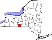
Chemung County is a county in the Southern Tier of the U.S. state of New York. The population was 84,148 as of the 2020 census. Its county seat is Elmira. Its name is derived from a Delaware Indian village whose name meant "big horn".

<span class="mw-page-title-main">Tioga County, New York</span> County in New York, United States

Tioga County is a county in the U.S. state of New York. As of the 2020 census, the population was 48,455. Its county seat is Owego. Tioga County is part of the Binghamton metropolitan area.

<span class="mw-page-title-main">Ashland, Chemung County, New York</span> Town in New York, United States

Ashland is a town in Chemung County, New York, United States. The population was 1,515 at the 2020 census. The town is named after the home of Henry Clay.

Chemung is a town in Chemung County, New York, United States. The population was 2,368 at the 2020 census. The town name is derived from the Chemung River, which means "Big Horn" in the native language.

<span class="mw-page-title-main">Elmira Heights, New York</span> Village in New York, United States

Elmira Heights is a village in Chemung County, New York, United States. The population was 4,097 at the 2010 census. The village is primarily within the town of Horseheads, but part of the village is in the town of Elmira. The village is a northern suburb of the city of Elmira. It is part of the Elmira, New York Metropolitan Statistical Area.

Horseheads North is a census-designated place (CDP) in Chemung County, New York, United States. It is part of the Elmira Metropolitan Statistical Area. As of the 2010 census, the population of the CDP was 2,843.

Millport is a village in Chemung County, New York, United States. The population was 312 at the 2010 census. The name comes from its former status as a canal port.

Veteran is a town in Chemung County, New York, United States. The population was 3,363 at the 2020 census. The name of the town honors the first settler, a veteran of two wars.

Catharine is a town in Schuyler County, New York, United States. The population was 1,656 at the 2020 census. The town is one of two in the county named after Catherine Montour, a Native American interpreter and leader in the area. The Town of Catharine is in the southeastern part of the county and is north of Elmira.

Montour is a town in Schuyler County, New York, United States. The population was 2,323 at the 2020 census. The town is one of two towns in the county named after Catherine Montour.

Barton is a town in southwestern Tioga County, New York, United States. The population was 8,570 at the 2020 census. It is southeast of Elmira.

Tioga is a town in Tioga County, New York, United States. The population was 4,455 at the 2020 census. The town is in the southwestern part of the county and lies between Elmira and Binghamton. Tioga is situated in the Southern Tier District of New York.

<span class="mw-page-title-main">Waverly, Tioga County, New York</span> Village in New York, United States

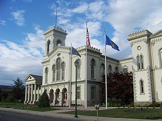
Waverly is the largest village in Tioga County, New York, United States. As of the 2010 U.S. census, Waverly had a population of 4,177. It is located southeast of Elmira in the Southern Tier region. This village was incorporated as the southwest part of the town of Barton in 1854. The village name was conceived by Joseph "Uncle Joe" Hallett, founder of its first Fire Department and pillar of the community, dropping the second "e" from the name of his favorite author's novel, Waverley by Sir Walter Scott. The former village hall is listed on the National Historic Places list.

<span class="mw-page-title-main">Exeter Township, Luzerne County, Pennsylvania</span> Township in Pennsylvania, United States

Exeter Township is a township within the Greater Pittston area of Luzerne County, Pennsylvania, United States. The population was 2,047 at the 2020 census. Upper Exeter and Harding are two villages in the township.

Big Flats is a town in Chemung County, New York, United States. The population was 7,822 at the 2020 census. The town is on the western border of the county, west of Elmira. It is part of the Elmira Metropolitan Statistical Area. The town contains a hamlet also named Big Flats.

<span class="mw-page-title-main">Elmira (town), New York</span> Town in New York, United States

Elmira is a town in Chemung County, New York, United States. It surrounds the city of Elmira on three sides. The town's population was 6,872 at the 2020 census. The town is in the south-central part of the county, in the Southern Tier of New York. It is part of the Elmira Metropolitan Statistical Area.

<span class="mw-page-title-main">Horseheads, New York</span> Town in New York, United States

Horseheads is a town in Chemung County, New York, United States. The population was 19,412 at the 2020 census. The name of the town is derived from the number of bleached horses' skulls once found there.

<span class="mw-page-title-main">Southport, New York</span> Town in New York, United States

Southport is a town in Chemung County, New York, United States. The population was 9,684 according to the 2020 census. The town is located in the southwestern corner of Chemung County and is southwest of the city of Elmira. It is part of the Elmira Metropolitan Statistical Area.

<span class="mw-page-title-main">Bainbridge, New York</span> Town in New York, United States

Bainbridge is a town in Chenango County, New York, United States. The population was 3,308 at the 2010 census. The town is at the eastern border of Chenango County, halfway between Binghamton and Oneonta.

Nichols is a town in Tioga County, New York, United States. The town contains a village also called Nichols. The town is on the south border of both the county and the state. The town is halfway between Binghamton and Elmira. The population was 2,357 at the 2020 census. The town is named after Colonel Nichols, an early landowner.

References

  1. "ArcGIS REST Services Directory". United States Census Bureau. Retrieved September 20, 2022.
  2. 1 2 "2020 United States Census, QuickFacts Horseheads village, New York". United States Census Bureau. U.S. Census Bureau. Archived from the original on February 12, 2020. Retrieved December 9, 2021.
  3. "Sullivan Expedition Against the Iroquois Indians 1779" (PDF). Bucknell University. Retrieved December 27, 2013.
  4. 1 2 "History of Horseheads NY". Horseheads NY Historical Society. Archived from the original on December 28, 2013. Retrieved February 11, 2017.
  5. Smith, Andrea Lynn; John, Randy A. (2020). "Monuments, Legitimization Ceremonies, and Haudenosaunee Rejection of Sullivan-Clinton Markers". New York History. 101 (2): 343–365. doi:10.1353/nyh.2020.0042. S2CID   229355901 . Retrieved April 29, 2022.
  6. "Village History". Village of Horseheads. Retrieved September 21, 2018.
  7. "National Register Information System". National Register of Historic Places . National Park Service. March 13, 2009.
  8. "Census of Population and Housing". Census.gov. Retrieved June 4, 2015.
  9. "U.S. Census website". United States Census Bureau . Retrieved January 31, 2008.

Commons-logo.svg Media related to Horseheads, New York at Wikimedia Commons