Horseheads North, New York

Last updated
Horseheads North, New York
USA New York location map.svg
Red pog.svg
Horseheads North
Location within the state of New York
Coordinates: 42°11′23″N76°48′23″W / 42.18972°N 76.80639°W / 42.18972; -76.80639 Coordinates: 42°11′23″N76°48′23″W / 42.18972°N 76.80639°W / 42.18972; -76.80639
Country United States
State New York
County Chemung
Town Horseheads
Area
[1]
  Total2.24 sq mi (5.80 km2)
  Land2.21 sq mi (5.73 km2)
  Water0.03 sq mi (0.07 km2)
Elevation
940 ft (290 m)
Population
 (2020)
  Total2,761
  Density1,248.76/sq mi (482.06/km2)
Time zone UTC-5 (Eastern (EST))
  Summer (DST) UTC-4 (EDT)
FIPS code 36-35710
GNIS feature ID2389953

Horseheads North is a census-designated place (CDP) in Chemung County, New York, United States. It is part of the Elmira Metropolitan Statistical Area. As of the 2010 census, the population of the CDP was 2,843. [2]

Contents

Geography

Horseheads North is located on the northern side of the town of Horseheads at 42°11′23″N76°48′23″W / 42.18972°N 76.80639°W / 42.18972; -76.80639 (42.189774, -76.806351). [3] It is bordered to the north by the town of Veteran and to the south by Horseheads village.

According to the United States Census Bureau, the location has a total area of 2.2 square miles (5.8 km2), of which 0.03 square miles (0.07 km2), or 1.28%, is water. [2] Newtown Creek, a tributary of the Chemung River which in turn flows into the Susquehanna River, forms part of the southeast boundary of the CDP.

New York State Route 14 passes through the area just west of the CDP.

Demographics

Historical population
CensusPop.
2020 2,761
U.S. Decennial Census [4]

As of the census [5] of 2000, there were 2,852 people, 1,091 households, and 833 families residing in the CDP. The population density was 1,239.1 per square mile (478.8/km2). There were 1,116 housing units at an average density of 484.9/sq mi (187.3/km2). The racial makeup of the CDP was 96.88% White, 0.84% African American, 0.14% Native American, 1.23% Asian, 0.04% from other races, and 0.88% from two or more races. Hispanic or Latino of any race were 0.46% of the population.

There were 1,091 households, out of which 35.1% had children under the age of 18 living with them, 64.0% were married couples living together, 10.0% had a female householder with no husband present, and 23.6% were non-families. 18.9% of all households were made up of individuals, and 9.2% had someone living alone who was 65 years of age or older. The average household size was 2.61 and the average family size was 3.00.

In the CDP, the population was spread out, with 26.6% under the age of 18, 5.4% from 18 to 24, 27.8% from 25 to 44, 25.6% from 45 to 64, and 14.6% who were 65 years of age or older. The median age was 40 years. For every 100 females, there were 90.6 males. For every 100 females age 18 and over, there were 89.3 males.

The median income for a household in the CDP was $50,182, and the median income for a family was $54,419. Males had a median income of $35,873 versus $26,852 for females. The per capita income for the CDP was $21,813. About 3.2% of families and 4.8% of the population were below the poverty line, including 4.7% of those under age 18 and 12.0% of those age 65 or over.

Related Research Articles

<span class="mw-page-title-main">Chemung County, New York</span> County in New York, United States

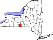
Chemung County is a county in the southern tier of the U.S. state of New York. The population was 84,148 as of the 2020 census. Its county seat is Elmira. Its name is derived from a Delaware Indian village whose name meant "big horn".

<span class="mw-page-title-main">Willow Street, Pennsylvania</span> Census-designated place in Pennsylvania, United States

Willow Street is an unincorporated community and census-designated place (CDP) in Lancaster County, Pennsylvania, United States. The population was 7,578 at the 2010 census. In the early part of the 20th century the main thoroughfare in town was lined with willow trees on both sides for the length of the town, hence the community's name. As time marched on and the town grew, the road was widened and sidewalks were installed which required the trees be removed. Only a few of the original trees remain to this day.

<span class="mw-page-title-main">South San Gabriel, California</span> Census-designated place in California, United States

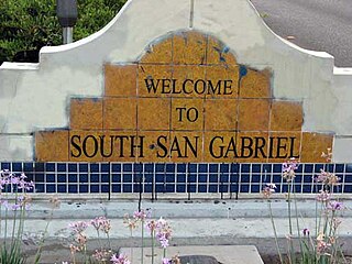
South San Gabriel is a census-designated place (CDP) in Los Angeles County, California, United States. The population was 8,070 at the 2010 census, up from 7,595 at the 2000 census.

Pistakee Highlands is a census-designated place (CDP) in McHenry County, Illinois, United States. It consists primarily of an unincorporated area of McHenry County adjoining Pistakee Bay, within the McHenry post office, and is located just northeast of Johnsburg. Per the 2020 census, the population was 3,237.

<span class="mw-page-title-main">Baldwinville, Massachusetts</span> CDP in Massachusetts, United States

Baldwinville is an unincorporated village and census-designated place (CDP) in the town of Templeton in Worcester County, Massachusetts, United States. The population was 2,028 at the 2010 census. The name also refers to the local post office or railroad station.

<span class="mw-page-title-main">Quinnesec, Michigan</span> Census-designated place & unincorporated community in Michigan, United States

Quinnesec is an unincorporated community in Dickinson County in the U.S. state of Michigan. It is a census-designated place (CDP) for statistical purposes and has no legally recognized status as a municipality. The population was 1,191 at the 2010 census. It is part of the Iron Mountain, MI–WI Micropolitan Statistical Area.

West Elmira is a suburban census-designated place (CDP) in Chemung County, New York, United States. The population was 4,967 at the 2010 census. It is adjacent to the city of Elmira on its west side. West Elmira is in the southwest part of the town of Elmira. It is part of the Elmira Metropolitan Statistical Area.

South Hill is a census-designated place (CDP) in Tompkins County, New York, United States. The population was 6,673 at the 2010 census.

<span class="mw-page-title-main">St. Stephens, North Carolina</span> Census-designated place in North Carolina, United States

St. Stephens is a census-designated place (CDP) in Catawba County, North Carolina, United States. The population was 8,759 at the 2010 census, down from 9,439 in 2000. It is part of the Hickory–Lenoir–Morganton Metropolitan Statistical Area.

<span class="mw-page-title-main">Mifflinville, Pennsylvania</span> Census-designated place in Pennsylvania, United States

Mifflinville is an unincorporated community and census-designated place (CDP) in Columbia County, Pennsylvania, United States. The population was 1,253 at the 2010 census. It is part of the Bloomsburg–Berwick Micropolitan Statistical Area.

<span class="mw-page-title-main">Nuremberg, Pennsylvania</span> Census-designated place in Pennsylvania, United States

Nuremberg is a census-designated place (CDP) in Schuylkill and Luzerne counties, Pennsylvania, United States. The population was 434 at the 2010 census.

<span class="mw-page-title-main">Gastonville, Pennsylvania</span> Census-designated place in Pennsylvania, United States

Gastonville is a census-designated place (CDP) in Washington County, Pennsylvania, United States. The population was 2,818 at the 2010 census.

Red Butte is a census-designated place (CDP) in Natrona County, Wyoming, United States. It is part of the Casper, Wyoming Metropolitan Statistical Area. The population was 1,430 at the 2020 census.

<span class="mw-page-title-main">Salisbury (CDP), Massachusetts</span> Census-designated place in Massachusetts, United States

Salisbury is a census-designated place (CDP) in the town of Salisbury in Essex County, Massachusetts, United States. The population was 4,869 at the 2010 census.

Big Flats is an unincorporated community and census-designated place (CDP) within the town of Big Flats in Chemung County, New York, United States. The population of the CDP was 5,277 at the 2010 census, out of a total population in the town of 7,595.

<span class="mw-page-title-main">Horseheads (village), New York</span> Village in New York, United States

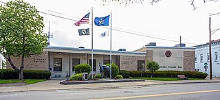
Horseheads is a village in Chemung County, New York, United States. The population was 6,606 at the 2020 census. The name is derived from the number of bleached skulls of pack horses left behind by the Sullivan Expedition.

<span class="mw-page-title-main">Horseheads, New York</span> Town in New York, United States

Horseheads is a town in Chemung County, New York, United States. The population was 19,485 at the 2010 census. The name of the town is derived from the number of bleached horses' skulls once found there.

Southport is a census-designated place (CDP) in the town of Southport in Chemung County, New York, United States. The population of the CDP was 7,238 at the 2010 census, out of a total population in the town of 10,940.

Lake Carroll is a census-designated place (CDP) in Carroll County, Illinois, United States, surrounding a lake of the same name. It is in northeastern Carroll County and is bordered to the north by Stephenson County. It is 10 miles (16 km) northeast of Mount Carroll, the county seat, and 20 miles (32 km) southwest of Freeport.

<span class="mw-page-title-main">Dover-Foxcroft (CDP), Maine</span> CDP in Maine, United States

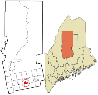
Dover-Foxcroft is a census-designated place (CDP) in the town of Dover-Foxcroft in Piscataquis County, Maine, United States. The population was 2,592 at the 2000 census.

References

  1. "ArcGIS REST Services Directory". United States Census Bureau. Retrieved September 20, 2022.
  2. 1 2 "Geographic Identifiers: 2010 Demographic Profile Data (G001): Horseheads North CDP, New York". U.S. Census Bureau, American Factfinder. Archived from the original on February 12, 2020. Retrieved November 4, 2014.
  3. "US Gazetteer files: 2010, 2000, and 1990". United States Census Bureau. 2011-02-12. Retrieved 2011-04-23.
  4. "Census of Population and Housing". Census.gov. Retrieved June 4, 2016.
  5. "U.S. Census website". United States Census Bureau . Retrieved 2008-01-31.