Hov, Faroe Islands

Last updated
Hov
Village and municipality
Hov Municipality
Hovs kommuna (Faroese)
Hov.2.jpg
Hov, view towards east
Map-position-hovs-kommuna-2005.png
Location of Hovs kommuna in the Faroe Islands
Faroe Islands location map.svg
Red pog.svg
Hov
Location of Hov village in the Faroe Islands
Coordinates: 61°30′30″N6°45′29″W / 61.50833°N 6.75806°W / 61.50833; -6.75806
StateFlag of Denmark (state).svg  Kingdom of Denmark
Constituent countryFlag of the Faroe Islands.svg  Faroe Islands
Island Suduroy
MunicipalityHovs
Population
 (March 2023) [1]
  Total104
Time zone GMT
  Summer (DST) UTC+1 (WEST)
Postal code
FO 960
Climate Cfc

Hov is a village located on Suduroy's east coast, in the Faroe Islands; it is frequently mentioned in the country's history.

Contents

Salmon sea farming has been practiced in Hov since the 1980s. North of Hov along the old road to Øravík are interesting basalt columns that march along the hills.

The Church

The wooden church in Hov was originally built in Vágur on Kirkjukletti in 1862. It was moved to Hov in 1942. A new church was built in Vágur, it was ready in 1939, after that they could start to take down the old church and move it to Hov, as it was promised 25 years earlier in 1914. [2]

Hovstunnilin - The Hov-Øravík tunnel

In 2007, the road tunnel "Hovstunnilin" opened. [3] In addition to connecting the villages of Hov and Øravík, it connects the southern and the northern parts of the island. It is no longer necessary to drive over the mountain, which can be difficult in wintertime. Now, it takes only 15 minutes to drive from Tvøroyri to Vágur. The tunnel is 2.5 km (or 1.55 mi) long.

Viking History - Viking Chief Havgrímur

The graves of Chieftain Havgrimur and his horse. Hov Faroe Islands the Grave of Viking Chieftain Havgrimur.JPG
The graves of Chieftain Havgrímur and his horse.

According to the Faroese Sagas and local tradition, the first Viking settler on Suðuroy established a farm in Hov, which is said to be named after his pagan hof . His grave is at "undir Homrum" in Hov and is the only chieftain burial site to be found on the Faroes. Hov lies in the middle of the island and the area is flat and wide with a good view out to sea. This enabled Suðuroy's first settlers to follow exactly what was happening on the sea around.

The viking Havgrímur who was chief of half of the country lived in Hov in the 10th century. [4] His burial plot is located in the hills above the village, but was largely destroyed when opened in by amateur archaeologists in 1834.

The area west of Hov

West of Hov is a waterfall with the name Foldarafossur. It lies in Hovsá, which runs from Vatnsnes and is the line of demarcation between the villages of Porkeri and Hov. The waterfall is formed at the place where Hovsá runs over the edge at Foldarshamri, and a bit further to the south there is a mountain pass which is called Foldarsskarð. These three place names all have the same origin, and linguists think that the name comes from the soil (in Faroese also foldin) below these localities.

Approx. 30 years ago, the electricity company SEV commenced construction work in Hovsdal, so that the hydropower could be converted into electricity, and a dam was built approx. ½ km west of Foldarafoss. Therefore, the waterfall does not have the same power as before, but if it rains a lot, and water flows out over the dam, the waterfall may show some of its old power.

Myri Museum - The Old Shop

There is an old building down in the harbour of Hov, which now is a museum, an art gallery and a café. The eastern part of the house is called Fiskastovan. The western part of the house has been a shop until sometime in 1980s. Other parts of the house and the area around it has been used for clip fish industry, the fish was dried outside the house on the flat stones. A white flag was raised in order to let people in the village know when there was work for them. That was before the phone was a possibility. The house was in bad shape a few years ago, but now it has been restored. Some interesting items and old books with peoples names and how much they earned etc. are still in the house. The house was first located in Vágur, but it was moved to Hov, just like the church was. Fiskastovan á Mýri is used for many different purposes: Art exhibitions, café, small concerts, lectures, dinner for groups etc.

See also

Related Research Articles

<span class="mw-page-title-main">Transport in the Faroe Islands</span> Internal transport system of the Faroe Islands

The Faroe Islands is served by an internal transport system based on roads, ferries, and helicopters. As of the 1970s, the majority of the population centres of the Faroe Islands have been joined to a single road network, connected by bridges and tunnels.

<span class="mw-page-title-main">Fámjin</span> Municipality and village in Faroe Islands, Kingdom of Denmark

Fámjin is a village located on the western side of Suðuroy, the southernmost island in Faroe Islands. Fámjin is looking directly out to the North Atlantic Ocean.

<span class="mw-page-title-main">Klaksvík</span> Town in Faroe Islands, Kingdom of Denmark

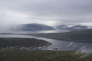
Klaksvík is the second largest town of the Faroe Islands behind Tórshavn. The town is located on Borðoy, which is one of the northernmost islands. It is the administrative centre of Klaksvík municipality.

<span class="mw-page-title-main">Tvøroyri</span> Village in Faroe Islands, Kingdom of Denmark

Tvøroyri is a village on the north side of the Trongisvágsfjørður on the east coast of Suðuroy island in the Faroe Islands. Together with Froðba, Trongisvágur, Líðin and Øravík it forms Tvøroyri Municipality.

<span class="mw-page-title-main">Porkeri</span> Municipality and village in Faroe Islands, Kingdom of Denmark

Porkeri is a village in the Faroe Islands, situated northeast of Vágur on Suðuroy's east coast.

<span class="mw-page-title-main">Suðuroy</span> Island in Faroe Islands, Kingdom of Denmark

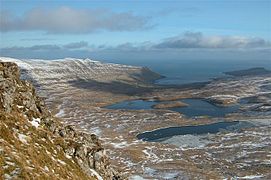
Suðuroy is the southernmost of the Faroe Islands. The island covers 163.7 square kilometres (63.2 sq mi). In 2018 the population was 4,601. Suðuroy region (sýsla) comprises this island and Lítla Dímun, the next isle northward in the Faroes, which is uninhabited.

<span class="mw-page-title-main">Sørvágur</span> Village in Faroe Islands, Kingdom of Denmark

Sørvágur is a village on the island of Vágar in the Faroe Islands.

<span class="mw-page-title-main">Sandvík</span> Village in Faroe Islands, Kingdom of Denmark

Sandvík is the northernmost village of the island of Suðuroy in the Faroe Islands. It is situated on the northern side of a shallow fjord. The village was previously known as Hvalvík. It changed its name to Sandvík in 1913 as there was too much confusion regarding mail delivery, because there is another village named Hvalvík on Streymoy. The village had originally been known as Sandvík during the Viking Age.

<span class="mw-page-title-main">Sumba, Faroe Islands</span> Municipality and village in Faroe Islands, Kingdom of Denmark

Sumba is the southernmost village of the Faroe Islands, located on the island of Suðuroy. It is located in Sumbiar Municipality.

<span class="mw-page-title-main">Vágur</span> Municipality and village in Faroe Islands, Kingdom of Denmark

Vágur, meaning bay, is a town and municipality on the island of Suðuroy, part of the Faroe Islands.

<span class="mw-page-title-main">Øravík</span> Village in Faroe Islands, Kingdom of Denmark

Øravík is a village on the east coast of the island of Suðuroy in the Faroe Islands.

<span class="mw-page-title-main">Vágs Bóltfelag</span> Sports club in Faroe Islands

Vágs Bóltfelag (VB) is a Faroese handball club. It started as a football club, which was founded on 5 June 1905, but later the sport handball became a part of the club. The handball club is based in Vágur in Suðuroy. They play their home matches in the sports hall, Vágshøll on Eiðinum in Vágur. The football club is now known as FC Suðuroy.

<span class="mw-page-title-main">Á Eiðinum</span> Multi-use stadium in Vágur

á Eiðinum is a multi-use stadium in Vágur, which is one of the larger villages in the southernmost island Suduroy in the Faroe Islands. It is currently used mostly for football matches and is the home ground of FC Suðuroy, formerly called VB/Sumba. The stadium holds 3,000 people, but has only 330 seats.

<span class="mw-page-title-main">Languages of the Faroe Islands</span>

The national language of the Faroe Islands is Faroese. The Faroese language is a Germanic language which is descended from Old Norse. Danish is the official second language.

<span class="mw-page-title-main">Aggi Ásgerð Ásgeirsdóttir</span> Faroese artist

Aggi Ásgerð Ásgeirsdóttir is a Faroese artist. She was born in Tórshavn, Faroe Islands. She was educated in Denmark and then moved back to the Faroe Islands, to the small village Vágur in Suðuroy, which is the southernmost island. In the summer 2009 Aggi move to Tórshavn or to Argir, now part of the municipality of Tórshavn. While Aggi was living in Suðuroy, her art was her main occupation, and also mentored Ruth Smith Art Museum in Vágur, she was the chairman of the association "Skálin við Skálá", which owns the museum. Aggi often showed the museum for tourists while she was living in Vágur.

<span class="mw-page-title-main">Bjarni Johansen</span> Faroese politician and former footballer

Bjarni Johansen is a Faroese politician and former goal keeper. He is the current mayor of Vágur Municipality, elected for the Social Democratic Party in November 2020 to the Municipality and became mayor from 1 January 2021. He is former chairman for the Faroese football association FC Suðuroy.

<span class="mw-page-title-main">Vágsfjørður</span> Fjord on the island of Suðuroy in the Faroe Islands

Vágsfjørður is a fjord on the island of Suðuroy in the Faroe Islands. The fjord is located in the southern part and on the eastern side of the island. The distance between the east and the west coast of Suðuroy is very short from Vágsfjørður to Vágseiði. Between the fjord and Vágseiði is a lake which is called Vatnið. There are five villages around the fjord. In the bottom of the fjord is Vágur, which is one of the largest of the villages in Suðuroy. Further east on the northern side of the fjord is Porkeri, in between Vágur and Porkeri is the small village Nes, where a famous artist Ruth Smith lived. She drowned while swimming in Vágsfjørður at the age of 45.

<span class="mw-page-title-main">Borgarknappur</span> Mountain located on the island of Suðuroy

Borgarknappur is a mountain in Suðuroy, Faroe Islands.

<span class="mw-page-title-main">Vágseiði</span> Location in Vágur, Faroe Islands

Vágseiði is an area in Vágur, Faroe Islands, located on the west coast of Suðuroy west of the village Vágur, from which it takes its name. Eiði is the Faroese word for isthmus. The distance between the east and the west coast of Vágur is only one km. There is a lake between the village and Vágseiði, the lake is called Vatnið, which is the Faroese word for Lake. The football stadium of FC Suðuroy and the sports hall Vágshøll are located on Vágseiði, 100-200 m from the cliffs. The natural harbour on Vágseiði is called Kleivin. The 200m high cliff south of Vágseiði is called Skúvanes, and the cliffs from Skúvanes towards south are called Eggjarnar. There is a skerry, which looks like some rocks, in the bay of Vágseiði, this skerry is called Heltnarnar. The sea is often rough here and the waves often break against the cliffs here, and often Heltnarnar almost disappear in the surf.

<span class="mw-page-title-main">Fjords in the Faroe Islands</span> List of fjords in the Faroe Islands

The Faroe Islands consist of 18 islands, several of which are deeply incised by fjords.

References

  1. Population, municipalities and villages Statistics Faroe Islands
  2. Hov.fo
  3. pdf.istak.is Archived 2011-07-22 at the Wayback Machine
  4. "Hov.fo". Archived from the original on 2011-07-20. Retrieved 2010-06-09.