Sandur, Faroe Islands

Last updated

Sandur
Sand (Danish)
Municipality and village
Sandur Municipality
Sands kommuna (Faroese)
Sandur village street.JPG
Sandur.png
Faroe Islands location map.svg
Red pog.svg
Sandur
Location in the Faroe Islands
Coordinates: 61°50′10″N6°48′38″W / 61.83611°N 6.81056°W / 61.83611; -6.81056
StateFlag of Denmark (state).svg  Kingdom of Denmark
Constituent countryFlag of the Faroe Islands.svg  Faroe Islands
Island Sandoy
Government
  Mayor Brandur Sandoy
Area
  Total48 km2 (19 sq mi)
Population
 (January 2024)
  Total529
  Density11/km2 (29/sq mi)
Time zone GMT
  Summer (DST) UTC+1 (WEST)
Postal code
FO 210
Climate Cfc
Website www.sandur.fo

Sandur (meaning sandy beach; Danish : Sand) is a village on the south coast of the island of Sandoy in the Faroe Islands. The Sandur hoard of silver coins, dating to the end of the 11th century, attests to the long history of the village. In January 2024, the population stood at 529.

Contents

The municipality of Sandur consists of the village of Sandur only. It is the most populous place on the "Sand Island", and is situated on a peninsula between the lakes of Gróthúsvatn in the northwest and Sandsvatn in the northeast, facing the inlets of Grótvík and Sandsvágur in the south.

History

Sandur is an old site of the thing where every year the local Várting was held. Excavations here have unearthed a stave church from the 11th century, where today there is a typical Faroese wooden church with a grass roof. In 1988, the modern church suffered a devastating fire in which all of the church's silver melted. The fire turned out to be arson. In the following year, the church was restored, just in time for its 150th anniversary.

The most reliable information of a church in the Faroe Islands is that of Sandur, dating back to the 11th century. Sandur church.JPG
The most reliable information of a church in the Faroe Islands is that of Sandur, dating back to the 11th century.

In 1863 while extending the churchyard, a treasure of silver was found consisting of 98 coins from the 11th century, half of them of German origin. Furthermore, in 1989 archaeologists discovered a pagan burial ground from the times of Viking occupation. The burial included the well-preserved skeleton of a woman from the Faroe Islands in a grave 1.5 m (4 ft 11 in) long. The grave also included three beads of amber, a blue glass bead, and a knife.

In the open-air museum of the Danish national museum close to Copenhagen one can see a water-mill which originally, in the 18th century, was installed in Sandur. The local museum Sands Bygdasavn is open in summer. It displays objects of everyday life belonging to the ancestors of the local inhabitants.

Transport and tourism

Sandur can be reached from Tórshavn via the Sandoyartunnilin in circa 30 minutes. A direct Strandfaraskip Landsins bus service connects the two. All villages on the island except Skarvanes can be reached by bus from Sandur. They are therefore suitable for day trips. Due to the topography of the island walking-tours are suitable for casual strolling and cyclists. Popular trips are to Søltuvík on the west coast, Skarvanes in the south (with slightly more demanding hiking) and Húsavík on the east coast.

The small passenger only ferry MV Sildberin departs Sandur for Skúvoy, an island to the south. Particularly interesting is the tour in the Faroese rowboat Hvíthamar from Sandur to the bird rocks on the west coast or to Skúvoy. Boatbuilder Jóan Petur Clementsen himself is rowing.

The campsite á Munkinum is one of the camping sites on Sandoy. The other two camping sites are in Húsavík and Dalur. In addition Sandsvatn and Gróthúsvatn are attractive places for fishing. The Hotel Ísansgarður has been reconstructed. The tourist information in Sandur provides up-to-date information on private accommodation and holiday homes.

Climate

Climate data for Sandur, Sandoy, 5 m.a.s.l.
MonthJanFebMarAprMayJunJulAugSepOctNovDecYear
Record high °C (°F)11.1
(52.0)
13.2
(55.8)
12.2
(54.0)
13.2
(55.8)
18.9
(66.0)
19.0
(66.2)
21.4
(70.5)
19.8
(67.6)
15.4
(59.7)
14.8
(58.6)
12.4
(54.3)
12.4
(54.3)
21.4
(70.5)
Mean daily maximum °C (°F)5.7
(42.3)
5.9
(42.6)
6.3
(43.3)
7.5
(45.5)
9.8
(49.6)
11.8
(53.2)
13.0
(55.4)
13.2
(55.8)
11.3
(52.3)
9.5
(49.1)
7.1
(44.8)
6.1
(43.0)
8.9
(48.0)
Daily mean °C (°F)3.9
(39.0)
4.1
(39.4)
4.3
(39.7)
5.5
(41.9)
7.7
(45.9)
9.6
(49.3)
11.0
(51.8)
11.2
(52.2)
9.5
(49.1)
7.8
(46.0)
5.4
(41.7)
4.2
(39.6)
7.0
(44.6)
Mean daily minimum °C (°F)1.6
(34.9)
1.9
(35.4)
2.1
(35.8)
3.2
(37.8)
5.4
(41.7)
7.5
(45.5)
9.1
(48.4)
9.4
(48.9)
7.5
(45.5)
5.8
(42.4)
3.2
(37.8)
1.9
(35.4)
4.9
(40.8)
Record low °C (°F)−7.8
(18.0)
−6.0
(21.2)
−7.9
(17.8)
−5.1
(22.8)
−2.4
(27.7)
0.7
(33.3)
4.4
(39.9)
3.1
(37.6)
0.8
(33.4)
−2.3
(27.9)
−6.1
(21.0)
−9.3
(15.3)
−9.3
(15.3)
Average precipitation mm (inches)133
(5.2)
89
(3.5)
110
(4.3)
69
(2.7)
64
(2.5)
58
(2.3)
71
(2.8)
78
(3.1)
118
(4.6)
146
(5.7)
125
(4.9)
131
(5.2)
1,193
(47.0)
Average precipitation days (≥ 1.0 mm)191518131111121116191719179
Source: Danish Meteorological Institute [2]

Sands Listasavn Art Museum

The Art Museum of Sandur is open from May to October every day except for Monday from 14:00–16:00. In wintertime it is open Sundays from 14:00–16:00. [3] The museum and its art works were a gift from Sofus Olsen. It was built in 2005 and handed over to the municipality of Sandur in December 2005, on Olsen's 92nd birthday. [4]

Sport

Sandur is best known for its football club, B71 Sandoy, which has enjoyed modest success in both the Faroe Islands Premier League and UEFA.

See also

Related Research Articles

<span class="mw-page-title-main">Transport in the Faroe Islands</span> Internal transport system of the Faroe Islands

The Faroe Islands is served by an internal transport system based on roads, ferries, and helicopters. As of the 1970s, the majority of the population centres of the Faroe Islands have been joined to a single road network, connected by bridges and tunnels.

<span class="mw-page-title-main">Húsavík, Faroe Islands</span> Village in Faroe Islands, Kingdom of Denmark

Húsavík is an old village located on the east of the island of Sandoy, in Húsavík Municipality, Faroe Islands.

<span class="mw-page-title-main">Skúvoy</span> Island in Faroe Islands, Kingdom of Denmark

Skúgvoy is an island in the central Faroe Islands, located to the south of Sandoy.

<span class="mw-page-title-main">Sandoy</span> Island in Faroe Islands, Kingdom of Denmark

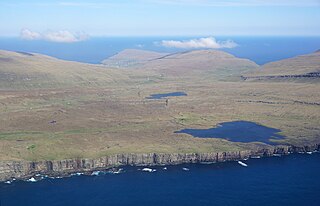
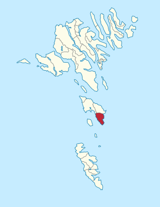
Sandoy is the first of the five southern islands that make up the Faroe chain, the fifth biggest of all the Faroe Islands, an autonomous region of the Kingdom of Denmark. It also refers to the region that includes this island along with Skúvoy and Stóra Dímun. As of January 2020, the largest population centre on the island is the village of Sandur with a population of 532. Other settlements include Skarvanes, Skopun, Skálavík, Húsavík and Dalur.

<span class="mw-page-title-main">Skúvoy, Skúvoy</span> Municipality and village in Faroe Islands, Kingdom of Denmark

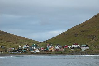
The village Skúvoy lies on the east side of the island with the same name.

<span class="mw-page-title-main">Sandvík</span> Village in Faroe Islands, Kingdom of Denmark

Sandvík is the northernmost village of the island of Suðuroy in the Faroe Islands. It is situated on the northern side of a shallow fjord. The village was previously known as Hvalvík. It changed its name to Sandvík in 1913 as there was too much confusion regarding mail delivery, because there is another village named Hvalvík on Streymoy. The village had originally been known as Sandvík during the Viking Age.

The Sandur hoard of the Faroe Islands was found in Sandur in 1863 and consists of 98 medieval silver coins, which were probably buried between 1070 and 1080. The hoard is the oldest and only coin hoard found on the archipelago.

<span class="mw-page-title-main">Skopun</span> Town on the Faroe Islands, Denmark

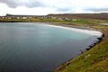
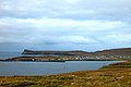
Skopun is a town in the Faroe Islands situated on the northern coast of Sandoy.

<span class="mw-page-title-main">Faroese art</span>

Faroese art is art by artists living in the Faroe Islands and art by Faroese nationals living abroad. In the Faroe Islands, art is an important part of everyday life and in the public debate. It may be the special light in the Faroes which causes so many to express themselves in painting. The ever-changing Faroese weather and light provide opportunities for endless nuances, something which has fascinated both foreign and local artists over the years. However, the history of Faroese art is short, and can only be dated a couple of hundred years back. Lack of time, light and materiel may have caused the late appearance of painting. But despite this, the islands have a very active art scene. A great many of the Faroese artists of today resent being reminded that Faroese art is a comparatively recent phenomenon. They find such an observation annoying as regards their artistic work, and they claim that such a statement has no bearing whatsoever on them as artists as their frame of reference is both local and global.

<span class="mw-page-title-main">Strandfaraskip Landsins</span> Government agency for public transport in the Faroe Islands

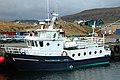
Strandfaraskip Landsins is the government agency for public transport in the Faroe Islands. It is owned by the Faroese national government under the Ministry of Finance (Fíggjamálaráðið) and runs seven ferry routes and a number of bus routes.

<span class="mw-page-title-main">Inni í Dal</span> Location on the island of Sandoy, The Faroe Islands

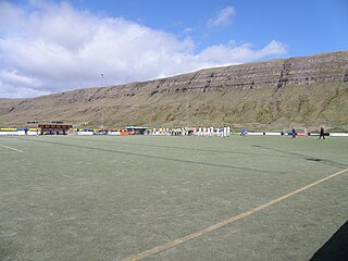
Inni í Dal, roughly translated to "In the Valley", is a location on the island of Sandoy, The Faroe Islands. Inni í Dal is the home ground of local football team B71, but also the location the joint public secondary school of Sandoy, Sandoyar Meginskúli.

<span class="mw-page-title-main">Skálavík</span> Municipality and village in Faroe Islands, Kingdom of Denmark

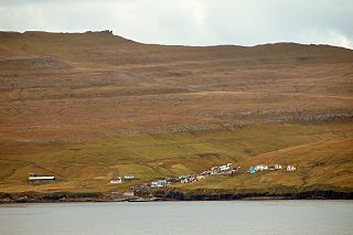
Skálavík is a village and municipality on the eastern coast of the Faroese island Sandoy.

<span class="mw-page-title-main">Brandur Sandoy</span> Faroese politician, sheep farmer, and businessman

Brandur Sandoy is a Faroese politician, sheep farmer and businessman. His surname is the same as the name of the island Sandoy, where he lives. He runs a sheep farm in Inni í Dal between Sandur and Skopun, near the school and football stadium of B71 Sandoy. He also runs a small business named BS-Smíð and rents a holiday home together with his wife Anja Sandoy, with whom he has three children: Várdis, Pauli and Pál. He is a former football player, he played for B71 Sandoy in the 1990s.

<span class="mw-page-title-main">Sandoyartunnilin</span> Undersea road tunnel in the Faroe Islands

Sandoyartunnilin is an undersea road tunnel in the Faroe Islands. It connects the main island of Streymoy with Sandoy to the south. The length of the tunnel is 10.8 kilometres (6.7 mi) and the estimated cost is 860 million DKK. The tunnel opened for traffic on 21 December 2023, after which the ferry Teistin ceased its route between Gamlarætt on Streymoy and Skopun on Sandoy. The tunnel crosses the Skopunarfjørður and runs from Gamlarætt to Traðardalur in central Sandoy, near the Inni í Dal stadium.

<span class="mw-page-title-main">Demmus Hentze</span> Faroese politician and lawyer

Demmus Hentze was a Faroese politician and lawyer. He served as the Finance Minister of the Faroe Islands from 1975 to 1981.

<span class="mw-page-title-main">Húsavík Municipality</span> Place in Faroe Islands, Kingdom of Denmark

Húsavík Municipality is a municipality of the Faroe Islands. The town of Húsavík is the administrative centre.

The Suðuroyartunnilin is a proposed submerged fixed-link in the Faroe Islands, linking the island of Suðuroy to Sandoy. As of 2023, all vehicles and cargo, and virtually all passenger traffic must use the ferry service.

<span class="mw-page-title-main">Fjords in the Faroe Islands</span> List of fjords in the Faroe Islands

The Faroe Islands consist of 18 islands, several of which are deeply incised by fjords.

<span class="mw-page-title-main">Gamlarætt</span> Ferry port in the Faroe Islands

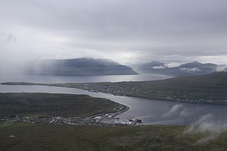
Gamlarætt is a ferry port in the Faroe Islands. It is situated on the southwestern side of the island of Streymoy, the largest island in the Faroes, between the villages of Velbastaður and Kirkjubøur. It accommodates ferry services to the islands of Sandoy and Hestur. The port is also used for local salmon farms.

References

  1. George Vaughan Chichester Young (1979). From the Vikings to the Reformation: Chronicle of the Faroe Islands to 1538. Shearwater Press Ltd. pp.  43. ISBN   0-904980-20-0. sandur faroe.
  2. "The Climate of The Faroe Islands - with Climatological Standard Normals, 1961–1990 Greenland" (PDF). Danish Meteorological Institute. Retrieved 19 August 2015.
  3. Visit Sandoy. "Listasavnið á Sandi". Visit Sandoy. Retrieved 4 December 2011.(in Faroese)
  4. Articon. "Listasavnið á Sandi". Articon. Archived from the original on 20 July 2011. Retrieved 4 December 2011.(in Faroese)

61°50′33″N6°48′28″W / 61.84250°N 6.80778°W / 61.84250; -6.80778